Home
Browse
Ask Us
Chat
Harmful Language Statement
Log in
Advanced Search
Year
1876
1877
1878
1879
1880
1881
1882
1883
1884
1885
1886
1887
1888
1889
1890
1891
1892
1893
1894
1895
1896
1897
1898
1899
1900
1901
1902
1903
1904
1905
1906
1907
1908
1909
1910
1911
1912
1913
1914
1915
1916
1917
1918
1919
1920
1921
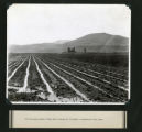
1922
1923
1924
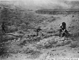
1925
1926
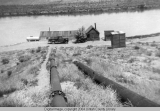
1927
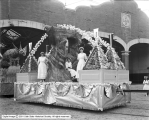
1928
1929
1930
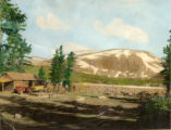
1931
1932
1933
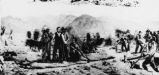
1934
1935
1936
1937
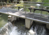
1938
1939
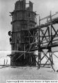
1940
1941
1942
1943
1944
1945
1946
1947
1948
1949
1950
1951
1952
1953
1954
1955
1956
1957
1958
1959
1960
1961
1962
1963
1964
1965
1966
1967
1968
1969
1970
1971
1972
1973
1974
1975
1976
1977
1978
1979
1980
1981
1982
1983
1984
1985
1986
1987
1988
1989
1990
1991
1992
1993
1994
1995
1996
1997
1998
1999
2000
2001
2002
2003
2004
2005
2006
2007
2008
2009
2010
2011
2012
2013
2014
2015
2016
2017
2018
2019
2020
2021
2022
TO
1876
1877
1878
1879
1880
1881
1882
1883
1884
1885
1886
1887
1888
1889
1890
1891
1892
1893
1894
1895
1896
1897
1898
1899
1900
1901
1902
1903
1904
1905
1906
1907
1908
1909
1910
1911
1912
1913
1914
1915
1916
1917
1918
1919
1920
1921
1922
1923
1924
1925
1926
1927
1928
1929
1930
1931
1932
1933
1934
1935
1936
1937
1938
1939
1940
1941
1942
1943
1944
1945
1946
1947
1948
1949
1950
1951
1952
1953
1954
1955
1956
1957
1958
1959
1960
1961
1962
1963
1964
1965
1966
1967
1968
1969
1970
1971
1972
1973
1974
1975
1976
1977
1978
1979
1980
1981
1982
1983
1984
1985
1986
1987
1988
1989
1990
1991
1992
1993
1994
1995
1996
1997
1998
1999
2000
2001
2002
2003
2004
2005
2006
2007
2008
2009
2010
2011
2012
2013
2014
2015
2016
2017
2018
2019
2020
2021
2022
Type
Image
666
Text
14
Format
image/jpeg
621
application/pdf
45
Collection
Art and Art History
1
Beckwith Photograph Collection
16
City Engineers
1
Civilian Conservation Corps
6
Classified Photographs
90
Elias Hicks Blackburn Papers, 1848-1908
1
Extractions from the Land: Mining and...
1
Great Basin Association Photographs
3
Hidden Water - Salt Lake County Water...
53
Lennox and Catherine Tierney Photogra...
6
More Than A Flag: Utah State Flag Red...
4
Multimedia Archives Photographs - Res...
9
Murray Museum
3
Peoples of Utah
2
Peoples of Utah Revisited
9
Photo Archives
370
Regional History Center
13
Sanborn Fire Insurance Maps
1
Shipler Commercial Photographers
21
Sustainability U
1
Theses & Dissertations
2
Thorne Photographs
23
Utah River Running Photo Archives
3
Vernal Express Photographs
18
Westminster College Institutional Rep...
8
Westminster College Photographs
1
More
Filters:
Type:
"Image"
51
-
75
of
666
<
1
2
3
4
5
6
7
8
9
10
>
Gallery view
Number of results to display per page
10
25
50
100
200
Sort by Relevance
Sort by Title A-Z
Sort by Title Z-A
Sort by Date Ascending
Sort by Date Descending
Sort by Last Modified Ascending
Sort by Last Modified Descending
Title
Date
Type
Setname
51
Delta Land and Water Company
Image
dc_bpc
52
Escalante Valley Improvement Company Map
1915-11-19
Image
dha_scp
53
Gardens, Japanese: Japan [007]
1950
Image
uum_lctpc
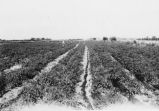
54
Irrigation at a Utah farm
1944; 1945; 1946
Image
uum_map
55
Resolution Committee of International Irrigation Congress
1912-10-01
Image
dha_scp
56
Irrigation P.1
Image
dha_cp
57
Ancient irrigation ditch, La Plata sandstone, Moencopie wash, 10± mil east of Tuba, Ariz., 1909 (photo G-101)
1909
Image
uum_map
58
Big Spill
2009-08-12
Image
uu_hw_slcwd
59
Chipeta Lake
1965; 1966; 1967; 1968; 1969; 1970
Image
ucl_rhc
60
Grand County Float, International Irrigation Congress
1912-09-30
Image
dha_scp
61
Irrigation near Phoenix (249-5)
1962; 1963; 1964; 1965; 1966
Image
uum_map_rr
62
Irrigation-Ditches P.1
1952-07-17
Image
dha_cp
63
Escalante Ranch
Image
ucl_rhc
64
Paradise Park Reservoir
1926
Image
ucl_rhc
65
Nile River, Egypt [032] General (003)
1954; 1955; 1956; 1957; 1958; 1959; 1960; 1961; 1962; 1963; 1964; 1965; 1966; 1967; 1968; 1969; 1970; 1971; 1972; 1973; 1974; 1975; 1976; 1977; 1978; 1979; 1980; 1981; 1982
Image
uum_lctpc
66
Men Building Irrigation Ditches
Image
ucl_rhc
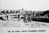
67
Red Cap Flume
1923
Image
ucl_tp
68
Residential landscaping
2007-05-22
Image
uu_hw_slcwd
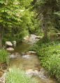
69
"Peter's Sugar Farm" (Farming) Chapter 4 Illustration, before page 25: The head stream was lined with cement in order to prevent the wasting of water by seepage through the soil.
1945; 1946; 1947; 1948
Image
uum_map
70
Canal/ditch crossover
2008-08-28
Image
uu_hw_slcwd
71
Irrigation-Methods P.6
Image
dha_cp
72
Men Pour Concrete
Image
ucl_vep
73
Mt. View Cemetery
2009-04-10
Image
uu_hw_slcwd
74
Red Cap Canal
1923
Image
ucl_tp
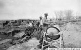
75
Red Cap Flume Construction
Image
ucl_tp
51
-
75
of
666
<
1
2
3
4
5
6
7
8
9
10
>