Home
Browse
Ask Us
Chat
Harmful Language Statement
Log in
Advanced Search
Year
1859
1860
1861
1862
1863
1864
1865
1866
1867
1868
1869
1870
1871
1872
1873
1874
1875
1876
1877
1878
1879
1880
1881
1882
1883
1884
1885
1886
1887
1888
1889
1890
1891
1892
1893
1894
1895
1896
1897
1898
1899
1900
1901
1902
1903
1904
1905
1906
1907
1908
1909
1910
1911
1912
1913
1914
1915
1916
1917
1918
1919
1920
1921
1922
1923
1924
1925
1926
1927
1928
1929
1930
1931
1932
1933
1934
1935
1936
1937
1938
1939
1940
1941
1942
1943
1944
1945
1946
1947
1948
1949
1950
1951
1952
1953
1954
1955
1956
1957
1958
1959
1960
1961
1962
1963
1964
1965
1966
1967
1968
1969
1970
1971
1972
1973
1974
1975
1976
1977
1978
1979
1980
1981
1982
1983
1984
1985
1986
1987
1988
1989
1990
1991
1992
1993
1994
1995
1996
1997
1998
1999
2000
2001
2002
2003
2004
2005
2006
2007
2008
2009
2010
2011
2012
2013
2014
2015
2016
2017
2018
2019
2020
2021
2022
2023
2024
TO
1859
1860
1861
1862
1863
1864
1865
1866
1867
1868
1869
1870
1871
1872
1873
1874
1875
1876
1877
1878
1879
1880
1881
1882
1883
1884
1885
1886
1887
1888
1889
1890
1891
1892
1893
1894
1895
1896
1897
1898
1899
1900
1901
1902
1903
1904
1905
1906
1907
1908
1909
1910
1911
1912
1913
1914
1915
1916
1917
1918
1919
1920
1921
1922
1923
1924
1925
1926
1927
1928
1929
1930
1931
1932
1933
1934
1935
1936
1937
1938
1939
1940
1941
1942
1943
1944
1945
1946
1947
1948
1949
1950
1951
1952
1953
1954
1955
1956
1957
1958
1959
1960
1961
1962
1963
1964
1965
1966
1967
1968
1969
1970
1971
1972
1973
1974
1975
1976
1977
1978
1979
1980
1981
1982
1983
1984
1985
1986
1987
1988
1989
1990
1991
1992
1993
1994
1995
1996
1997
1998
1999
2000
2001
2002
2003
2004
2005
2006
2007
2008
2009
2010
2011
2012
2013
2014
2015
2016
2017
2018
2019
2020
2021
2022
2023
2024
Type
Image
277
Text
86
Sound
8
Format
image/jpeg
170
application/pdf
107
Collection
Art and Art History
35
Beckwith Photograph Collection
5
City Engineers
1
Civilian Conservation Corps
4
Classified Photographs
9
Discovery and Innovation at Universit...
1
George Montgomery Scott Papers
1
Lennox and Catherine Tierney Photogra...
2
Marriott Library Digital Stacks
1
Marriott Library Posters
1
More Than A Flag: Utah State Flag Red...
7
Murray Museum
2
Olympic Legacy
1
Park City Historical Society & Museum
1
Peoples of Utah Revisited
7
Photo Archives
104
Regional History Center
3
Shipler Commercial Photographers
2
Theses & Dissertations
14
Thorne Photographs
2
UScholar Works
1
University Archival Photographs (P0305)
1
Utah Historical Society Oral History ...
8
Utah's Urban Pioneer Folk Music Reviv...
2
Westminster University Institutional ...
56
Westminster University Photographs
6
More
Filters:
Type:
"Image"
26
-
50
of
277
<
1
2
3
4
5
6
7
8
9
10
>
Gallery view
Number of results to display per page
10
25
50
100
200
Sort by Relevance
Sort by Title A-Z
Sort by Title Z-A
Sort by Date Ascending
Sort by Date Descending
Sort by Last Modified Ascending
Sort by Last Modified Descending
Title
Date
Type
Setname
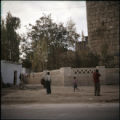
26
Middle East church
1955-11
Image
uum_map
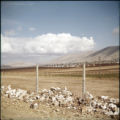
27
Landscape
1955
Image
uum_map
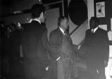
28
Representative Lloyd on Middle-east Trip, January 1970.
1970-01
Image
uum_map
29
Representative Lloyd on Middle-east Trip, January 1970.
1970-01
Image
uum_map
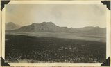
30
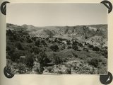
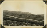
Looking across Big Plains toward Smithsonian Butte (middle background), West Temple (upper right). Foreground forested east slope of Little Creek Mountain, Shinarump; middle distance, dry farm lands on Chinle strata. Washington County, Utah, 1937.
1937
Image
uum_map
31
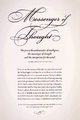
Messenger of Thought
2010
Image
uum_mlp
32
Unidentified fortress, Middle East
1955-11
Image
uum_map
33
Unidentified fortress, Middle East
1955
Image
uum_map
34
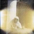
Child near a column
1950; 1951; 1952; 1953; 1954; 1955; 1956; 1957; 1958; 1959
Image
uum_map
35
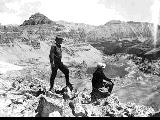
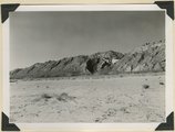
Looking southward across House Rock Valley from West Clark Bench. West dipping Navajo sandstone trenched by Kaibab Creek (middle distance) is a part of the East Kaibab monocline; east dipping limestones (skyline) are the cap rocks of the Kaibab upwarp. Kane County, UT, 1944
1944
Image
uum_map
36
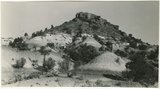
Resevoir Butte
Image
dc_bpc
37
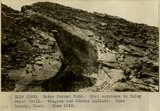
Water Pocket Fold. East entrance to Muley Twist Trail. Wingate and Middle LaPlata. Kane County, UT. June 1918
1918
Image
uum_map
38
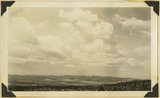
Looking east across Sevier River near Hatch River terraces in middle distance, "Pink Cliffs" (Wasatch) in background bounded by Sevier fault. Garfield County, Utah, 1936.
1936
Image
uum_map
39
Looking northwest across Parunuweap east of Mt. Carmel, Cretaceous in middle ground, Pink Cliffs in distance, 1936.
1936
Image
uum_map
40
Moenkopi formation: Shnabkaib member (lower part), upper red sandstone (upper middle), Shinarump conglomerate (top). East side of Seamans Wash, Kane County, UT. 1943
1943
Image
uum_map
41
Hikers on Hayden Peak overlooking Middle Basin in the Uinta Mountains [6]
1931-07
Image
uum_map
42
Bourges Cathedral, nave looking east
Image
uu_aah_art
43
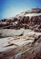
Funerary Temple of Hatshepsut, general view from the east
Image
uu_aah_art
44
Keet Seel, cliff ruins east middle branch of Sagy (Towanaoche) canyon, Ariz., 1910 (Photo G165)
1910
Image
uum_map
45
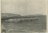
Section of the Shinarump Cliffs (middle distance), east of Pioneer Gap. Shinarump conglomerate exposed by erosion of Moenkopi formation below and the basal strata of the Chinle formation above. Upper Chinle sandstones form Vermilion Cliffs (background).
1944
Image
uum_map
46
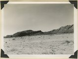
View looking east across Parunuweap Valley near Mt. Carmel. Distance Elkheart Cliffs (Navajo capped by Carmel) on upthrown side of Sevier fault; middle distance erosion surface in Carmel and other Jurassic. Kane County, Utah, 1932.
1934
Image
uum_map
47
Looking down Notch Canyon from East Point, Elk Ridge, toward Chimney Park. Cottonwood Canyon in middle distance. Buttes of Navajo beyond Shay Mountains in distance. San Juan County, UT, 1928
Image
uum_map
48
Looking down Notch Canyon from East Point, Elk Ridge, toward Chimney Park. Cottonwood Canyon in middle distance. Buttes of Navajo beyond Shay Mountains in distance. San Juan County, UT, 1928
1928
Image
uum_map
49
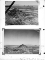
Panorama {a}. Flank of East Kaibab monocline, bordering alluvial floor of Paria Valley. Navajo sandstone (middle sky line), Upper Jurassic strata, and basal Cretaceous (left). Dips of 40 degrees decrease to 3 degrees within 1,000 feet. Kane County, UT, 1944
1944
Image
uum_map
50
Panorama {b}. Flank of East Kaibab monocline, bordering alluvial floor of Paria Valley. Navajo sandstone (middle sky line), Upper Jurassic strata, and basal Cretaceous (left). Dips of 40 degrees decrease to 3 degrees within 1,000 feet. Kane County, UT, 1944
1944
Image
uum_map
26
-
50
of
277
<
1
2
3
4
5
6
7
8
9
10
>