|
|
Title | Date | Type |
| 1 |
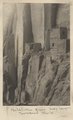
 |
"Sigh," the pack mule, 1910 (Photo N-M103) | 1910 | Image |
| 2 |
 |
"The Twins," LaPlata strata, Bluff, Utah, 1910 (Photo G134) | 1910 | Image |
| 3 |
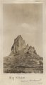 |
Agathla (John Wetherill photo) | 1910 | Image |
| 4 |
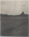 |
Agathla and Slim (Queen) Rock, Ariz., from S.E. (Photo G144) | 1910 | Image |
| 5 |
 |
Agathla and Slim (Queen) Rock, Ariz., from S.E. (Photo G144) | 1910 | Image |
| 6 |
 |
Agathla and Slim (Queen) Rock, Ariz., from S.E. (Photo N-M86) | 1910 | Image |
| 7 |
 |
Agathla, volcanic neck, between Chinlee, Ariz. and Oljato, Utah, 1910 (Photo G145) | 1910 | Image |
| 8 |
 |
Agathla, volcanic neck, between Chinlee, Ariz. and Oljato, Utah, 1910 (Photo G145) | 1910 | Image |
| 9 |
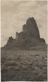 |
Agathla, volcanic neck, between Chinlee, Ariz. and Oljato, Utah, 1910 (Photo G146) | 1910 | Image |
| 10 |
 |
Agathla, volcanic neck, between Chinlee, Ariz. and Oljato, Utah, 1910 (Photo G146) | 1910 | Image |
| 11 |
 |
Agathla, volcanic neck, between Chinlee, Ariz. and Oljato, Utah, 1910 (same as G145, Townsend photo) | 1910 | Image |
| 12 |
 |
Barohoini Bridge, 1910 | 1910 | Image |
| 13 |
 |
Barohoini Bridge, 1910 | 1910 | Image |
| 14 |
 |
Barohoini Bridge, 1910 | 1910 | Image |
| 15 |
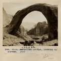
 |
Barohoini Bridge, looking downstream, i.e. northwest, 1910 (Photo G178A) | 1910 | Image |
| 16 |
 |
Barohoini Bridge, looking downstream, i.e. northwest, 1910 (Photo G178A) | 1910 | Image |
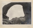
| 17 |
 |
Barohoini Bridge, looking upstream, 1910 | 1910 | Image |
| 18 |
 |
Barohoini Bridge, looking upstream, 1910 (Photo G179) | 1910 | Image |
| 19 |
 |
Barohoini Bridge, looking upstream, 1910 (Photo G179) | 1910 | Image |
| 20 |
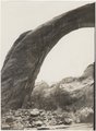 |
Barohoini Bridge, northeast arch, 1910 (Photo G180) | 1910 | Image |
| 21 |
 |
Barohoini Bridge, northeast arch, 1910 (Photo G180) | 1910 | Image |
| 22 |
 |
Barohoini Bridge, top of arch, 1910 (Photo N-M100) | 1910 | Image |
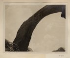
| 23 |
 |
Barohoini Natural Bridge, 10+ mi. northwest of Navajo Mt., Utah in LaPlata strata, 1910. Looking down stream northwest from distance of 1+ mi. (Photo G176) | 1910 | Image |
| 24 |
 |
Base of northeast arch of Barohoini Bridge, 1910 (Photo G182) | 1910 | Image |
| 25 |
 |
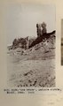
Betatakin Ruin, Sagy Canyon (Townsend photo) | 1910 | Image |