Home
Browse
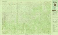
Ask Us
Chat
Harmful Language Statement
Log in
Advanced Search
Year
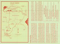
1850
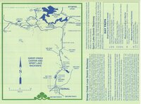
1851
1852
1853
1854
1855
1856
1857
1858
1859
1860
1861
1862
1863
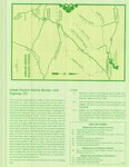
1864
1865
1866
1867
1868
1869
1870
1871
1872
1873
1874
1875
1876
1877
1878
1879
1880
1881
1882
1883
1884
1885
1886
1887
1888
1889
1890
1891
1892
1893
1894
1895
1896
1897
1898
1899
1900
1901
1902
1903
1904
1905
1906
1907
1908
1909
1910
1911
1912
1913
1914
1915
1916
1917
1918
1919
1920
1921
1922
1923
1924
1925
1926
1927
1928
1929
1930
1931
1932
1933
1934
1935
1936
1937
1938
1939
1940
1941
1942
1943
1944
1945
1946
1947
1948
1949
1950
1951
1952
1953
1954
1955
1956
1957
1958
1959
1960
1961
1962
1963
1964
1965
1966
1967
1968
1969
1970
1971
1972
1973
1974
1975
1976
1977
1978
1979
1980
1981
1982
1983
1984
1985
1986
1987
1988
1989
1990
1991
1992
1993
1994
1995
1996
1997
1998
1999
2000
2001
2002
2003
2004
2005
2006
2007
2008
2009
2010
2011
2012
2013
2014
2015
2016
2017
2018
2019
2020
2021
2022
2023
2024
TO
1850
1851
1852
1853
1854
1855
1856
1857
1858
1859
1860
1861
1862
1863
1864
1865
1866
1867
1868
1869
1870
1871
1872
1873
1874
1875
1876
1877
1878
1879
1880
1881
1882
1883
1884
1885
1886
1887
1888
1889
1890
1891
1892
1893
1894
1895
1896
1897
1898
1899
1900
1901
1902
1903
1904
1905
1906
1907
1908
1909
1910
1911
1912
1913
1914
1915
1916
1917
1918
1919
1920
1921
1922
1923
1924
1925
1926
1927
1928
1929
1930
1931
1932
1933
1934
1935
1936
1937
1938
1939
1940
1941
1942
1943
1944
1945
1946
1947
1948
1949
1950
1951
1952
1953
1954
1955
1956
1957
1958
1959
1960
1961
1962
1963
1964
1965
1966
1967
1968
1969
1970
1971
1972
1973
1974
1975
1976
1977
1978
1979
1980
1981
1982
1983
1984
1985
1986
1987
1988
1989
1990
1991
1992
1993
1994
1995
1996
1997
1998
1999
2000
2001
2002
2003
2004
2005
2006
2007
2008
2009
2010
2011
2012
2013
2014
2015
2016
2017
2018
2019
2020
2021
2022
2023
2024
Type
Text
317
Image
132
Image/StillImage
86
Sound
1
Format
application/pdf
345
image/jpeg
253
Collection
College of Nursing
25
College of Pharmacy
10
Department of City and Metropolitan P...
2
Eccles Health Sciences Library History
3
Electronic University Archive
23
Extractions from the Land: Mining and...
1
Gerontology Interdisciplinary Program
1
History of the Health Sciences
4
Illuminations
5
Lennox and Catherine Tierney Photogra...
1
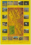
More Than A Flag: Utah State Flag Red...
108
Photo Archives
1
Regional History Center
1
School of Medicine Yearbooks
3
Theses & Dissertations
46
Topaz Museum
3
UAIDA Main Collection
4
UScholar Works
3
Uintah County Regional History Center...
83
Utah Historical Society Oral History ...
1
Utah Medical Association Bulletin
63
Utah Nurse
31
Utah Pharmacy Digest
88
Utah River Running Photo Archives
61
Utah State Board Of Regents
5
Vernal Express Photographs
1
Water Wise Utah
11
Western Soundscape Spectrograms
12
More
Filters:
Subject:
"Utah"
1
-
25
of
600
<
1
2
3
4
5
6
7
8
9
10
>
Gallery view
Number of results to display per page
10
25
50
100
200
Sort by Relevance
Sort by Title A-Z
Sort by Title Z-A
Sort by Date Ascending
Sort by Date Descending
Sort by Last Modified Ascending
Sort by Last Modified Descending
Title
Date
Type
Setname
1
Westwater, Utah-Colorado 1981
1980; 1981
Image/StillImage
ucl_maps
2
Seep Ridge, Utah-Colorado 1982
1981; 1982
Image/StillImage
ucl_maps
3
Seep Ridge, Utah 1999
1999
Image/StillImage
ucl_maps
4
Bonneville Fuels Corp - Wolf Point Pipeline Project - Uintah County, Utah - Project Site Map
Image/StillImage
ucl_maps
5
Geologic Map of Uintah County, Utah - South Half - 1950s
1950; 1951; 1952; 1953; 1954; 1955; 1956; 1957; 1958; 1959
Image/StillImage
ucl_maps
6
Dinosaurland One-Day Self-Guided Tour #9 Indian Canyon
Image/StillImage
ucl_maps
7
Seep Ridge, Utah-Colorado 1981
1981
Image/StillImage
ucl_maps
8
Dinosaurland One-Day Self-Guided Tour #6 Outlaw Country - Crouse Canyon, Brown's Park, Javie's Ranch, Jessie Ewing Canyon
Image/StillImage
ucl_maps
9
Dinosaurland One-Day Self-Guided Tour #8 Sheep Creek Canyon and Spirit Lake
Image/StillImage
ucl_maps
10
Snow Canyon State Park (Brochure and Map)
Image/StillImage
ucl_maps
11
Leaving Mystery Canyon.
1957; 1958; 1959; 1960; 1961; 1962
uum_map_rr
12
Leaving Mystery Canyon.
1957; 1958; 1959; 1960; 1961; 1962
uum_map_rr
13
Leaving Mystery Canyon.
1957; 1958; 1959; 1960; 1961; 1962
uum_map_rr
14
Leaving Mystery Canyon.
1957; 1958; 1959; 1960; 1961; 1962
uum_map_rr
15
Observations and modeling of thermally driven wind jets at the exit of a Utah canyon
2011-12
Text
ir_etd
16
Jessilie's Wailing Wall.
1957; 1958; 1959; 1960; 1961; 1962
uum_map_rr
17
"Sentinel Rock at Wahweap [Canyon]. 16 miles more to go."
1951-05
uum_map_rr
18
Dinosaurland One-Day Self-Guided Tour #2 Indian Petroglyphs Dry Fork Canyon
Image/StillImage
ucl_maps
19
The geology and erosional development Northern Bryce Canyon National Park
1961
Text
ir_etd
20
Index To Geologic Atlas of Utah - Daggett County - 1950s
1950; 1951; 1952; 1953; 1954; 1955; 1956; 1957; 1958; 1959
Image/StillImage
ucl_maps
21
Energy resources map of Utah (no. 68)
1983-05
Text
ir_eua
22
Dinosaurland One-Day Self-Guided Tour #3 Red Cloud Loop Scenic Byway
Image/StillImage
ucl_maps
23
Red Canyon
1961-08-10
Image
ucl_vep
24
"Lunch stop on SW bank of Colorado River at mile 9.5"
1951-05-17
uum_map_rr
25
"NE from M Hidden Passage Redbud Canyon. Traveling in Music Temple."
1951-05
uum_map_rr
1
-
25
of
600
<
1
2
3
4
5
6
7
8
9
10
>