TO
1 - 25 of 17
| Author | Title | Subject | Date | Publication Type | ||
|---|---|---|---|---|---|---|
| 1 |
 |
Brooke, John Percival | Alteration and trace elements of volcanics in the San Francisco Mountains | Mineralogy; Utah; Beaver County; Geochemistry; Ore deposits; Thesis and dissertation georeferencing project | 1964-06 | thesis |
| 2 |
 |
Brooke, John Percival | Alteration and trace elements of volcanics in the San Francisco Mountains: Georeferenced map files | Thesis and dissertation georeferencing project | 1964-06 | thesis |
| 3 |
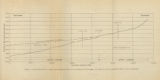 |
Gates, Joseph S. | Figure 4: Longitudinal profile of Middle Canyon showing locations of the profiles across the canyon, the nickpoint, and the hypothetical profile before rejuvenation | Thesis and dissertation georeferencing project | 1960-08 | thesis |
| 4 |
 |
Doyuran, Vedat | Geology and ground-water resources of Ogden Valley, Utah | Geology -- Utah -- Ogden Valley; Groundwater -- Utah -- Ogden Valley; Thesis and dissertation georeferencing project | 1972-06 | thesis |
| 5 |
 |
Zimmerman, James T. | Geology of the Cove Creek area Millard County and Beaver County, Utah | Geology; Utah; Cove Creek area; Thesis and dissertation georeferencing project | 1961-06 | thesis |
| 6 |
 |
Harrill, James Reece | Geology of the Davis Knolls and northern Big Davis Mountain area, Tooele County, Utah | Geology -- Utah -- Tooele County; Thesis and dissertation georeferencing project | 1962-08 | thesis |
| 7 |
 |
Egbert, Robert L. | Geology of the East Canyon area, Morgan County, Utah | Geology -- Utah -- Morgan County; Thesis and dissertation georeferencing project | 1954 | thesis |
| 8 |
 |
Madsen, James Henry Jr. | Geology of the Lost Creek-Echo Canyon Area, Morgan and Summit Counties, Utah | Geology -- Utah -- Morgan County; Geology -- Utah -- Summit County; Thesis and dissertation georeferencing project | 1959-06 | thesis |
| 9 |
 |
Cohenour, Robert E. | Geology of the Sheeprock Mountains, Tooele and Juab Counties, Utah | Geology -- Utah -- Sheeprock Mountains; Geology -- Utah -- Tooele County; Geology -- Utah -- Juab County; Thesis and dissertation georeferencing project | 1957-08 | thesis |
| 10 |
 |
Root, Robert L. | Geology of the Smith and Morehouse-Hayden Fork area, Utah | Geology; Utah; Summit County; Thesis and dissertation georeferencing project | 1952 | thesis |
| 11 |
 |
Gardner, Weston Clive | Geology of the West Tintic mining district and vicinity, Juab County, Utah | Geology -- Utah -- Juab County -- Tintic Mining District; Thesis and dissertation georeferencing project | 1954-06 | thesis |
| 12 |
 |
Amin, Surendra R. | Map 1: Geologic map of Antelope intrusive and vicinity (Google Earth map overlay KMZ file) | Thesis and dissertation georeferencing project | 1950 | map |
| 13 |
|
Dalness, William Michael | Parunuweap formation in the vicinity of Zion National Park, Utah (Google Earth map overlay KMZ file) | Thesis and dissertation georeferencing project | 1969-06 | map |
| 14 |
 |
Vlam, Heber Adolf Arien | Petrology of Lake Bonneville Gravels Salt Lake County, Utah | Petrology; Utah; Salt Lake County; Bonneville; Thesis and dissertation georeferencing project | 1963-05 | thesis |
| 15 |
|
Blue, Donald McCoy | Plate 1: Lucin mining district and vicinity, Northern Pilot Range, Box Elder County, Utah - Elko County, Nevada (Google Earth map overlay KMZ file) | Thesis and dissertation georeferencing project | 1960-08 | thesis |
| 16 |
|
Schaeffer, Jr. Frederick Ernst | Plate 1B: Geologic map of the Central and Southern Silver Island Mountains, Box Elder and Tooele Counties, Utah, and Elko County, Nevada (Google Earth map overlay KMZ file) | Thesis and dissertation georeferencing project | 1961-06 | thesis |
| 17 |
 |
Winkler, Gary Ralphs | Sedimentology and geomorphic significance of the bishop conglomerate and the Browns Park Formation, Eastern Uinta Mountains, Utah, Colorado, And Wyoming (Thesis and maps) | Sediments (Geology); Uinta Mountains; Structural; Stratigraphic; Tertiary; Thesis and dissertation georeferencing project | 1970-06 | thesis |
1 - 25 of 17