Home
Browse
Ask Us
Chat
Harmful Language Statement
Log in
Advanced Search
Year
1849
1850
1851
1852
1853
1854
1855
1856
1857
1858
1859
1860
1861
1862
1863
1864
1865
1866
1867
1868
1869
1870
1871
1872
1873
1874
1875
1876
1877
1878
1879
1880
1881
1882
1883
1884
1885
1886
1887
1888
1889
1890
1891
1892
1893
1894
1895
1896
1897
1898
1899
1900
1901
1902
1903
1904
1905
1906
1907
1908
1909
1910
1911
1912
1913
1914
1915
1916
1917
1918
1919
1920
1921
1922
1923
1924
1925
1926
1927
1928
1929
1930
1931
1932
1933
1934
1935
1936
1937
1938
1939
1940
1941
1942
1943
1944
1945
1946
1947
1948
1949
1950
1951
1952
1953
1954
1955
1956
1957
1958
1959
1960
1961
1962
1963
1964
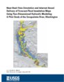
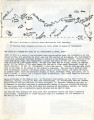
1965
1966
1967
1968
1969
1970
1971
1972
1973
1974
1975
1976
1977
1978
1979
1980
1981
1982
1983
1984
1985
1986
1987
1988
1989
1990
1991
1992
1993
1994
1995
1996
1997
1998
1999
2000
2001
2002
2003
2004
2005
2006
2007
2008
2009
2010
2011
2012
2013
2014
2015
2016
2017
2018
2019
TO
1849
1850
1851
1852
1853
1854
1855
1856
1857
1858
1859
1860
1861
1862
1863
1864
1865
1866
1867
1868
1869
1870
1871
1872
1873
1874
1875
1876
1877
1878
1879
1880
1881
1882
1883
1884
1885
1886
1887
1888
1889
1890
1891
1892
1893
1894
1895
1896
1897
1898
1899
1900
1901
1902
1903
1904
1905
1906
1907
1908
1909
1910
1911
1912
1913
1914
1915
1916
1917
1918
1919
1920
1921
1922
1923
1924
1925
1926
1927
1928
1929
1930
1931
1932
1933
1934
1935
1936
1937
1938
1939
1940
1941
1942
1943
1944
1945
1946
1947
1948
1949
1950
1951
1952
1953
1954
1955
1956
1957
1958
1959
1960
1961
1962
1963
1964
1965
1966
1967
1968
1969
1970
1971
1972
1973
1974
1975
1976
1977
1978
1979
1980
1981
1982
1983
1984
1985
1986
1987
1988
1989
1990
1991
1992
1993
1994
1995
1996
1997
1998
1999
2000
2001
2002
2003
2004
2005
2006
2007
2008
2009
2010
2011
2012
2013
2014
2015
2016
2017
2018
2019
Type
Image/StillImage
80
Text
73
Image
37
Format
image/jpeg
102
application/pdf
80
application/xml
3
application/zip
3
Collection
Aziz Suryal Atiya papers
5
Beckwith Photograph Collection
8
Classified Photographs
10
Clifton Bray Film Negatives
10
Extractions from the Land: Mining and...
2
Marriott Library Digital Stacks
1
Olympic Legacy
5
Peoples of Utah Revisited
4
Photo Archives
5
Salt Lake Tribune Negative Collection
14
Shipler Collection Negative Preservat...
18
Shipler Commercial Photographers
6
Ski and Snow Sports Archives
1
UAIDA Main Collection
92
Vernal Express Photographs
2
Western Waters Electronic Resources
4
Westminster University Finding Aids (...
3
More
Filters:
Subject:
"Maps"
Year End:
2016
101
-
125
of
190
<
1
2
3
4
5
6
7
8
>
Gallery view
Number of results to display per page
10
25
50
100
200
Sort by Relevance
Sort by Title A-Z
Sort by Title Z-A
Sort by Date Ascending
Sort by Date Descending
Sort by Last Modified Ascending
Sort by Last Modified Descending
Title
Date
Type
Setname
101
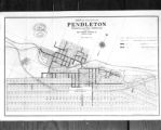
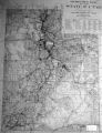
M.L. Gordon, Copy of Map of City of Pendleton, Ore.
1922-02-15
Image/StillImage
dha_scnpp
102
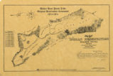
Map of a portion of the Uncompahgre Ute Indian Reservation
1908
Image/StillImage
uaida_main
103
Map of a portion of the Uncompahgre Ute Indian Reservation, surveyed and subdivided for allotments to the Uncompahgre Ute Indians in accordance with the Act approved June 1880 by authority of Honorable N. C. McFarland, Commissioner General Land Office Daniel G. Major U.S. Surveyor 1882-1883
1882; 1883
Image/StillImage
uaida_main
104
Map of Reservations of the Western United States and the Religions that Worked on the Reservations 1870's
1873
Image/StillImage
uaida_main
105
Map of Utah with Cross
1951-10-18
Image
dha_scp
106
Map of Ute Reservation in Western Colorado, and Lands Ceded Over Time
1882
Image/StillImage
uaida_main
107
Map of Walker River Paiute Tribe Original Reservation Centennial 1874-1974
1874
Image/StillImage
uaida_main
108
Map on Wall at Walgreen Drug Store, May 1936
1936-05-28
Image
dha_cbfm
109
Map on Wall at Walgreen Drug Store, May 1936
1936-05-28
Image
dha_cbfm
110
Map showing the boundary of the Shoshone Indian territory
1941
Image/StillImage
uaida_main
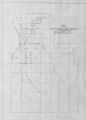
111
Map, [ca. 1953]
1953
Text
uaida_main
112
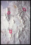
Map, annotated
1975
Image
dha_eftl
113
Map, July 1938
1938-07-12
Image
dha_cbfm
114
Map, July 1938
1938-07-12
Image
dha_cbfm
115
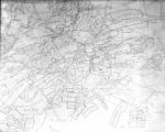
Map, Mar. 1938
1938-03-03
Image
dha_cbfm
116
Map, Mar. 1938
1938-03-03
Image
dha_cbfm
117
Map, Mar. 1938
1938-03-03
Image
dha_cbfm
118
Map, May 1938
1938-05-16
Image
dha_cbfm
119
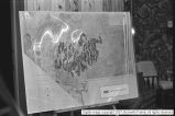
Map, Salt Lake Valley
1975
Image
dha_eftl
120
MX Missile meetings [12]
1981
Image
dc_bpc
121
N.A. Dunyon, Copy of Section of Map
1923-03-03
Image/StillImage
dha_scnpp
122
Naval Supply Depot, Clearfield P.20
1950; 1951; 1952; 1953; 1954; 1955; 1956; 1957; 1958; 1959; 1960; 1961; 1962; 1963
Image/StillImage
dha_cp
123
Naval Supply Depot, Clearfield P.21
1962
Image/StillImage
dha_cp
124
Near-real-time simulation and internet-based delivery of forecast-flood inundation maps using two-dimensional hydraulic modeling: a pilot study of the Snoqualmie River, Washington
2002
Text
wwdl_er
125
Notes from St. Christopher's Mission, 1940's
1940; 1941; 1942; 1942; 1943; 1944; 1945; 1946; 1947; 1948; 1949
Text
uaida_main
101
-
125
of
190
<
1
2
3
4
5
6
7
8
>