|
|
Title | Date | Type | Setname |
| 101 |
 |
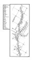
Colorado River -- Excursions p.14 | 1935; 1936; 1937; 1938; 1939; 1940; 1941; 1942; 1943; 1944; 1945 | Image/StillImage | dha_cp |
| 102 |
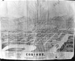 |
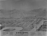
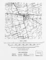
Corinne, Utah P.1 | | Image | dha_cp |
| 103 |
 |
Cottonwood Mining District P.1 | | Image | dha_cp |
| 104 |
 |
David Stanley Westminster College faculty member's papers | 1991; 1992; 1993; 1994; 1995; 1996; 1997; 1998; 1999; 2000; 2001; 2002; 2003; 2004; 2005; 2006; 2007; 2008 | | wc_ead |
| 105 |
 |
Dept. of Int. Indian Irrigation Service, Copy of Blue Print, Blackfoot River & Gray Lake Dev. | 1921-06-18 | Image/StillImage | dha_scnpp |
| 106 |
 |
Dinosaur National Monument | 1958-05-29 | Image | ucl_vep |
| 107 |
 |
Dr.S.H. Goodwin | 1926-08-09 | Image/StillImage | dha_scnpp |
| 108 |
 |
Dry Canyon Ophir Mining District P.1 | | Image | dha_cp |
| 109 |
 |
Dura Europos, general site plan | | Image | uu_aah_art |
| 110 |
 |
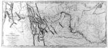
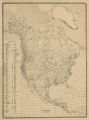
Early Roads and Railroads circa 1895 | | Image/StillImage | uaida_main |
| 111 |
 |
Echo Canyon P.1 | | Image | dha_cp |
| 112 |
 |
Echo Canyon P.2 | | Image | dha_cp |
| 113 |
 |
Echo Canyon P.3 | | Image | dha_cp |
| 114 |
 |
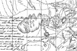
El Palacio, volume 30, nos.19-20 (May 20, 1931) [02]: Map, Nine Mile Canyon | 1931-05-20 | Image | dc_bpc |
| 115 |
 |
Emigrant Road from Independence to San Fran. P.1 | | Image | dha_cp |
| 116 |
 |
Escalante Map P.1 | | Image | dha_cp |
| 117 |
 |
Escalante Route Map P.1 | | Image | dha_cp |
| 118 |
 |
Escalante Valley Improvement Company Map | 1915-11-19 | Image | dha_scp |
| 119 |
 |
Escalante, Utah--Map P.1 | | Image | dha_cp |
| 120 |
 |
F.B. Cook | 1936-05-20 | Image/StillImage | dha_scnpp |
| 121 |
 |
F.J. Salathe Jr., Copy of Section of Map | 1928-09-01 | Image/StillImage | dha_scnpp |
| 122 |
 |
Father Escalante's Map | 1941 | Text | uaida_main |
| 123 |
 |
Field Notes from Survey of Uintah Reservation | 1875-09-25 | Text | uaida_main |
| 124 |
 |
Ford Motor CO. | 1925-08-13 | Image/StillImage | dha_scnpp |
| 125 |
 |
Ford Motor CO. | 1925-08-13 | Image/StillImage | dha_scnpp |
| 126 |
 |
Fort Bridger P.1 | | Image | dha_cp |
| 127 |
 |
Fort Douglas Utah Territory P.1 | | Image | dha_cp |
| 128 |
|
Frederick G. Burton Presbyterian Church in Utah research collection, 1871-2006 (bulk 1871-1951) | 1871; 1872; 1873; 1874; 1875; 1876; 1877; 1878; 1879; 1880; 1881; 1882; 1883; 1884; 1885; 1886; 1887; 1888; 1889; 1890; 1891; 1892; 1893; 1894; 1895; 1896; 1897; 1898; 1899; 1900; 1901; 1902; 1903; 1904; 1905; 1906; 1907; 1908; 1909; 1910; 1911; 1912; 1913; 1914; 1915; 1916; 1917; 1918; 1919; 1920; ... | | wc_ead |
| 129 |
 |
Fur Traders' Route (Peter Skene Ogden) P.1 | | Image | dha_cp |
| 130 |
 |
The Ghost dance Religion and the Sioux | | Text | uaida_main |
| 131 |
 |
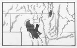
Goshute Indian Reservation Nevada and Utah | | Image/StillImage | uaida_main |
| 132 |
 |
Goshute Skull Valley Reservation Geothermal Resources Map | 2004-01-14 | Image/StillImage | uaida_main |
| 133 |
 |
Great Salt Lake P.1 | | Image | dha_cp |
| 134 |
 |
Great Salt Lake P.2 | | Image | dha_cp |
| 135 |
 |
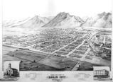
Great Salt Lake City P.1 | | Image | dha_cp |
| 136 |
 |
Great Salt Lake--Ferris P.1 | | Image | dha_cp |
| 137 |
 |
Great Salt Lake--Trails of Charles Stoddard P.1 | | Image | dha_cp |
| 138 |
 |
The Green & Colorado Rivers P.1 | | Image | dha_cp |
| 139 |
 |
Ground-water data for the Warm Springs Indian Reservation and contiguous areas, north-central Oregon | 1996 | Text | wwdl_er |
| 140 |
 |
Gunnison Massacre [19] : Map accompanying a transcript of part of Josiah Gibbs' account, from "Lights and Shadows of Mormonism" (1909), pp. 176-189 | 1926 | Image | dc_bpc |
| 141 |
 |
Gunnison Massacre--Site P.1 | | Image | dha_cp |
| 142 |
 |
Harrisburg Mining District P.1 | | Image | dha_cp |
| 143 |
 |
Hastings Cutoff--Map P.1 | | Image | dha_cp |
| 144 |
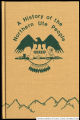 |
History of the Northern Ute People, A | 1982 | Text | uaida_main |
| 145 |
 |
Host City map of downtown | 2002 | Image | dha_olyleg |
| 146 |
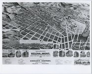 |
Illustrated map of Helena, Montana | 1890 | Image/StillImage | uum_map |
| 147 |
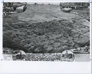 |
Illustrated map of Phoenix, Arizona | 1886; 1887; 1888; 1889; 1890; 1891; 1892; 1893; 1894; 1895; 1896; 1897; 1898; 1899; 1900; 1901; 1902; 1903; 1904; 1905; 1906; 1907; 1908; 1909; 1910 | Image/StillImage | uum_map |
| 148 |
 |
Illustrated map of Prescott, Arizona Territory | 1886; 1887; 1888; 1889; 1890; 1891; 1892; 1893; 1894; 1895; 1896; 1897; 1898; 1899; 1900; 1901; 1902; 1903; 1904; 1905; 1906; 1907; 1908; 1909; 1910 | Image/StillImage | uum_map |
| 149 |
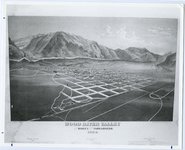 |
Illustrated map of Wood River Valley, Idaho | 1884 | Image/StillImage | uum_map |
| 150 |
 |
Indian Names in Utah Geography | 1928; 1929; 1930; 1931; 1932; 1933 | Text | uaida_main |
| 151 |
 |
Information about the Middle East Library, Univ. of Utah, and its holdings. | 1977 | Text | uum_asap |
| 152 |
 |
Int. Smelting Company | 1932-03-26 | Image/StillImage | dha_scnpp |
| 153 |
 |
Int. Smelting Company | 1932-03-26 | Image/StillImage | dha_scnpp |
| 154 |
 |
J.E. Himes, Copy of Fifth Page of Letter (Map) | 1929-07-11 | Image/StillImage | dha_scnpp |
| 155 |
 |
Jas. Invers, Copy of Blue Print | 1922-02-28 | Image/StillImage | dha_scnpp |
| 156 |
 |
Jeremy Ranch--Map P.1 | | Image | dha_cp |
| 157 |
 |
Joe's grandfather, Leo Frazier scrapbook | 1985 | Image; Text | dha_pour |
| 158 |
 |
Johnston's Army P.1 | | Image | dha_cp |
| 159 |
 |
Jordan River Map of Beautification -Shot 1 | 1939-06 | Image/StillImage | dha_sltnc |
| 160 |
 |
Jordan River Map of Beautification -Shot 2 | 1939-06 | Image/StillImage | dha_sltnc |
| 161 |
 |
Journal of Two Campaigns by the Utah Territorial Militia Against the Navajo Indians, 1869 | 1961 | Text | uaida_main |
| 162 |
 |
Kanosh, Black Rock, Pumice and Connor Spring scrapbook [02] : Kanosh mounds inside cover | 1930 | Image | dc_bpc |
| 163 |
 |
Kanosh, Black Rock, Pumice and Connor Spring scrapbook [03] : Kanosh mounds | 1930 | Image | dc_bpc |
| 164 |
 |
Kirtland, Ohio P.1 | | Image | dha_cp |
| 165 |
 |
Kirtland, Ohio P.2 | | Image | dha_cp |
| 166 |
 |
Lake Bonneville P.1 | | Image | dha_cp |
| 167 |
 |
Lake Bonneville P.2 | | Image | dha_cp |
| 168 |
 |
Land Added to Confederated Ute Indian Reservation 1875-76 | | Text | uaida_main |
| 169 |
 |
Land Allotments, White Mesa | | Image/StillImage | uaida_main |
| 170 |
 |
Land Use--Map P.1 | | Image | dha_cp |
| 171 |
 |
Lepcis Magna, plan | | Image | uu_aah_art |
| 172 |
 |
Letter from Agent Byrnes to Commissioner of Indian Affairs John D.C. Atkins dated November 28, 1887 | 1887-11-28 | Text | uaida_main |
| 173 |
 |
Letter from Agent Robert Waugh to Commissioner of Indian Affairs T.J. Morgan dated July 30, 1892 | 1892-07-30 | Text | uaida_main |
| 174 |
 |
Letter from Brigham Young to the Commissioner of Indian Affairs dated June 28, 1853 | 1853-06-28 | Text | uaida_main |
| 175 |
 |
Letter to Commissioner of Indian Affairs J.T. Morgan from Agent Robert Waugh dated March 28, 1892 | 1892-03-28 | Text | uaida_main |
| 176 |
 |
Lewis & Clark Trail P.1 | | Image | dha_cp |
| 177 |
 |
Lewis & Clark Trail P.2 | | Image | dha_cp |
| 178 |
 |
Little Cottonwood Canyon Mining District P.1 | | Image | dha_cp |
| 179 |
 |
Logan, Utah (Birdseye View) P.1 | | Image | dha_cp |
| 180 |
 |
Lucin Cut-off P.1 | | Image | dha_cp |
| 181 |
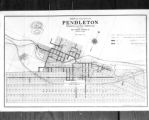 |
M.L. Gordon, Copy of Map of City of Pendleton, Ore. | 1922-02-15 | Image/StillImage | dha_scnpp |
| 182 |
 |
Map based on Bunyan's "Pilgrim's Progress" | | Image | uu_aah_art |
| 183 |
 |
Map of a portion of the Uncompahgre Ute Indian Reservation | 1908 | Image/StillImage | uaida_main |
| 184 |
 |
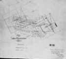
Map of a portion of the Uncompahgre Ute Indian Reservation, surveyed and subdivided for allotments to the Uncompahgre Ute Indians in accordance with the Act approved June 1880 by authority of Honorable N. C. McFarland, Commissioner General Land Office Daniel G. Major U.S. Surveyor 1882-1883 | 1882; 1883 | Image/StillImage | uaida_main |
| 185 |
 |
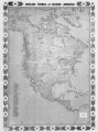
Map of America | | Image | uu_aah_art |
| 186 |
 |
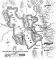
Map of Chief Washakie's Hunting and Fighting Territory, prepare by Oscar Mosserly, 1930 | | Image/StillImage | uaida_main |
| 187 |
 |
Map of Constantinople | | Image | uu_aah_art |
| 188 |
 |
Map of Dry Gulch Irrigation District, Uintah Indian Reservation, Utah | | Image/StillImage | uaida_main |
| 189 |
 |
Map of Dutch East India Company (V.O.C.) Trade Routes | | Image | uu_aah_art |
| 190 |
 |
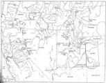
Map of East Central Utah, Uintah Ouray Reservation, Utah Valley | | Image/StillImage | uaida_main |
| 191 |
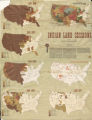 |
Map of Indian Land Cessions in the United States | | Image/StillImage | uaida_main |
| 192 |
 |
Map of Indian Reservation in the West, 1929 | | Image/StillImage | uaida_main |
| 193 |
 |
Map of Indian Reservation. 1884 | | Image/StillImage | uaida_main |
| 194 |
 |
Map of Indian Reservations in the Western United States | | Image/StillImage | uaida_main |
| 195 |
 |
Map of Indian Territory in the Western United States | | Image/StillImage | uaida_main |
| 196 |
 |
Map of Indian Tribes of North America | | Image/StillImage | uaida_main |
| 197 |
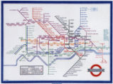 |
Map of London Underground, After Re-Design | | Image | uu_aah_art |
| 198 |
 |
Map of Navajo, Ute, and Jicarilla Apache Indian Reserves | | Image/StillImage | uaida_main |
| 199 |
 |
Map of North America and Original Inhabitants' Territory. | | Image/StillImage | uaida_main |
| 200 |
 |
Map of Northern Utah, Early Settlements | | Image/StillImage | uaida_main |