Home
Browse
Ask Us
Chat
Harmful Language Statement
Log in
Advanced Search
Year
1849
1850
1851
1852
1853
1854
1855
1856
1857
1858
1859
1860
1861
1862
1863
1864
1865
1866
1867
1868
1869
1870
1871
1872
1873
1874
1875
1876
1877
1878
1879
1880
1881
1882
1883
1884
1885
1886
1887
1888
1889
1890
1891
1892
1893
1894
1895
1896
1897
1898
1899
1900
1901
1902
1903
1904
1905
1906
1907
1908
1909
1910
1911
1912
1913
1914
1915
1916
1917
1918
1919
1920
1921
1922
1923
1924
1925
1926
1927
1928
1929
1930
1931
1932
1933
1934
1935
1936
1937
1938
1939
1940
1941
1942
1943
1944
1945
1946
1947
1948
1949
1950
1951
1952
1953
1954
1955
1956
1957
1958
1959
1960
1961
1962
1963
1964
1965
1966
1967
1968
1969
1970
1971
1972
1973
1974
1975
1976
1977
1978
1979
1980
1981
1982
1983
1984
1985
1986
1987
1988
1989
1990
1991
1992
1993
1994
1995
1996
1997
1998
1999
2000
2001
2002
2003
2004
2005
2006
2007
2008
2009
2010
2011
2012
2013
2014
2015
2016
2017
2018
2019
TO
1849
1850
1851
1852
1853
1854
1855
1856
1857
1858
1859
1860
1861
1862
1863
1864
1865
1866
1867
1868
1869
1870
1871
1872
1873
1874
1875
1876
1877
1878
1879
1880
1881
1882
1883
1884
1885
1886
1887
1888
1889
1890
1891
1892
1893
1894
1895
1896
1897
1898
1899
1900
1901
1902
1903
1904
1905
1906
1907
1908
1909
1910
1911
1912
1913
1914
1915
1916
1917
1918
1919
1920
1921
1922
1923
1924
1925
1926
1927
1928
1929
1930
1931
1932
1933
1934
1935
1936
1937
1938
1939
1940
1941
1942
1943
1944
1945
1946
1947
1948
1949
1950
1951
1952
1953
1954
1955
1956
1957
1958
1959
1960
1961
1962
1963
1964
1965
1966
1967
1968
1969
1970
1971
1972
1973
1974
1975
1976
1977
1978
1979
1980
1981
1982
1983
1984
1985
1986
1987
1988
1989
1990
1991
1992
1993
1994
1995
1996
1997
1998
1999
2000
2001
2002
2003
2004
2005
2006
2007
2008
2009
2010
2011
2012
2013
2014
2015
2016
2017
2018
2019
Type
Image
270
Image/StillImage
181
Text
83
Format
image/jpeg
413
application/pdf
113
application/xml
3
application/zip
3
Collection
Art and Art History
169
Aziz Suryal Atiya papers
5
Beckwith Photograph Collection
8
Classified Photographs
62
Clifton Bray Film Negatives
10
Extractions from the Land: Mining and...
2
Marriott Library Digital Stacks
1
Olympic Legacy
5
Peoples of Utah Revisited
6
Photo Archives
12
Salt Lake Tribune Negative Collection
14
Shipler Collection Negative Preservat...
18
Shipler Commercial Photographers
6
Ski and Snow Sports Archives
1
UAIDA Main Collection
201
Vernal Express Photographs
2
Western Waters Electronic Resources
4
Westminster University Finding Aids (...
3
Westminster University Photographs
5
More
Filters:
Subject:
"Maps"
Setname:
!(ir* OR ehsl*)
451
-
475
of
534
<
13
14
15
16
17
18
19
20
21
22
>
Gallery view
Number of results to display per page
10
25
50
100
200
Sort by Relevance
Sort by Title A-Z
Sort by Title Z-A
Sort by Date Ascending
Sort by Date Descending
Sort by Last Modified Ascending
Sort by Last Modified Descending
Title
Date
Type
Setname
451
Salt Lake City, City and County Building P.55
1916-08-02
Image/StillImage
dha_cp
452
Salt Lake County--Maps Traffic Accidents
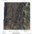
1939-09
Image/StillImage
dha_sltnc
453
Samuel McIntyre, Copy of Map
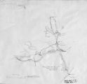
1930-05-23
Image/StillImage
dha_scnpp
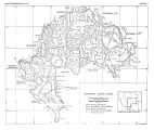
454
Scenic Overlook Display
1958-07-10
Image
ucl_vep
455
The Seasonal Movements of the Shoshone-Bannock Peoples
Image/StillImage
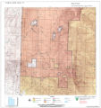
uaida_main
456
Selected mining districts of Utah
2005
Text
uum_mlds_public
457
Set 7 of undated correspondence written in Arabic
1958
Text
uum_asap
458
Shoshone Bannock/ Northwestern Soshone Reservations Geothermal Resource Map
2004-01-14
Image/StillImage
uaida_main
459
Sketch of Uintah Ouray Agencies.
Image/StillImage
uaida_main
460
Southern Paiute Bands
Image/StillImage
uaida_main
461
St. Christopher's Newsletter dated June 1973
1973
Text
uaida_main
462
State Maps
Image/StillImage
uaida_main
463
Surface Management Responsibility_001
Image/StillImage
uaida_main
464
Surface Management Responsibility_002
Image/StillImage
uaida_main
465
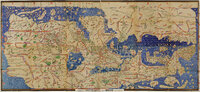
Tabula Rogeriana
Image
uu_aah_art
466
Telegraph from Nevada Territorial Governor J.W. Nye to Superintendent Doty dtd January 24, 1862
1862-01-24
Text
uaida_main
467
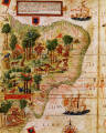
Terra Brasilis (detail)
Image
uu_aah_art
468
Third Annual Report of the Board of Indian Commissioners
1872
Image/StillImage
uaida_main
469
Tintic War 1856
Image/StillImage
uaida_main
470
Township 12th South, Range 19th West, Salt Lake Meridian_001
Image/StillImage
uaida_main
471
Township 12th South, Range 19th West, Salt Lake Meridian_002
Image/StillImage
uaida_main
472
Township 12th South, Range 19th West, Salt Lake Meridian_003
Image/StillImage
uaida_main
473
Township 12th South, Range 19th West, Salt Lake Meridian_004
Image/StillImage
uaida_main
474
Township 13th South, Range 19th West, Salt Lake Meridian_001
Image/StillImage
uaida_main
475
Township 13th South, Range 19th West, Salt Lake Meridian_002
Image/StillImage
uaida_main
451
-
475
of
534
<
13
14
15
16
17
18
19
20
21
22
>