|
|
Title | Creator | Creation Date |
| 1 |
 |
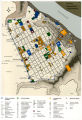
A Plan of the Town of New Haven with all the Buildings in 1748 | William Lyon | 1748 CE |
| 2 |
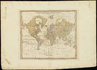 |
A chart of the world upon Mercator's projection : describing the tracks of Capt. Cook in the year 1768, 69, 70, 71, and in 1772, 73, 74, 75, with the new discoveries | William Faden | 1775 CE |
| 3 |
 |
A new plan of ye great town of Boston in New England in America, with the many additionall [sic] buildings, & new streets, to the year, 1769 | William Price; John Bonner | 1769 CE |
| 4 |
 |
Americae sive Novi Orbis, Noca Descripto (A New Description of America or the New World) | Abraham Ortelius | 1570 CE |
| 5 |
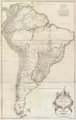 |
Amerique Meridionale Publiee sous les Auspices de Monseigneur le Duc d'Orleans | Jean Baptiste Bourguignon D'Anville | 1748 CE |
| 6 |
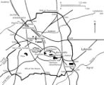 |
Athens, Greece, plan | | later 5th century BCE |
| 7 |
 |
Atlas of Maritime Charts (The Catalan Atlas) | possibly Abraham Cresques | 1375 CE |
| 8 |
 |
Atlas of Maritime Charts (The Catalan Atlas), detail showing Mansa Musa | possibly Abraham Cresques | 1375 CE |
| 9 |
 |
Boston, its environs and harbour, with the rebels works raised against that town in 1775 | Thomas Hyde Page | c. 1775 CE |
| 10 |
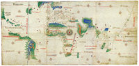 |
Cantino Planisphere | unknown | 1502 CE |
| 11 |
 |
Dura Europos, general site plan | | ca. 232 - 256 CE, town destroyed ca. 256 CE; rediscovered 1932 |
| 12 |
 |
Lepcis Magna, plan | | |
| 13 |
 |
Map based on Bunyan's "Pilgrim's Progress" | W. Jeffreys | c. 1800 CE |
| 14 |
 |
Map of America | attributed to Diogo Ribeiro | c. 1532 CE |
| 15 |
 |
Map of Constantinople | Cristoforo Buondelmonti | 1420 CE |
| 16 |
 |
Map of Dutch East India Company (V.O.C.) Trade Routes | | |
| 17 |
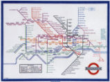 |
Map of London Underground, After Re-Design | Henry C. Beck | ca. 1933 CE |
| 18 |
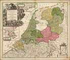 |
Map of the Dutch Republic | | 17th Century CE |
| 19 |
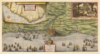 |
Map of the Dutch capture of the town of Olinda in Pernambuco by the Dutch West Indies Company in February 1630 | | 1630 CE |
| 20 |
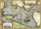 |
Map of the Pacific | Abraham Ortelius | 1589 CE |
| 21 |
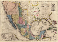 |
Map of the United States of Méjico (Mexico) | John Disturnell | 1846 CE |
| 22 |
 |
Map showing Ravenna and Aachen | | |
| 23 |
 |
Map showing the dissolution of the former Roman Empire, c. 600 | | c. 600 CE |
| 24 |
 |
Map showing three locations of Zhuang Hui's site-specific project "Longitude 109.88°E and Latitude 31.09°N | | 1995 - 2008 CE |
| 25 |
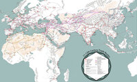 |
Map: 11th - 12th Century Trade Routes | | 11th - 12th Century CE |