Home
Browse
Ask Us
Chat
Harmful Language Statement
Log in
Advanced Search
Year
1900
1901
1902
1903
1904
1905
1906
1907
1908
1909
1910
1911
1912
1913
1914
1915
1916
1917
1918
1919
1920
1921
1922
1923
1924
1925
1926
1927
1928
1929
1930
1931
1932
1933
1934
1935
1936
1937
1938
1939
1940
1941
1942
1943
1944
1945
1946
1947
1948
1949
1950
1951
1952
1953
1954
1955
1956
1957
1958
1959
1960
1961
1962
1963
1964
1965
1966
1967
1968
1969
1970
1971
1972
1973
1974
1975
1976
1977
1978
1979
1980
1981
1982
1983
1984
1985
1986
1987
1988
TO
1900
1901
1902
1903
1904
1905
1906
1907
1908
1909
1910
1911
1912
1913
1914
1915
1916
1917
1918
1919
1920
1921
1922
1923
1924
1925
1926
1927
1928
1929
1930
1931
1932
1933
1934
1935
1936
1937
1938
1939
1940
1941
1942
1943
1944
1945
1946
1947
1948
1949
1950
1951
1952
1953
1954
1955
1956
1957
1958
1959
1960
1961
1962
1963
1964
1965
1966
1967
1968
1969
1970
1971
1972
1973
1974
1975
1976
1977
1978
1979
1980
1981
1982
1983
1984
1985
1986
1987
1988
Type
Image
73
Text
16
Format
image/jpeg
29
application/pdf
17
application/vnd.google-earth.kmz
14
application/zip
13
Collection
Beckwith Photograph Collection
16
Classified Photographs
10
Park City Historical Society & Museum
1
Regional History Center
2
Theses & Dissertations
44
Filters:
Subject:
"Geology"
Type:
"Image"
51
-
75
of
73
<
1
2
3
>
Gallery view
Number of results to display per page
10
25
50
100
200
Sort by Relevance
Sort by Title A-Z
Sort by Title Z-A
Sort by Date Ascending
Sort by Date Descending
Sort by Last Modified Ascending
Sort by Last Modified Descending
Title
Date
Type
Setname
51
John F. Steward
Image
dha_cp
52
Map 1 Geologic map of the Soldier Summit Quadrangle, Utah (Google Earth map overlay KMZ file)
1965-06
Image
ir_etd
53
Map1 Geologic map and sections of Newfoundland Mountains, Box Elder County, Utah (Google Earth map overlay KMZ file)
1956-12
Image
ir_etd
54
Map1 Geologic map and sections of Smith and Morehouse-Hayden Fork area, Utah (Google Earth map overlay KMZ file)
1952
Image
ir_etd
55
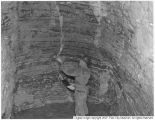
Mayflower Mine, Walter Bauer inspecting bedded limestone
1950
Image
pc_hsm
56
Mount Ogden granite (Thesis and maps)
1969-06
Text; Image
ir_etd
57
Mount Ogden granite: Georeferenced map files
1969-06
Image
ir_etd
58
Plate 1 Fence diagram Moenkopi group (Google Earth map overlay KMZ file)
1969-06
Image
ir_etd
59
Plate 1 Geologic map of Stansbury Island, Tooele County, Utah (Google Earth map overlay KMZ file)
1969-06
Image
ir_etd
60
Plate 1: Geologic map of the Lothidok Range, Kenya
1988-08
Image
ir_etd
61
Plates 2-3 Geologic map of the Mount Ogden granite, Weber County, Utah and Geologic sections to accompany the Geologic map of the Mount Ogden granite, Weber County, Utah (Google Earth map overlay KMZ file)
1969-06
Image
ir_etd
62
Reminiscences of Frank A. Beckwith, by Charles Kelly [2]
Image
dc_bpc
63
Stratigraphic analysis of the Mesaverde Group, Uinta Basin, Utah
1961-05
Text; Image
ir_etd
64
Stratigraphic analysis of the Mesaverde Group, Uinta Basin, Utah (Google Earth map overlay KMZ file)
1961-05
Image
ir_etd
65
Stratigraphic analysis of the Mesaverde Group, Uinta Basin, Utah: Georeferenced map files
1961-05
Image
ir_etd
66
Subsurface geology of the Mesozoic formations overlying the Uncompahgre Uplift in Grand County, Utah
1961-06
Text; Image
ir_etd
67
Subsurface geology of the Mesozoic formations overlying the Uncompahgre Uplift in Grand County, Utah (Google Earth map overlay KMZ file)
1961-06
Image
ir_etd
68
Subsurface geology of the Mesozoic formations overlying the Uncompahgre Uplift in Grand County, Utah: Georeferenced map files
1961-06
Image
ir_etd
69
Tertiary Salt Lake group in the Great Salt Lake Basin
1955-07
Text; Image
ir_etd
70
Tertiary Salt Lake group in the Great Salt Lake Basin (Google Earth map overlay KMZ file)
1955-07
Image
ir_etd
71
Tertiary Salt Lake group in the Great Salt Lake Basin: Georeferenced map files
1955-07
Image
ir_etd
72
The Thaynes formation of the Moenkopi group, North-Central Utah (Thesis and maps)
1969-06
Text; Image
ir_etd
73
The Thaynes formation of the Moenkopi group, North-Central Utah: Georeferenced map files
1969-06
Image
ir_etd
51
-
75
of
73
<
1
2
3
>