Home
Browse
Ask Us
Chat
Harmful Language Statement
Log in
Advanced Search
Year
1860
1861
1862
1863
1864
1865
1866
1867
1868
1869
1870
1871
1872
1873
1874
1875
1876
1877
1878
1879
1880
1881
1882
1883
1884
1885
1886
1887
1888
1889
1890
1891
1892
1893
1894
1895
1896
1897
1898
1899
1900
1901
1902
1903
1904
1905
1906
1907
1908
1909
1910
1911
1912
1913
1914
1915
1916
1917
1918
1919
1920
1921
1922
1923
1924
1925
1926
1927
1928
1929
1930
1931
1932
1933
1934
1935
1936
1937
1938
1939
1940
1941
1942
1943
1944
1945
1946
1947
1948
1949
1950
1951
1952
1953
1954
1955
1956
1957
1958
1959
1960
1961
1962
1963
1964
1965
1966
1967
1968
1969
1970
1971
1972
1973
1974
1975
1976
1977
1978
1979
1980
1981
1982
1983
1984
1985
1986
1987
1988
1989
1990
1991
1992
1993
1994
1995
1996
1997
1998
1999
2000
2001
2002
2003
2004
2005
TO
1860
1861
1862
1863
1864
1865
1866
1867
1868
1869
1870
1871
1872
1873
1874
1875
1876
1877
1878
1879
1880
1881
1882
1883
1884
1885
1886
1887
1888
1889
1890
1891
1892
1893
1894
1895
1896
1897
1898
1899
1900
1901
1902
1903
1904
1905
1906
1907
1908
1909
1910
1911
1912
1913
1914
1915
1916
1917
1918
1919
1920
1921
1922
1923
1924
1925
1926
1927
1928
1929
1930
1931
1932
1933
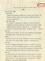
1934
1935
1936
1937
1938
1939
1940
1941
1942
1943
1944
1945
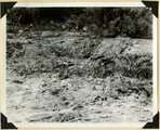
1946
1947
1948
1949
1950
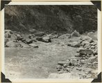
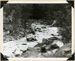
1951
1952
1953
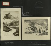
1954
1955
1956
1957
1958
1959
1960
1961
1962
1963
1964
1965
1966
1967
1968
1969
1970
1971
1972
1973
1974
1975
1976
1977
1978
1979
1980
1981
1982
1983
1984
1985
1986
1987
1988
1989
1990
1991
1992
1993
1994
1995
1996
1997
1998
1999
2000
2001
2002
2003
2004
2005
Type
Image
297
Image/StillImage
204
Text
2
Image/MovingImage
1
Sound
1
Format
image/jpeg
533
application/pdf
14
video/mp4
2
Collection
Beckwith Photograph Collection
5
O.L. Tapp Film Collection
1
Photo Archives
333
Ski and Snow Sports Archives
13
UAIDA Main Collection
1
Utah Artists Project
1
Utah Humanities Research Foundation
2
Utah River Running Photo Archives
192
Western Soundscape
1
More
Filters:
Spatial Coverage:
"Zion National Park (Utah)"
Year End:
2016
226
-
250
of
549
<
5
6
7
8
9
10
11
12
13
14
>
Gallery view
Number of results to display per page
10
25
50
100
200
Sort by Relevance
Sort by Title A-Z
Sort by Title Z-A
Sort by Date Ascending
Sort by Date Descending
Sort by Last Modified Ascending
Sort by Last Modified Descending
Title
Date
Type
Setname
226
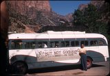
Tour bus for The Utah Centennial Commission presents "But Not Goodbye" with the University of Utah Theatre on tour, Zion National Park, 1947
1947
Image/StillImage
uum_map
227
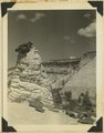
Tower of Navajo sandstone capped by iron concretion along highway near east Checking Station, Zion National Park, Utah, 1936.
1937
Image
uum_map
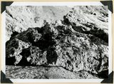
228
Travertine formed by plants, narrows of Virgin River. Zion National Park, UT
1937
Image
uum_map
229
Trip Over Cedar Mountains & Zion Narrows
1905-04-02
Text
uum_uhrf
230
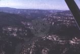
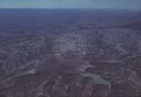
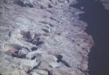
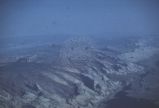
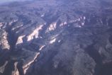
Unidentified desert scenery and geology - aerial view [020]
1950; 1951; 1952; 1953; 1954; 1955; 1956; 1957; 1958; 1959; 1960; 1961; 1962; 1963; 1964; 1965; 1966; 1967; 1968; 1969; 1970; 1971; 1972; 1973; 1974; 1975; 1976; 1977; 1978; 1979; 1980
Image
uum_map_rr
231
Unidentified desert scenery and geology - aerial view [021]
1950; 1951; 1952; 1953; 1954; 1955; 1956; 1957; 1958; 1959; 1960; 1961; 1962; 1963; 1964; 1965; 1966; 1967; 1968; 1969; 1970; 1971; 1972; 1973; 1974; 1975; 1976; 1977; 1978; 1979; 1980
Image
uum_map_rr
232
Unidentified desert scenery and geology - aerial view [022]
1950; 1951; 1952; 1953; 1954; 1955; 1956; 1957; 1958; 1959; 1960; 1961; 1962; 1963; 1964; 1965; 1966; 1967; 1968; 1969; 1970; 1971; 1972; 1973; 1974; 1975; 1976; 1977; 1978; 1979; 1980
Image
uum_map_rr
233
Unidentified desert scenery and geology - aerial view [023]
1950; 1951; 1952; 1953; 1954; 1955; 1956; 1957; 1958; 1959; 1960; 1961; 1962; 1963; 1964; 1965; 1966; 1967; 1968; 1969; 1970; 1971; 1972; 1973; 1974; 1975; 1976; 1977; 1978; 1979; 1980
Image
uum_map_rr
234
Unidentified desert scenery and geology - aerial view [024]
1950; 1951; 1952; 1953; 1954; 1955; 1956; 1957; 1958; 1959; 1960; 1961; 1962; 1963; 1964; 1965; 1966; 1967; 1968; 1969; 1970; 1971; 1972; 1973; 1974; 1975; 1976; 1977; 1978; 1979; 1980
Image
uum_map_rr
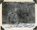
235
Upper Chinle, Wingate, Kayenta, and Navajo formations on face of Bridge Mountain. Springdale member, ledge near base. Zion National Park, UT
1937
Image
uum_map
236
Utah artist Fairbanks at work in Zion National Park
1920; 1921; 1922; 1923
uum_map
237
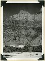
View from Great Arch Trail, Zion
1959-06-25
Image
uum_map
238
View in Zion Canyon, UT. LaPlata strata overlying Chinle. Kane County, UT. 1922
1922
Image
uum_map
239
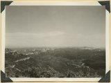
View looking down Virgin River from Hornet Point, towers of Zion National Park in distance. Washington County, UT, 1940
1940
Image
uum_map
240
View looking north from Pace Knoll (lava) near Deadman Gulch, showing tilted strata east of Hurricane Cliffs (extreme left). Virgin member of Moenkopi, Shinarump conglomerate and Chinle sandstones make hogbacks. Horse Ranch knoll, Navajo and Carmel in upper right, Washington County, UT, 1941
1941
Image
uum_map
241
Virgin River in Zion National Park: erosion of land slide at flood stage
1937; 1938
Image
uum_map
242
Virgin River in Zion National Park: flood stage
1937; 1938
Image
uum_map
243
Virgin River in Zion National Park: flood stage
1937; 1938
Image
uum_map
244
Virgin River in Zion National Park: rising flood from shower on Kolob Terrace
1937; 1938
Image
uum_map
245
Virgin River in Zion National Park: rising flood from shower on Kolob Terrace
1937; 1938
Image
uum_map
246
Virgin River Zion Park.
1861; 1862; 1863; 1864; 1865; 1866; 1867; 1868; 1869; 1870
Image
uum_map
247
Virgin River, Zion Park.
1861; 1862; 1863; 1864; 1865; 1866; 1867; 1868; 1869; 1870
Image
uum_map
248
Walters Wiggles, in Refrigerator Canyon, on trail to Angels Landing. Navajo strata. Zion National Park, Utah, 1936.
1936
Image
uum_map
249
Wasatch Mountain Club photo album, Book 2
1920; 1921; 1922; 1923
uum_map
250
Wasatch Mountain Club swimming in the Virgin River
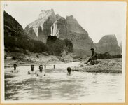
1920; 1921; 1922; 1923
uum_map
226
-
250
of
549
<
5
6
7
8
9
10
11
12
13
14
>