|
|
Title | Date | Type | Setname |
| 1 |
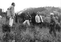 | Alex Morley, Paul McCollister, and Willie Schaeffler on the far right, scoping out the mountain about half way up of what is now known as the "Slalom" ski run at Jackson Hole, circa 1961 | 1959; 1960; 1961; 1962; 1963 | Image/StillImage | uum_map_usa |
| 2 |
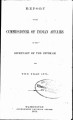 | Annual Report of the Commissioner of Indian Affairs - 1871 | 1871 | Image/StillImage | uaida_main |
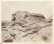
| 3 |
 | Anticline - Five miles east of Cody, Wyo. | 1914-06 | Image/StillImage | uum_map |
| 4 |
 | Anticline - Five miles east of Cody, Wyo. | 1914-06 | Image/StillImage | uum_map |
| 5 |
 | Anticline - Five miles east of Cody, Wyo. | 1914-06 | Image/StillImage | uum_map |
| 6 |
 | Anticline - Sheep Mountain - Wyo | 1914-06 | Image/StillImage | uum_map |
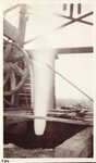
| 7 |
 | Anticline - Sheep Mountain - Wyo | 1914-06 | Image/StillImage | uum_map |
| 8 |
 | Anticline - Sheep Mountain - Wyo | 1914-06 | Image/StillImage | uum_map |
| 9 |
 | Ashley National Forest - Forest Visitor Map 1998 | 1998 | Image/StillImage | ucl_maps |
| 10 |
 | Ashley National Forest - Utah, Wyoming - Uintah, Salt Lake and Sixth Principal Meridians 1971 | 1971 | Image/StillImage | ucl_maps |
| 11 |
 | Ashley National Forest Travel Map - Flaming Gorge, Vernal, Roosevelt, and Duchesne Ranger Districts 1971 | 1971 | Image/StillImage | ucl_maps |
| 12 |
 | Ashley National Forest Utah and Wyoming - Roosevelt, Flaming Gorge, and Vernal Ranger Districts 1971 | 1971 | Image/StillImage | ucl_maps |
| 13 |
 | Band in front of Lyman High school, Wyoming, circa 1920s | 1918; 1919; 1920; 1921; 1922; 1923; 1924; 1925; 1926; 1927; 1928; 1929; 1930; 1931 | Image/StillImage | uum_map |
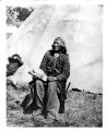
| 14 |
 | Bannock Indians | 1871; 1872; 1873; 1874; 1875; 1876; 1877; 1878 | Image/StillImage | uaida_main |
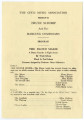
| 15 |
 | Bannock Indians [WHJ-10098] | 1871; 1872; 1873; 1874; 1875; 1876; 1877; 1878 | Image/StillImage | uaida_main |
| 16 |
 | Bison, Grand Teton, 1991 | 1991-08 | Image/StillImage | uum_map |
| 17 |
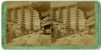
 | Black's Fork of the Green River p.1 | 1933; 1934; 1935; 1936; 1937; 1938; 1939; 1940; 1941; 1942; 1943; 1944; 1945; 1946 | Image/StillImage | dha_cp |
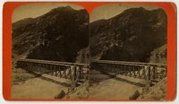
| 18 |
 | Boundary of Shoshone Indian Territory according to Swanton, 1952 | 1952 | Image/StillImage | uaida_main |
| 19 |
 | Boundary of Shoshone Indian Territory, Linguistic Boundaries of Shoshone and Bannock. | 1941 | Image/StillImage | uaida_main |
| 20 |
 | Boundary of Shoshone Indian Territory, showing the locations of the Bannock | 1957 | Image/StillImage | uaida_main |
| 21 |
 | Boundary of Shoshone Indian Territory, showing the locations of the Bannock from 1819 to 1951 | 1957 | Image/StillImage | uaida_main |
| 22 |
 | Boundary of Shoshone Indian Territory, showing the locations where the Bannock and Shoshone reported together 1819-1956 | 1957 | Image/StillImage | uaida_main |
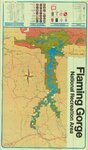
| 23 |
 | Boundary of Shoshone Indian Territory; Doty Map of 1863 Indian Claims Commission | 1957 | Image/StillImage | uaida_main |
| 24 |
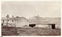
 | Bridger, Wyoming, Cobble rock wall erected by Mormons | 1920; 1921; 1922; 1923; 1924; 1925; 1926; 1927; 1928; 1929; 1930; 1931; 1932; 1933; 1934; 1935 | Image/StillImage | uum_map |
| 25 |
 | Buck elk, 1991 | 1991-08 | Image/StillImage | uum_map |
| 26 |
 | Camp Bishop Head Wind River | 1883 | Image/StillImage | uaida_main |
| 27 |
 | Cemetery, Lander, Wyoming | 1958; 1959; 1960; 1961; 1962 | Image/StillImage | uum_map |
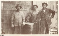
| 28 |
 | Charley and Norma Burton at Snowy Cabin | 1947; 1948; 1949; 1950 | Image/StillImage | ucl_rhc |
| 29 |
 | Chief Washakie | 1888; 1889; 1890; 1891; 1892 | Image/StillImage | uaida_main |
| 30 |
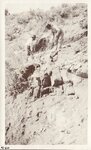
 | Chief Washakie seated in front of a tepee | 1885 | Image/StillImage | uaida_main |
| 31 |
 | Civic Music Association Programs | 1927; 1928; 1929; 1930; 1931; 1932; 1933; 1934; 1935; 1936; 1937; 1938; 1939; 1940; 1941 | Text; Image/StillImage | dha_tpc |
| 32 |
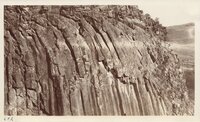 | Columnar Structure - Little Snake River - SW Wyoming | 1907; 1908; 1909; 1910; 1911; 1912; 1913; 1914; 1915; 1916; 1917; 1918; 1919; 1920; 1921; 1922; 1923; 1924; 1925; 1926; 1927; 1928; 1929; 1930; 1931; 1932; 1933; 1934; 1935 | Image/StillImage | uum_map |
| 33 |
 | Columnar Structure - Little Snake River - SW Wyoming | 1907; 1908; 1909; 1910; 1911; 1912; 1913; 1914; 1915; 1916; 1917; 1918; 1919; 1920; 1921; 1922; 1923; 1924; 1925; 1926; 1927; 1928; 1929; 1930; 1931; 1932; 1933; 1934; 1935 | Image/StillImage | uum_map |
| 34 |
 | Columnar Structure - Little Snake River - SW Wyoming | 1907; 1908; 1909; 1910; 1911; 1912; 1913; 1914; 1915; 1916; 1917; 1918; 1919; 1920; 1921; 1922; 1923; 1924; 1925; 1926; 1927; 1928; 1929; 1930; 1931; 1932; 1933; 1934; 1935 | Image/StillImage | uum_map |
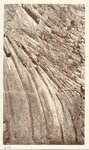
| 35 |
 | Cross bedding, one mile south of Cowley, Wyo. | 1907; 1908; 1909; 1910; 1911; 1912; 1913; 1914; 1915; 1916; 1917; 1918; 1919; 1920; 1921; 1922; 1923; 1924; 1925; 1926; 1927; 1928; 1929; 1930; 1931; 1932; 1933; 1934; 1935 | Image/StillImage | uum_map |
| 36 |
 | Dale Creek bridge, 132 feet high | 1869; 1870; 1871 | Image/StillImage | uum_map |
| 37 |
 | Devil's Gate Bridge | 1870; 1871; 1872; 1873; 1874; 1875; 1876; 1877; 1878; 1879; 1880; 1881; 1882; 1883; 1884; 1885; 1886; 1887; 1888; 1889; 1890 | Image/StillImage | uum_map |
| 38 |
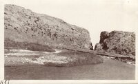 | Devils Gate, Sweetwater River, Wyoming | 1920; 1921; 1922; 1923; 1924; 1925; 1926; 1927; 1928; 1929; 1930; 1931; 1932; 1933; 1934; 1935 | Image/StillImage | uum_map |
| 39 |
 | Dutch John, Utah-Colorado-Wyoming 1981 | 1981 | Image/StillImage | ucl_maps |
| 40 |
 | Dutch John, Utah-Colorado-Wyoming 1982 | 1981; 1982 | Image/StillImage | ucl_maps |
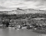
| 41 |
 | Dyke - Eroded - Near Shoshone Dam - Wyo | 1907; 1908; 1909; 1910; 1911; 1912; 1913; 1914; 1915; 1916; 1917; 1918; 1919; 1920; 1921; 1922; 1923; 1924; 1925; 1926; 1927; 1928; 1929; 1930; 1931; 1932; 1933; 1934; 1935 | Image/StillImage | uum_map |
| 42 |
 | Early western travels, 1748-1846 | 1906 | Image/StillImage | uaida_main |
| 43 |
 | Emigrants en route to Oregon, Sweetwater district, Western Wyoming | 1930; 1931; 1932; 1933; 1934; 1935; 1936; 1937; 1938; 1939; 1940; 1941; 1942; 1943; 1944; 1945; 1946; 1947; 1948; 1949; 1950; 1951; 1952; 1953; 1954; 1955; 1956; 1957; 1958; 1959; 1960 | Image/StillImage | uum_map |
| 44 |
 | Faithful Watch | | Image/StillImage | uu_uap |
| 45 |
 | Fault, Byron, Wyoming | 1907; 1908; 1909; 1910; 1911; 1912; 1913; 1914; 1915; 1916; 1917; 1918; 1919; 1920; 1921; 1922; 1923; 1924; 1925; 1926; 1927; 1928; 1929; 1930; 1931; 1932; 1933; 1934; 1935 | Image/StillImage | uum_map |
| 46 |
 | Fault, Byron, Wyoming: Fred Kohler and Walker | 1907; 1908; 1909; 1910; 1911; 1912; 1913; 1914; 1915; 1916; 1917; 1918; 1919; 1920; 1921; 1922; 1923; 1924; 1925; 1926; 1927; 1928; 1929; 1930; 1931; 1932; 1933; 1934; 1935 | Image/StillImage | uum_map |
| 47 |
 | Flaming Gorge Country (Brochure and Map) | 1987 | Image/StillImage | ucl_maps |
| 48 |
 | Flaming Gorge National Recreation Area | 1987 | Image/StillImage | ucl_maps |
| 49 |
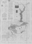
 | Flaming Gorge National Recreation Area - Ashley National Forest | | Image/StillImage | ucl_maps |
| 50 |
 | Flaming Gorge National Recreation Area - Ashley National Forest 1962 | 1962 | Image/StillImage | ucl_maps |
| 51 |
 | Fort Bridger - Wyo - Wall at Middle Right Built by Mormons | 1907; 1908; 1909; 1910; 1911; 1912; 1913; 1914; 1915; 1916; 1917; 1918; 1919; 1920; 1921; 1922; 1923; 1924; 1925; 1926; 1927; 1928; 1929; 1930; 1931; 1932; 1933; 1934; 1935 | Image/StillImage | uum_map |
| 52 |
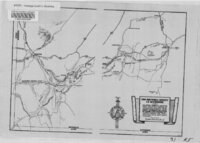
 | Fort Bridger, Original Survey | | Image/StillImage | ucl_maps |
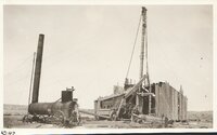
| 53 |
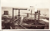 | Gas well, Byron, Wyoming [01] | 1907; 1908; 1909; 1910; 1911; 1912; 1913; 1914; 1915; 1916; 1917; 1918; 1919; 1920; 1921; 1922; 1923; 1924; 1925; 1926; 1927; 1928; 1929; 1930; 1931; 1932; 1933; 1934; 1935 | Image/StillImage | uum_map |
| 54 |
 | Gas well, Byron, Wyoming [02] | 1907; 1908; 1909; 1910; 1911; 1912; 1913; 1914; 1915; 1916; 1917; 1918; 1919; 1920; 1921; 1922; 1923; 1924; 1925; 1926; 1927; 1928; 1929; 1930; 1931; 1932; 1933; 1934; 1935 | Image/StillImage | uum_map |
| 55 |
 | Gas well, Byron, Wyoming [03] | 1907; 1908; 1909; 1910; 1911; 1912; 1913; 1914; 1915; 1916; 1917; 1918; 1919; 1920; 1921; 1922; 1923; 1924; 1925; 1926; 1927; 1928; 1929; 1930; 1931; 1932; 1933; 1934; 1935 | Image/StillImage | uum_map |
| 56 |
 | Gas well, Byron, Wyoming [04] | 1907; 1908; 1909; 1910; 1911; 1912; 1913; 1914; 1915; 1916; 1917; 1918; 1919; 1920; 1921; 1922; 1923; 1924; 1925; 1926; 1927; 1928; 1929; 1930; 1931; 1932; 1933; 1934; 1935 | Image/StillImage | uum_map |
| 57 |
 | Gas well, Byron, Wyoming [05] | 1908; 1909; 1910; 1911; 1912; 1913; 1914; 1915; 1916; 1917; 1918; 1919; 1920; 1921; 1922; 1923; 1924; 1925; 1926; 1927; 1928; 1929; 1930; 1931; 1932; 1933; 1934; 1935 | Image/StillImage | uum_map |
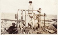
| 58 |
 | Gas well, Byron, Wyoming: Fred Kohler - Roy Willey - Perry Sessions | 1907; 1908; 1909; 1910; 1911; 1912; 1913; 1914; 1915; 1916; 1917; 1918; 1919; 1920; 1921; 1922; 1923; 1924; 1925; 1926; 1927; 1928; 1929; 1930; 1931; 1932; 1933; 1934; 1935 | Image/StillImage | uum_map |
| 59 |
 | Gas well, Byron, Wyoming: Fred Kohler [01] | 1907; 1908; 1909; 1910; 1911; 1912; 1913; 1914; 1915; 1916; 1917; 1918; 1919; 1920; 1921; 1922; 1923; 1924; 1925; 1926; 1927; 1928; 1929; 1930; 1931; 1932; 1933; 1934; 1935 | Image/StillImage | uum_map |
| 60 |
 | Gas well, Byron, Wyoming: Fred Kohler [02] | 1907; 1908; 1909; 1910; 1911; 1912; 1913; 1914; 1915; 1916; 1917; 1918; 1919; 1920; 1921; 1922; 1923; 1924; 1925; 1926; 1927; 1928; 1929; 1930; 1931; 1932; 1933; 1934; 1935 | Image/StillImage | uum_map |
| 61 |
 | Gas well, Byron, Wyoming: Fred Kohler [03] | 1907; 1908; 1909; 1910; 1911; 1912; 1913; 1914; 1915; 1916; 1917; 1918; 1919; 1920; 1921; 1922; 1923; 1924; 1925; 1926; 1927; 1928; 1929; 1930; 1931; 1932; 1933; 1934; 1935 | Image/StillImage | uum_map |
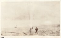
| 62 |
 | Geology Party - Auto Overrturned - East of Rock Springs | 1910; 1911; 1912; 1913; 1914; 1915; 1916; 1917; 1918; 1919; 1920; 1921; 1922; 1923; 1924; 1925; 1926; 1927; 1928; 1929; 1930; 1931; 1932; 1933; 1934; 1935 | Image/StillImage | uum_map |
| 63 |
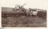 | Geology party, auto overturned east of Rock Springs | 1927; 1928; 1929; 1930; 1931; 1932; 1933 | Image/StillImage | uum_map |
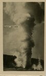
| 64 |
 | Giant Geyser, Yellowstone National Park | 1920; 1921; 1922; 1923; 1924; 1925; 1926; 1927; 1928; 1929 | Image/StillImage | uum_map |
| 65 |
 | Governor's Conference (1937) P.1 | 1937-09-16 | Image/StillImage | dha_cp |
| 66 |
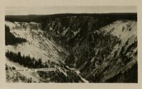 | Grand Canyon of the Yellowstone River, within the national park | 1920; 1921; 1922; 1923; 1924; 1925; 1926; 1927; 1928; 1929 | Image/StillImage | uum_map |
| 67 |
 | Grand Teton p.1 | 1924 | Image/StillImage | dha_cp |
| 68 |
 | Grave of Thornsburg, The stable dog at Fort Bridger, Wyoming, July 28, 1958 | 1958-07-28 | Image/StillImage | uum_map |
| 69 |
 | Great falls of the Yellowstone, from point lookout | 1920; 1921; 1922; 1923; 1924; 1925; 1926; 1927; 1928; 1929 | Image/StillImage | uum_map |
| 70 |
 | Green River - Flaming Gorge National Recreation Area, Ashley National Forest | | Image/StillImage | ucl_maps |
| 71 |
 | Green River p.1 | 1933-07-24 | Image/StillImage | dha_cp |
| 72 |
 | The Hastings Cutoff in Wyoming | | Image/StillImage | ucl_maps |
| 73 |
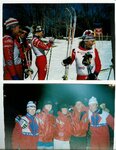 | Heidi Selnes and the University of Utah Ski Team [02] | 1996-03-06; 1996-03-07; 1996-03-08; 1996-03-09 | Image/StillImage | uum_map_usa |
| 74 |
 | Hickman's farm | 1987-08-18 | Image/StillImage | uum_map |
| 75 |
 | Hope A. Hilton | 1987-08-18 | Image/StillImage | uum_map |
| 76 |
 | Horse Creek (Wyo.) p. 1 | 1925; 1926; 1927; 1928; 1929; 1930; 1931; 1932; 1933; 1934; 1935; 1936; 1937; 1938 | Image/StillImage | dha_cp |
| 77 |
 | Howard home at Byron | 1907; 1908; 1909; 1910; 1911; 1912; 1913; 1914; 1915; 1916; 1917; 1918; 1919; 1920; 1921; 1922; 1923; 1924; 1925; 1926; 1927; 1928; 1929; 1930; 1931; 1932; 1933; 1934; 1935 | Image/StillImage | uum_map |
| 78 |
 | Independence Rock, the Sweetwater River and Devil's Gate | 1930; 1931; 1932; 1933; 1934; 1935; 1936; 1937; 1938; 1939; 1940; 1941; 1942; 1943; 1944; 1945; 1946; 1947; 1948; 1949; 1950; 1951; 1952; 1953; 1954; 1955; 1956; 1957; 1958; 1959; 1960 | Image/StillImage | uum_map |
| 79 |
 | Indian at Fort Washakie, Wyo | 1910; 1911; 1912; 1913; 1914; 1915; 1916; 1917; 1918; 1919; 1920; 1921; 1922; 1923; 1924; 1925; 1926; 1927; 1928; 1929; 1930 | Image/StillImage | uaida_main |
| 80 |
 | Indian Sketches from the Journals of T. D. Brown and Jacob Hamblin | 1869 | Image/StillImage | uaida_main |
| 81 |
| Indians in camp - Cheyenne Frontier Days | 1910; 1911; 1912; 1913; 1914; 1915; 1916; 1917; 1918; 1919; 1920; 1921; 1922; 1923; 1924; 1925; 1926; 1927; 1928; 1929; 1930 | Image/StillImage | uaida_main |
| 82 |
 | Inscription Island | 1940; 1941; 1942; 1943; 1944; 1945; 1946; 1947; 1948; 1949; 1950 | Image/StillImage | dha_alwmc |
| 83 |
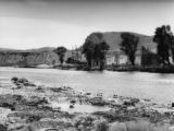
 | Jackson Hole, Wyoming | 1958 | Image/StillImage | uum_map |
| 84 |
| John Enos and Edm. LeClair | 1902; 1903; 1904; 1905; 1906; 1907; 1908; 1909; 1910; 1911; 1912; 1913; 1914; 1915; 1916; 1917; 1918; 1919; 1920 | Image/StillImage | uaida_main |
| 85 |
 | Kings Peak, Utah-Wyoming 1982 | 1982 | Image/StillImage | ucl_maps |
| 86 |
 | Letter from Indian Agent Luther Mann Jr. to Utah Superintendent F.H. Head dated October 8, 1867 | 1867-10-08 | Image/StillImage | uaida_main |
| 87 |
 | Letter from Indian Agent Luther Mann Jr. to Utah Superintendent F.H. Head dated September 26, 1867 | 1867-09-26 | Image/StillImage | uaida_main |
| 88 |
 | Letter from Indian Agent Luther Mann Jr. to Utah Superintendent J.H Head on March 12, 1869 | 1869-03-12 | Image/StillImage | uaida_main |
| 89 |
 | Letter from Indian Agent Luther Mann Jr. to Utah Superintendent J.H. Head dated August 16, 1868 | 1868-08-16 | Image/StillImage | uaida_main |
| 90 |
 | Letter from Indian Agent Luther Mann Jr. to Utah Superintendent J.H. Head dated January 26, 1869 | 1869-01-26 | Image/StillImage | uaida_main |
| 91 |
 | Letter from Indian Agent Luther Mann Jr. to Utah Superintendent J.H. Head dated July 13, 1868 | 1868-07-13 | Image/StillImage | uaida_main |
| 92 |
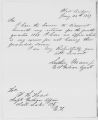
 | Letter from Indian Agent Luther Mann Jr. to Utah Superintendent J.H. Head on May 12, 1868 | 1868-04-20 | Image/StillImage | uaida_main |
| 93 |
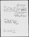
 | Letter from Indian Agent Luther Mann to Utah Superintendent J.H. Head dated April 2, 1869 | 1869-04-02 | Image/StillImage | uaida_main |
| 94 |
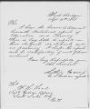
 | Letter from Indian Agent Luther Mann to Utah Superintendent J.H. Head dated January 20, 1869 | 1869-01-20 | Image/StillImage | uaida_main |
| 95 |
 | Letter from Indian Agent to Utah Superintendency on September 12, 1868 | 1868-09-12 | Image/StillImage | uaida_main |
| 96 |
 | Letter from Indian Agent to Utah Superintendency on September 14, 1868 | 1868-09-14 | Image/StillImage | uaida_main |
| 97 |
 | Letter from Lieutenant Graffam to J.E. Tourtellotte dated November 15, 1870 | 1870-11-15 | Image/StillImage | uaida_main |
| 98 |
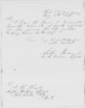 | Letter from Luther Mann on May 16, 1867 | 1867-05-16 | Image/StillImage | uaida_main |
| 99 |
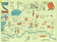
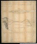
 | Letter to Col. F.H. Head from A. Carter dated January 11, 1868 | 1868-01-11 | Image/StillImage | uaida_main |
| 100 |
 | Map of an exploring expedition to the Rocky Mountains in the year 1842 and to Oregon & North California in the years 1843-44 | 1845 | Image/StillImage | uu_awm |