Home
Browse
Ask Us
Chat
Harmful Language Statement
Log in
Advanced Search
Year
1768
1769
1770
1771
1772
1773
1774
1775
1776
1777
1778
1779
1780
1781
1782
1783
1784
1785
1786
1787
1788
1789
1790
1791
1792
1793
1794
1795
1796
1797
1798
1799
1800
1801
1802
1803
1804
1805
1806
1807
1808
1809
1810
1811
1812
1813
1814
1815
1816
1817
1818
1819
1820
1821
1822
1823
1824
1825
1826
1827
1828
1829
1830
1831
1832
1833
1834
1835
1836
1837
1838
1839
1840
1841
1842
1843
1844
1845
1846
1847
1848
1849
1850
1851
1852
1853
1854
1855
1856
1857
1858
1859
1860
1861
1862
1863
1864
1865
1866
1867
1868
1869
1870
1871
1872
1873
1874
1875
1876
1877
1878
1879
1880
1881
1882
1883
1884
1885
1886
1887
1888
1889
1890
1891
1892
1893
1894
1895
1896
1897
1898
1899
1900
1901
1902
1903
1904
1905
1906
1907
1908
1909
1910
1911
1912
1913
1914
1915
1916
1917
1918
1919
1920
1921
1922
1923
1924
1925
1926
1927
1928
1929
1930
1931
1932
1933
1934
1935
1936
1937
1938
1939
1940
1941
1942
1943
1944
1945
1946
1947
1948
1949
1950
1951
1952
1953
1954
1955
1956
1957
1958
1959
1960
1961
1962
1963
1964
1965
1966
1967
1968
1969
1970
1971
1972
1973
1974
1975
1976
1977
1978
1979
1980
1981
1982
1983
1984
1985
1986
1987
1988
1989
1990
1991
1992
1993
1994
1995
1996
1997
1998
1999
2000
2001
2002
2003
2004
2005
2006
2007
2008
2009
2010
2011
2012
2013
2014
2015
2016
2017
2018
2019
2020
2021
2022
TO
1768
1769
1770
1771
1772
1773
1774
1775
1776
1777
1778
1779
1780
1781
1782
1783
1784
1785
1786
1787
1788
1789
1790
1791
1792
1793
1794
1795
1796
1797
1798
1799
1800
1801
1802
1803
1804
1805
1806
1807
1808
1809
1810
1811
1812
1813
1814
1815
1816
1817
1818
1819
1820
1821
1822
1823
1824
1825
1826
1827
1828
1829
1830
1831
1832
1833
1834
1835
1836
1837
1838
1839
1840
1841
1842
1843
1844
1845
1846
1847
1848
1849
1850
1851
1852
1853
1854
1855
1856
1857
1858
1859
1860
1861
1862
1863
1864
1865
1866
1867
1868
1869
1870
1871
1872
1873
1874
1875
1876
1877
1878
1879
1880
1881
1882
1883
1884
1885
1886
1887
1888
1889
1890
1891
1892
1893
1894
1895
1896
1897
1898
1899
1900
1901
1902
1903
1904
1905
1906
1907
1908
1909
1910
1911
1912
1913
1914
1915
1916
1917
1918
1919
1920
1921
1922
1923
1924
1925
1926
1927
1928
1929
1930
1931
1932
1933
1934
1935
1936
1937
1938
1939
1940
1941
1942
1943
1944
1945
1946
1947
1948
1949
1950
1951
1952
1953
1954
1955
1956
1957
1958
1959
1960
1961
1962
1963
1964
1965
1966
1967
1968
1969
1970
1971
1972
1973
1974
1975
1976
1977
1978
1979
1980
1981
1982
1983
1984
1985
1986
1987
1988
1989
1990
1991
1992
1993
1994
1995
1996
1997
1998
1999
2000
2001
2002
2003
2004
2005
2006
2007
2008
2009
2010
2011
2012
2013
2014
2015
2016
2017
2018
2019
2020
2021
2022
Type
Image
28,695
Image/StillImage
3,721
Text
2,375
Sound
618
Image/MovingImage
182
Format
image/jpeg
32,506
application/pdf
2,758
video/mp4
604
audio/mpeg
205
application/zip
3
application/xml
1
More
Institution
Department of Cultural and Community ...
25,742
University of Utah Marriott Library
6,134
Utah American Indian Digital Archive
3,145
University of Utah Partnerships
943
Delta City Library
169
Uintah County Library
37
Murray City
33
Western Waters Digital Library
20
Utah State Archives
13
Institutional Repository
10
Westminster University
1
More
Collection
Al W. Morton Collection, 1930s-1950s
431
Alan K Engen Papers
3
Alta Avalanche
2
American West Center Research Projects
1
American Westward Migration
19
Angus Munn Woodbury Papers
24
Artifact Collection
3
Audio-Visual Archives Collections
15
Beckwith Photograph Collection
169
Chicana/o Scholarship Archive
10
City Engineers
1,000
Classified Photographs
13,121
Clifton Bray Film Negatives
1
College of Law Publications
2
Colorado Riverbed Case
13
Cycling Utah
135
Denver & Rio Grande Payroll Ledgers
35
Department of Modern Dance and Ballet
21
Ellis Reynolds Shipp Papers
1
Everett L. Cooley Oral History Project
78
George M. Ottinger Photograph Collection
2
Glen Canyon
1
Hiram B. Clawson Papers
1
Home Movie Collection - Reading Room ...
1
Hotel Utah
6
Humanities In Focus
13
John Hamilton Morgan Papers
35
John Mills Whitaker Papers
8
KUTV EXTRA
2
Kent Day Family Collection
22
Land Use - Transportation Scenario Pl...
1
Manuscripts
7
Murray Museum
33
O.L. Tapp Film Collection
1
Peoples of Utah
1
Philosophical Issues In Human Affairs...
19
Photo Archives
2,272
Regional History Center
28
Schools of the Salt Lake Valley
1
Shipler Commercial Photographers
10,121
Ski and Snow Sports Photo Archives
1,546
Tanner Trust Books
1
Taylor A. Woolley Papers
91
Theater Programs Collection, 1866-1995
63
Thorne Photographs
5
UAIDA Main Collection
3,145
Uintah County Regional History Center...
3
Utah Architects Project
124
Utah Architects and Builders
59
Utah Artists Project
74
Utah Humanities Research Foundation
197
Utah National Register Nomination Forms
19
Utah Quilt Heritage Records
9
Utah River Running Photo Archives
1,659
Utah State Legislators Photographs, 1...
814
Utah's Urban Pioneer Folk Music Reviv...
1
Vernal Express Photographs
1
We Remember, We Celebrate, We Believe...
47
Western Soundscape
708
Western Waters Audio-Video
12
Western Waters Documents
3
Western Waters Electronic Resources
4
Western Waters NEH
1
Westminster University Finding Aids (...
1
Works Progress Administration Biograp...
1
More
Filters:
Spatial Coverage:
"Utah"
1401
-
1425
of
36,247
<
52
53
54
55
56
57
58
59
60
61
>
Gallery view
Number of results to display per page
10
25
50
100
200
Sort by Relevance
Sort by Title A-Z
Sort by Title Z-A
Sort by Date Ascending
Sort by Date Descending
Sort by Last Modified Ascending
Sort by Last Modified Descending
Title
Date
Type
Setname
1401
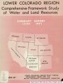
Lower Colorado Region comprehensive framework study of water and land resources : summary report, June 1971
1971-06
Text
wwdl_documents
1402
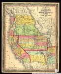
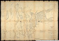
New map of the state of California, the territories of Oregon, Washington, Utah & New Mexico.
1853
Image/StillImage
uu_awm
1403
Space games
1978
Image/MovingImage
uum_dwdb
1404
Tapuche, Utah
1871; 1872; 1873; 1874; 1875
Image/StillImage
uaida_main
1405
Tits and feathers: the Las Vegas alternative
1979
Image/MovingImage
uum_dwdb
1406
Highway 40
Image
ucl_tp
1407
Steamboat Rock On The Yampa River.
Image
ucl_rhc
1408
'Til the cows come home
1979
Image/MovingImage
uum_dwdb
1409
Crossing lines
1978
Image/MovingImage
uum_dwdb
1410
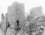
Double tower and mesa buildings in Ruin Canon, Utah
1900
Image/StillImage
uaida_main
1411
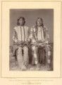
Kwa-ko-nut and Mose, Utah
1868; 1869; 1870; 1871; 1872; 1873; 1874
Image/StillImage
uaida_main
1412
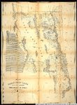
Map no. 2, from the Great Salt Lake to the Humboldt Mountains.
1855
Image/StillImage
uu_awm
1413
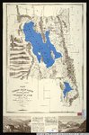
Map of the Great Salt Lake and adjacent country in the territory of Utah.
1850
Image/StillImage
uu_awm
1414
Map of the Great Salt Lake and adjacent country in the territory of Utah.
1852
Image/StillImage
uu_awm
1415
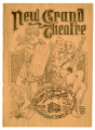
The New Grand Theatre Programs
1900; 1901; 1902
Text; Image/StillImage
dha_tpc
1416
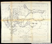
Preliminary Map of Routes Reconnoitered and Opened in the Territory of Utah
1858
Image/StillImage
uu_awm
1417
Sketch of the country between South Pass and the Great Salt Lake.
1857
Image/StillImage
uu_awm
1418
Square Tower, Ruin Canon, Utah
1900
Image/StillImage
uaida_main
1419
Cove Creek Ranch Fork
Image
ucl_tp
1420
Four Men On a Fence
Image
ucl_rhc
1421
Frank Swain, A River Runner
Image
ucl_rhc
1422
Goodfellow, Irving
2008
Text
uum_uap
1423
Hansen, Julius
2008
Text
uum_uap
1424
McFee, Samuel
2008
Text
uum_uap
1425
Military men
Image
dc_bpc
1401
-
1425
of
36,247
<
52
53
54
55
56
57
58
59
60
61
>