Home
Browse
Ask Us
Chat
Harmful Language Statement
Log in
Advanced Search
Year
1849
1850
1851
1852
1853
1854
1855
1856
1857
1858
1859
1860
1861
1862
1863
1864
1865
1866
1867
1868
1869
1870
1871
1872
1873
1874
1875
1876
1877
1878
1879
1880
1881
1882
1883
1884
1885
1886
1887
1888
1889
1890
1891
1892
1893
1894
1895
1896
1897
1898
1899
1900
1901
1902
1903
1904
1905
1906
1907
1908
1909
1910
1911
1912
1913
1914
1915
1916
1917
1918
1919
1920
1921
1922
1923
1924
1925
1926
1927
1928
1929
1930
1931
1932
1933
1934
1935
1936
1937
1938
1939
1940
1941
1942
1943
1944
1945
1946
1947
1948
1949
1950
1951
1952
1953
1954
1955
1956
1957
1958
1959
1960
1961
1962
1963
1964
1965
1966
1967
1968
1969
1970
1971
1972
1973
1974
1975
1976
1977
1978
1979
1980
1981
1982
1983
1984
1985
1986
1987
1988
1989
1990
1991
1992
1993
1994
1995
1996
1997
1998
1999
2000
2001
2002
2003
2004
2005
2006
2007
2008
2009
TO
1849
1850
1851
1852
1853
1854
1855
1856
1857
1858
1859
1860
1861
1862
1863
1864
1865
1866
1867
1868
1869
1870
1871
1872
1873
1874
1875
1876
1877
1878
1879
1880
1881
1882
1883
1884
1885
1886
1887
1888
1889
1890
1891
1892
1893
1894
1895
1896
1897
1898
1899
1900
1901
1902
1903
1904
1905
1906
1907
1908
1909
1910
1911
1912
1913
1914
1915
1916
1917
1918
1919
1920
1921
1922
1923
1924
1925
1926
1927
1928
1929
1930
1931
1932
1933
1934
1935
1936
1937
1938
1939
1940
1941
1942
1943
1944
1945
1946
1947
1948
1949
1950
1951
1952
1953
1954
1955
1956
1957
1958
1959
1960
1961
1962
1963
1964
1965
1966
1967
1968
1969
1970
1971
1972
1973
1974
1975
1976
1977
1978
1979
1980
1981
1982
1983
1984
1985
1986
1987
1988
1989
1990
1991
1992
1993
1994
1995
1996
1997
1998
1999
2000
2001
2002
2003
2004
2005
2006
2007
2008
2009
Type
Image/StillImage
86
Text
62
Image
37
Format
image/jpeg
97
application/pdf
83
application/zip
3
Collection
Classified Photographs
42
Shipler Commercial Photographers
3
Ski and Snow Sports Photo Archives
1
UAIDA Main Collection
139
Filters:
Spatial Coverage:
"Utah"
Subject:
"Maps"
126
-
150
of
185
<
1
2
3
4
5
6
7
8
>
Gallery view
Number of results to display per page
10
25
50
100
200
Sort by Relevance
Sort by Title A-Z
Sort by Title Z-A
Sort by Date Ascending
Sort by Date Descending
Sort by Last Modified Ascending
Sort by Last Modified Descending
Title
Date
Type
Setname
126
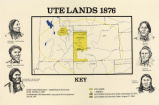
Map titled "Ute Lands, 1876"
Image/StillImage
uaida_main
127
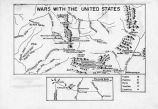
Map titled Wars with the United States
Image/StillImage
uaida_main
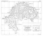
128
Map titled, "Northern Ute Lands, 1905"
Image/StillImage
uaida_main
129
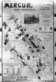
Mercur, Utah P.1
Image
dha_cp
130
Military Installations, Utah P.1
Image
dha_cp
131
Mining Map of Big & Little Cottonwood P.1
Image
dha_cp
132
Naval Supply Depot, Clearfield P.20
1950; 1951; 1952; 1953; 1954; 1955; 1956; 1957; 1958; 1959; 1960; 1961; 1962; 1963
Image/StillImage
dha_cp
133
Naval Supply Depot, Clearfield P.21
1962
Image/StillImage
dha_cp
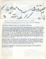
134
Notes from St. Christopher's Mission, 1940's
1940; 1941; 1942; 1942; 1943; 1944; 1945; 1946; 1947; 1948; 1949
Text
uaida_main
135
Notes on the History of the Southern Paiutes and Western Shoshonis
1971
Text
uaida_main
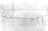
136
Old Map
1952-03-10
Image
dha_scp
137
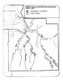
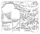
Opening of the Uncompahgre Reservation
Image/StillImage
uaida_main
138
Pahute Indian Home Lands in 1850
1850
Image/StillImage
uaida_main
139
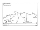
The Paiute Strip
Image/StillImage
uaida_main
140
Problems of Navajo Male Graduates of Intermountain School During Their First Year of Employment
1959
Text
uaida_main
141
Proposed Southern Ute Reservation Reservation 1879, 1889
Image/StillImage
uaida_main
142
Removal of the Colorado Utes to Utah
Image/StillImage
uaida_main
143
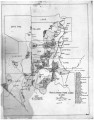
Report of a reconnaissance in the Ute country made in the year 1873, by Lieut. E. H. Ruffner, corps of engineers
1873
Image/StillImage
uaida_main
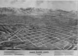
144
Salt Lake City Panoramic View-Illus. P.10
1875
Image/StillImage
dha_cp
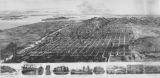
145
Salt Lake City Panoramic View-Illus. P.14
1891
Image/StillImage
dha_cp
146
Salt Lake City Panoramic View-Illus. P.16
1878
Image/StillImage
dha_cp
147
Salt Lake City, City and County Building P.55
1916-08-02
Image/StillImage
dha_cp
148
Shoshone Bannock/ Northwestern Soshone Reservations Geothermal Resource Map
2004-01-14
Image/StillImage
uaida_main
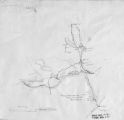
149
Sketch of Uintah Ouray Agencies.
Image/StillImage
uaida_main
150
Southern Paiute Bands
Image/StillImage
uaida_main
126
-
150
of
185
<
1
2
3
4
5
6
7
8
>