Home
Browse
Ask Us
Chat
Harmful Language Statement
Log in
Advanced Search
Year
1849
1850
1851
1852
1853
1854
1855
1856
1857
1858
1859
1860
1861
1862
1863
1864
1865
1866
1867
1868
1869
1870
1871
1872
1873
1874
1875
1876
1877
1878
1879
1880
1881
1882
1883
1884
1885
1886
1887
1888
1889
1890
1891
1892
1893
1894
1895
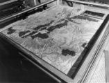
1896
1897
1898
1899
1900
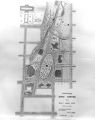
1901
1902
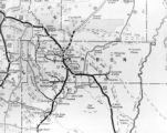
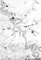
1903
1904
1905
1906
1907
1908
1909
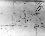
1910
1911
1912
1913
1914
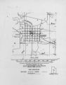
1915
1916
1917
1918
1919
1920
1921
1922
1923
1924
1925
1926
1927
1928
1929
1930
1931
1932
1933
1934
1935
1936
1937
1938
1939
1940
1941
1942
1943
1944
1945
1946
1947
1948
1949
1950
1951
1952
1953
1954
1955
1956
1957
1958
1959
1960
1961
1962
1963
1964
1965
1966
1967
1968
1969
1970
1971
1972
1973
1974
1975
1976
1977
1978
1979
1980
1981
1982
1983
1984
1985
1986
1987
1988
1989
1990
1991
1992
1993
1994
1995
1996
1997
1998
1999
2000
2001
2002
2003
2004
2005
2006
2007
2008
2009
TO
1849
1850
1851
1852
1853
1854
1855
1856
1857
1858
1859
1860
1861
1862
1863
1864
1865
1866
1867
1868
1869
1870
1871
1872
1873
1874
1875
1876
1877
1878
1879
1880
1881
1882
1883
1884
1885
1886
1887
1888
1889
1890
1891
1892
1893
1894
1895
1896
1897
1898
1899
1900
1901
1902
1903
1904
1905
1906
1907
1908
1909
1910
1911
1912
1913
1914
1915
1916
1917
1918
1919
1920
1921
1922
1923
1924
1925
1926
1927
1928
1929
1930
1931
1932
1933
1934
1935
1936
1937
1938
1939
1940
1941
1942
1943
1944
1945
1946
1947
1948
1949
1950
1951
1952
1953
1954
1955
1956
1957
1958
1959
1960
1961
1962
1963
1964
1965
1966
1967
1968
1969
1970
1971
1972
1973
1974
1975
1976
1977
1978
1979
1980
1981
1982
1983
1984
1985
1986
1987
1988
1989
1990
1991
1992
1993
1994
1995
1996
1997
1998
1999
2000
2001
2002
2003
2004
2005
2006
2007
2008
2009
Type
Image/StillImage
86
Text
62
Image
37
Format
image/jpeg
97
application/pdf
83
application/zip
3
Collection
Classified Photographs
42
Shipler Commercial Photographers
3
Ski and Snow Sports Photo Archives
1
UAIDA Main Collection
139
Filters:
Spatial Coverage:
"Utah"
Subject:
"Maps"
51
-
75
of
185
<
1
2
3
4
5
6
7
8
>
Gallery view
Number of results to display per page
10
25
50
100
200
Sort by Relevance
Sort by Title A-Z
Sort by Title Z-A
Sort by Date Ascending
Sort by Date Descending
Sort by Last Modified Ascending
Sort by Last Modified Descending
Title
Date
Type
Setname
51
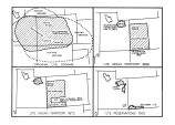
Boundary of Shoshone Indian Territory, showing the locations of the Bannock
1957
Image/StillImage
uaida_main
52
Boundary of Shoshone Indian Territory, showing the locations of the Bannock from 1819 to 1951
1957
Image/StillImage
uaida_main
53
Boundary of Shoshone Indian Territory, showing the locations where the Bannock and Shoshone reported together 1819-1956
1957
Image/StillImage
uaida_main
54
Boundary of Shoshone Indian Territory; Doty Map of 1863 Indian Claims Commission
1957
Image/StillImage
uaida_main
55
Cache Valley Relief Map P.1
Image
dha_cp
56
Camp Floyd Mining District P.1
Image
dha_cp
57
Capitol Building-Exhibits P.1
1920; 1921; 1922; 1923; 1924; 1925; 1926; 1927; 1928; 1929; 1930; 1931; 1932; 1933; 1934; 1935; 1936; 1937; 1938; 1939; 1940; 1941; 1942; 1943; 1944; 1945; 1946; 1947; 1948; 1949; 1950
Image/StillImage
dha_cp
58
Carbon County, Utah P.1
Image
dha_cp
59
Changes of Ute Territory 1868-1972
Text
uaida_main
60
Civic Center, Salt Lake City P.1
Image
dha_cp
61
Clarkston, Utah P.1
Image
dha_cp
62
Colorado Plateau--Map P.1
Image
dha_cp
63
Colorado River (Bishop Map) P.1
Image
dha_cp
64
Colorado River (Upper Basin) P.1
Image
dha_cp
65
Colorado River -- Excursions p.14
1935; 1936; 1937; 1938; 1939; 1940; 1941; 1942; 1943; 1944; 1945
Image/StillImage
dha_cp
66
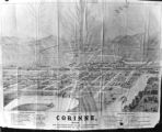
Corinne, Utah P.1
Image
dha_cp
67
Cottonwood Mining District P.1
Image
dha_cp
68
Dry Canyon Ophir Mining District P.1
Image
dha_cp
69
Echo Canyon P.1
Image
dha_cp
70
Echo Canyon P.2
Image
dha_cp
71
Echo Canyon P.3
Image
dha_cp
72
Escalante Map P.1
Image
dha_cp
73
Escalante Route Map P.1
Image
dha_cp
74
Escalante Valley Improvement Company Map
1915-11-19
Image
dha_scp
75
Escalante, Utah--Map P.1
Image
dha_cp
51
-
75
of
185
<
1
2
3
4
5
6
7
8
>