Home
Browse
Ask Us
Chat
Harmful Language Statement
Log in
Advanced Search
Year
1880
1881
1882
1883
1884
1885
1886
1887
1888
1889
1890
1891
1892
1893
1894
1895
1896
1897
1898
1899
1900
1901
1902
1903
1904
1905
1906
1907
1908
1909
1910
1911
1912
1913
1914
1915
1916
1917
1918
1919
1920
1921
1922
1923
1924
1925
1926
1927
1928
1929
1930
1931
1932
1933
1934
1935
1936
1937
1938
1939
1940
1941
1942
1943
1944
1945
1946
1947
1948
1949
1950
1951
1952
1953
1954
1955
1956
1957
1958
1959
1960
1961
1962
1963
1964
1965
1966
1967
1968
1969
1970
1971
1972
1973
1974
1975
1976
1977
1978
1979
1980
1981
1982
1983
1984
1985
1986
1987
1988
1989
1990
1991
1992
1993
1994
1995
1996
1997
TO
1880
1881
1882
1883
1884
1885
1886
1887
1888
1889
1890
1891
1892
1893
1894
1895
1896
1897
1898
1899
1900
1901
1902
1903
1904
1905
1906
1907
1908
1909
1910
1911
1912
1913
1914
1915
1916
1917
1918
1919
1920
1921
1922
1923
1924
1925
1926
1927
1928
1929
1930
1931
1932
1933
1934
1935
1936
1937
1938
1939
1940
1941
1942
1943
1944
1945
1946
1947
1948
1949
1950
1951
1952
1953
1954
1955
1956
1957
1958
1959
1960
1961
1962
1963
1964
1965
1966
1967
1968
1969
1970
1971
1972
1973
1974
1975
1976
1977
1978
1979
1980
1981
1982
1983
1984
1985
1986
1987
1988
1989
1990
1991
1992
1993
1994
1995
1996
1997
Type
Image
880
Image/StillImage
539
Text
30
Format
image/jpeg
1,440
application/pdf
235
Collection
Beckwith Photograph Collection
2
Photo Archives
552
Ski and Snow Sports Archives
14
UAIDA Main Collection
51
Utah River Running Photo Archives
1,059
Western Waters NEH
1
More
Filters:
Spatial Coverage:
"San Juan County (Utah)"
551
-
575
of
1,679
<
18
19
20
21
22
23
24
25
26
27
>
Gallery view
Number of results to display per page
10
25
50
100
200
Sort by Relevance
Sort by Title A-Z
Sort by Title Z-A
Sort by Date Ascending
Sort by Date Descending
Sort by Last Modified Ascending
Sort by Last Modified Descending
Title
Date
Type
Setname
551
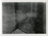
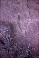
San Juan River, Glen Canyon Expedition, 1942: Petroglyphs
1942
Image/StillImage
uum_map_rr
552
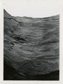
San Juan River, Glen Canyon Expedition, 1942: sandstone walls
1942
Image/StillImage
uum_map_rr
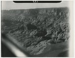
553
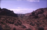
San Juan River, Glen Canyon Expedition, 1942: trail to Rainbow Bridge
1942
Image/StillImage
uum_map_rr
554
Thorn Mayes photos from a flight with Norm Nevills, October 1947 [067]
1947-10
Image/StillImage
uum_map_rr
555
Thorn Mayes photos from a flight with Norm Nevills, October 1947 [068]
1947-10
Image/StillImage
uum_map_rr
556
Thorn Mayes photos from a flight with Norm Nevills, October 1947 [116]
1947-10
Image/StillImage
uum_map_rr
557
Arch Country across from Hole in the Rock
1957; 1958; 1959; 1960; 1961; 1962
uum_map_rr
558
Arch Country across from Hole in the Rock
1957; 1958; 1959; 1960; 1961; 1962
uum_map_rr
559
Arch Country across from Hole in the Rock
1957; 1958; 1959; 1960; 1961; 1962
uum_map_rr
560
Arch Country across from Hole in the Rock
1957; 1958; 1959; 1960; 1961; 1962
uum_map_rr
561
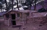
Bert Loper's Homestead.
1957; 1958; 1959; 1960; 1961; 1962
uum_map_rr
562
Camp in San Juan Canyon near mouth of Johns Canyon. Lower Part of wall formed by Goodridge formation and upper part by Moonlight sandstone and Hermit shale. San Juan County, UT. 1921
1921
Image
uum_map
563
Camp scene, south bank of Armstrong Canyon looking northeast. Camp on Coconino; plateau in middle distance. Moenkopi capped by Shinarump; mesa in left background. Chinle and Glen Canyon, Fred Lowrey. San Juan County, UT, 1928
Image
uum_map
564
Looking down Notch Canyon from East Point, Elk Ridge, toward Chimney Park. Cottonwood Canyon in middle distance. Buttes of Navajo beyond Shay Mountains in distance. San Juan County, UT, 1928
Image
uum_map
565
Looking down Notch Canyon from East Point, Elk Ridge, toward Chimney Park. Cottonwood Canyon in middle distance. Buttes of Navajo beyond Shay Mountains in distance. San Juan County, UT, 1928
1928
Image
uum_map
566
Mormon Trail across from Hole in the Rock
1957; 1958; 1959; 1960; 1961; 1962
uum_map_rr
567
Mormon Trail across from Hole in the Rock
1957; 1958; 1959; 1960; 1961; 1962
uum_map_rr
568
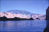
Navajo Mountain.
1957; 1958; 1959; 1960; 1961; 1962
uum_map_rr
569
Rock wall near Bert Loper's Homestead.
1957; 1958; 1959; 1960; 1961; 1962
uum_map_rr
570
Site of Bert Loper's Homestead.
1957; 1958; 1959; 1960; 1961; 1962
uum_map_rr
571
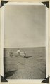
Spring on desert flat at Red House, head of Red Canyon where by recession of cliffs the floor of Red Canyon is nearly on a level with Grand Flats, Marvin Lyman, San Juan County, Utah, 1930.
1930
Image
uum_map
572
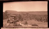
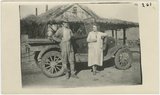
William E. and Mae D. Nevills, "Old Canyon" Camp, Sand Draw Canyon, Mexican Hat, Utah.
Image
uum_map_rr
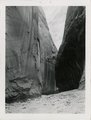
573
Canyon walls
1935; 1936; 1937; 1938; 1939; 1940; 1941; 1942; 1943; 1944; 1945; 1946; 1947; 1948; 1949
Image/StillImage
uum_map_rr
574
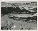
Confluence of San Juan and Colorado Rivers, 1962
1962-06-19
Image
uum_map
575
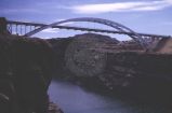
Hite Crossing Bridge over Colorado River, from upstream
1966-07-26
Image
uum_map
551
-
575
of
1,679
<
18
19
20
21
22
23
24
25
26
27
>