Home
Browse
Ask Us
Chat
Harmful Language Statement
Log in
Advanced Search
Year
1875
1876
1877
1878
1879
1880
1881
1882
1883
1884
1885
1886
1887
1888
1889
1890
1891
1892
1893
1894
1895
1896
1897
1898
1899
1900
1901
1902
1903
1904
1905
1906
1907
1908
1909
1910
1911
1912
1913
1914
1915
1916
1917
1918
1919
1920
1921
1922
1923
1924
1925
1926
1927
1928
1929
1930
1931
1932
1933
1934
1935
1936
1937
1938
1939
1940
1941
1942
1943
1944
1945
1946
1947
1948
1949
1950
1951
1952
1953
1954
1955
1956
1957
1958
1959
1960
1961
1962
1963
1964
1965
1966
1967
1968
1969
1970
1971
1972
1973
1974
1975
1976
1977
1978
1979
1980
1981
1982
1983
1984
1985
1986
1987
1988
1989
1990
1991
1992
1993
TO
1875
1876
1877
1878
1879
1880
1881
1882
1883
1884
1885
1886
1887
1888
1889
1890
1891
1892
1893
1894
1895
1896
1897
1898
1899
1900
1901
1902
1903
1904
1905
1906
1907
1908
1909
1910
1911
1912
1913
1914
1915
1916
1917
1918
1919
1920
1921
1922
1923
1924
1925
1926
1927
1928
1929
1930
1931
1932
1933
1934
1935
1936
1937
1938
1939
1940
1941
1942
1943
1944
1945
1946
1947
1948
1949
1950
1951
1952
1953
1954
1955
1956
1957
1958
1959
1960
1961
1962
1963
1964
1965
1966
1967
1968
1969
1970
1971
1972
1973
1974
1975
1976
1977
1978
1979
1980
1981
1982
1983
1984
1985
1986
1987
1988
1989
1990
1991
1992
1993
Type
Image
1,955
Format
image/jpeg
1,687
application/pdf
268
Collection
Beckwith Photograph Collection
2
Photo Archives
1,106
Utah River Running Photo Archives
847
Filters:
Spatial Coverage:
"San Juan County (Utah)"
Type:
"Image"
426
-
450
of
1,955
<
13
14
15
16
17
18
19
20
21
22
>
Gallery view
Number of results to display per page
10
25
50
100
200
Sort by Relevance
Sort by Title A-Z
Sort by Title Z-A
Sort by Date Ascending
Sort by Date Descending
Sort by Last Modified Ascending
Sort by Last Modified Descending
Title
Date
Type
Setname
426
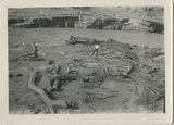
Driftwood by San Juan
1925; 1926; 1927; 1928; 1929; 1930; 1931; 1932; 1933; 1934; 1935; 1936; 1937; 1938; 1939; 1940; 1941; 1942; 1943; 1944; 1945; 1946; 1947; 1948; 1949
Image
uum_map_rr
427
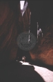
Dungeon Canyon, 1961.
1961
Image
uum_map
428
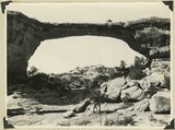
Early morning from Caroline Bridge, Bridges National Monument, UT
1925
Image
uum_map
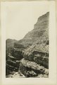
429
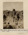
Earth Pillars. Pahute Canyon, Utah, 1910 (Photo G169)
1910
Image
uum_map
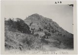
430
East Bears Ear
1930
Image
uum_map_rr
431
East Dome, Mexican Hat
1924-01-11
Image
uum_map_rr
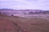
432
East edge of Raplee monocline. San Juan County, UT 1928
1928
Image
uum_map
433
East of Hite, Utah on new graded section
1966-07-26
Image
uum_map
434
East side of Butler Wash, 77 Miles above its mouth. View taken standing on Navajo sandstone. Carmel (?), Entrada (?), Summerville (?), Salt Wahs (?), Morrison Shales, Dakota, San Juan County, Utah, 1928.
Image
uum_map
435
East side of Butler Wash, 77 Miles above its mouth. View taken standing on Navajo sandstone. Carmel (?), Entrada (?), Summerville (?), Salt Wahs (?), Morrison Shales, Dakota, San Juan County, Utah, 1928.
1928
Image
uum_map
436
East wall of Comb Wash includes Chinle, Wingate, Todilto, Navajo near mouth of Arch Canyon. San Juan County, UT. 1925
1925
Image
uum_map
437
Edge of Comb looking SW 2± mi. NW of Garnet Ridge 1914
1914
Image
uum_map
438
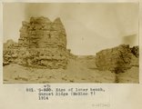
Edge of lower bench, Garnet Ridge (McElmo?), 1914
1914
Image
uum_map
439
Edwin Bridge
1930
Image
uum_map_rr
440
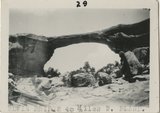
Edwin Bridge looking north
1928-08
Image
uum_map_rr
441
Edwin Bridge or Owachomo Bridge, in Bridges National Monument. The figure is Dan Perkins and his horse Cap
1925
Image
uum_map
442
Edwin Bridge, or Owachomo Bridge, in Bridges National Monument. The figure is Dan Perkins and his horse
1925
Image
uum_map
443
Edwin Bridge, or Owachomo Bridge, in Bridges National Monument. The figure is Dan Perkins and his horse
1925
Image
uum_map
444
Edwin Natural Bridge
1930
Image
uum_map_rr
445
Edwin Natural Bridge
1930
Image
uum_map_rr
446
Elderly men near car.
1958
Image
uum_map
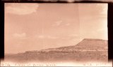
447
Elk Mountain, 1930
1930
Image
uum_map_rr
448
Entrada(?) on back of Comb monocline. Butler Wash, 11 miles above its mouth, maybe a sandstone below Entrada. View taken standing on Navajo. San Juan County, UT, 1928
1928
Image
uum_map
449
Entrada, Carmel (?) Navajo, east side. Allen Canyon near Mancos Jim Butte. San Juan County, UT, 1927
1927
Image
uum_map
450
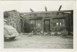
Entrance facade of the Nevills Mexican Hat Lodge beside the San Juan River, opened in 1933.
1936-03
Image
uum_map_rr
426
-
450
of
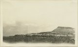
1,955
<
13
14
15
16
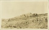
17
18
19
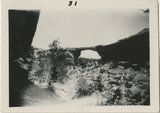
20
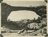
21
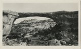
22
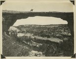
>