Home
Browse
Ask Us
Chat
Harmful Language Statement
Log in
Advanced Search
Year
1875
1876
1877
1878
1879
1880
1881
1882
1883
1884
1885
1886
1887
1888
1889
1890
1891
1892
1893
1894
1895
1896
1897
1898
1899
1900
1901
1902
1903
1904
1905
1906
1907
1908
1909
1910
1911
1912
1913
1914
1915
1916
1917
1918
1919
1920
1921
1922
1923
1924
1925
1926
1927
1928
1929
1930
1931
1932
1933
1934
1935
1936
1937
1938
1939
1940
1941
1942
1943
1944
1945
1946
1947
1948
1949
1950
1951
1952
1953
1954
1955
1956
1957
1958
1959
1960
1961
1962
1963
1964
1965
1966
1967
1968
1969
1970
1971
1972
1973
1974
1975
1976
1977
1978
1979
1980
1981
1982
1983
1984
1985
1986
1987
1988
1989
1990
1991
1992
1993
TO
1875
1876
1877
1878
1879
1880
1881
1882
1883
1884
1885
1886
1887
1888
1889
1890
1891
1892
1893
1894
1895
1896
1897
1898
1899
1900
1901
1902
1903
1904
1905
1906
1907
1908
1909
1910
1911
1912
1913
1914
1915
1916
1917
1918
1919
1920
1921
1922
1923
1924
1925
1926
1927
1928
1929
1930
1931
1932
1933
1934
1935
1936
1937
1938
1939
1940
1941
1942
1943
1944
1945
1946
1947
1948
1949
1950
1951
1952
1953
1954
1955
1956
1957
1958
1959
1960
1961
1962
1963
1964
1965
1966
1967
1968
1969
1970
1971
1972
1973
1974
1975
1976
1977
1978
1979
1980
1981
1982
1983
1984
1985
1986
1987
1988
1989
1990
1991
1992
1993
Type
Image
1,955
Format
image/jpeg
1,687
application/pdf
268
Collection
Beckwith Photograph Collection
2
Photo Archives
1,106
Utah River Running Photo Archives
847
Filters:
Spatial Coverage:
"San Juan County (Utah)"
Type:
"Image"
351
-
375
of
1,955
<
10
11
12
13
14
15
16
17
18
19
>
Gallery view
Number of results to display per page
10
25
50
100
200
Sort by Relevance
Sort by Title A-Z
Sort by Title Z-A
Sort by Date Ascending
Sort by Date Descending
Sort by Last Modified Ascending
Sort by Last Modified Descending
Title
Date
Type
Setname
351
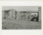
Construction view of the Nevills Mexican Hat Lodge beside the San Juan River, opened in 1933. View with Navajo construction workers.
1932; 1933
Image
uum_map_rr
352
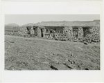
Construction view of the Nevills Mexican Hat Lodge beside the San Juan River, opened in 1933. William E. Nevills in the foreground.
1932; 1933
Image
uum_map_rr
353
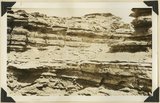
Contact between Mancos shale and igneous rock, at head of Harts Draw, Abajo Mountain. Utah, San Juan, 1915.
1915
Image
uum_map
354
Contact between Mancos shale and igneous rock, head of Harts Draw Wash, Abajo Mountains. Utah, San Juan, 1915.
1915
Image
uum_map
355
Contact De Chelly and Moenkopi formations at Rasp Trail lower White Canyon. San Juan County, Utah, 1932.
1932
Image
uum_map
356
Contact Navajo and McElmo, Dry Wash, San Juan County, UT, 1925
1925
Image
uum_map
357
Contact of "Frey" (Organ Rock) and De Chelly formations south side White Canyon below Star Springs, San Juan County, Utah, 1932.
1932
Image
uum_map
358
Contact of LaPlata and McElmo (?) or Dakokta (?) (Photo G357)
1913
Image
uum_map
359
Contact of Moenkopi (right) with shales occupying the position of the Coconino (left). San Juan County, UT, 1928
1928
Image
uum_map
360
Contact of Supai (left) and shales occupying the position of the Coconino. Comb Wash in background. San Juan County, UT, 1928
Image
uum_map
361
Contact of Supai (left) and shales occupying the position of the Coconino. Comb Wash in background. San Juan County, UT, 1928
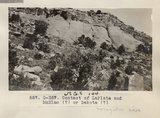
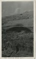
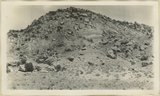
1928
Image
uum_map
362
Cottonwood Canyon, Beef Basin and North Elks, looking west from West Mountain. Abajo Mountains. Utah, San Juan, 1915.
1915
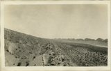
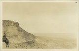
Image
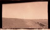
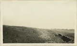
uum_map
363
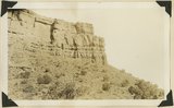
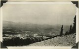
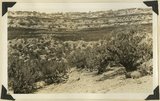
Cow Canyon, Utah, 1929
1939
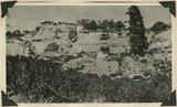
Image
uum_map_rr
364
Crest of Clay Hills Divide cut in Chinle strata: looking east toward Grand Gulch. San Juan County, UT, 1925
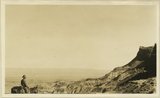
1925
Image
uum_map
365
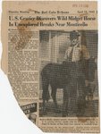
Crest of Clay Hills Divide cut in Chinle strata: looking east toward Grand Gulch. San Juan County, UT, 1925
1925
Image
uum_map
366
Cross-bedding in Moencopie, capped by Shinarump, Oljato, Utah, 1910.
1910
Image
uum_map
367
Cutler (Halgaito) underlying bedded "Kachina" (Cedar Mesa) sandstone Johns Canyon, San Juan County, Utah, 1932.
1932
Image
uum_map
368
Dakota cliff, east wall of Bulldog Canyon. Abajo Mountains. Utah, San Juan, 1915.
1915
Image
uum_map
369
Dakota hogback, first south of Pole Creek, leading up to Abajo Peak. Holmes and party rode up this ridge in 1873. Abajo Mountains. Utah, San Juan, 1915.
1915
Image
uum_map
370
Dakota on Morrison, North end of Black Mesa, west side of Cottonwood Canyon. San Juan County, UT, 1927
1927
Image
uum_map
371
Dakota sandstone (detail), Johnson Creek near stamp mill. Abajo Mountains, Utah, San Juan, 1915.
1915
Image
uum_map
372
Dalton Meeks and midget horse
1945
Image
uum_map
373
Darryl Milczarek, Gregg Dimmitt
1954; 1955; 1956; 1957; 1958; 1959; 1960; 1961
Image
uum_map_rr
374
Dave Hardy, __?__, Shauna Garrett, Mary Ann Brown, Chris Paulsen, David Thompson, Bob Taggart, David Milczarek
1954; 1955; 1956; 1957; 1958; 1959; 1960; 1961
Image
uum_map_rr
375
David Thompson
1954; 1955; 1956; 1957; 1958; 1959; 1960; 1961
Image
uum_map_rr
351
-
375
of
1,955
<
10
11
12
13
14
15
16
17
18
19
>