Home
Browse
Ask Us
Chat
Harmful Language Statement
Log in
Advanced Search
Year
1875
1876
1877
1878
1879
1880
1881
1882
1883
1884
1885
1886
1887
1888
1889
1890
1891
1892
1893
1894
1895
1896
1897
1898
1899
1900
1901
1902
1903
1904
1905
1906
1907
1908
1909
1910
1911
1912
1913
1914
1915
1916
1917
1918
1919
1920
1921
1922
1923
1924
1925
1926
1927
1928
1929
1930
1931
1932
1933
1934
1935
1936
1937
1938
1939
1940
1941
1942
1943
1944
1945
1946
1947
1948
1949
1950
1951
1952
1953
1954
1955
1956
1957
1958
1959
1960
1961
1962
1963
1964
1965
1966
1967
1968
1969
1970
1971
1972
1973
1974
1975
1976
1977
1978
1979
1980
1981
1982
1983
1984
1985
1986
1987
1988
1989
1990
1991
1992
1993
TO
1875
1876
1877
1878
1879
1880
1881
1882
1883
1884
1885
1886
1887
1888
1889
1890
1891
1892
1893
1894
1895
1896
1897
1898
1899
1900
1901
1902
1903
1904
1905
1906
1907
1908
1909
1910
1911
1912
1913
1914
1915
1916
1917
1918
1919
1920
1921
1922
1923
1924
1925
1926
1927
1928
1929
1930
1931
1932
1933
1934
1935
1936
1937
1938
1939
1940
1941
1942
1943
1944
1945
1946
1947
1948
1949
1950
1951
1952
1953
1954
1955
1956
1957
1958
1959
1960
1961
1962
1963
1964
1965
1966
1967
1968
1969
1970
1971
1972
1973
1974
1975
1976
1977
1978
1979
1980
1981
1982
1983
1984
1985
1986
1987
1988
1989
1990
1991
1992
1993
Type
Image
1,948
Format
image/jpeg
1,680
application/pdf
268
Collection
Beckwith Photograph Collection
2
Photo Archives
1,106
Utah River Running Photo Archives
840
Filters:
Spatial Coverage:
"San Juan County (Utah)"
Type:
"Image"
326
-
350
of
1,948
<
9
10
11
12
13
14
15
16
17
18
>
Gallery view
Number of results to display per page
10
25
50
100
200
Sort by Relevance
Sort by Title A-Z
Sort by Title Z-A
Sort by Date Ascending
Sort by Date Descending
Sort by Last Modified Ascending
Sort by Last Modified Descending
Title
Date
Type
Setname
326
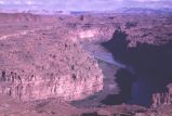
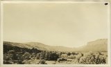
Colorado River canyonlands southwest of Moab [8]
1960-10-25
Image
uum_map
327
Colorado River in Glen Canyon, Navajo Mountain in background
1937; 1938; 1939; 1940; 1941; 1942; 1943; 1944; 1945; 1946; 1947; 1948; 1949; 1950; 1951; 1952; 1953; 1954; 1955; 1956; 1957; 1958; 1959; 1960; 1961; 1962; 1963; 1964; 1965; 1966; 1967; 1968; 1969; 1970; 1971; 1972; 1973; 1974; 1975; 1976; 1977; 1978; 1979; 1980
Image
uum_map_rr
328
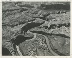
Colorado River looking down stream from the mouth of Moki Canyon (at the left).
1930; 1931; 1932; 1933; 1934; 1935; 1936; 1937
Image
uum_map
329
Colorado River looking up stream from the mouth of Moki Canyon.
1930; 1931; 1932; 1933; 1934; 1935; 1936; 1937
Image
uum_map
330
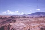
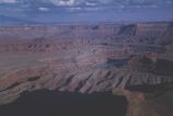
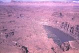
Colorado River near Moab, Utah: view from Dead Horse Point [1]
1940; 1941; 1942; 1943; 1944; 1945; 1946; 1947; 1948; 1949; 1950; 1951; 1952; 1953; 1954; 1955; 1956; 1957; 1958; 1959; 1960; 1961; 1962; 1963; 1964; 1965; 1966; 1967; 1968; 1969; 1970
Image
uum_map_rr
331
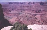
Colorado River near Moab, Utah: view from Dead Horse Point [2]
1940; 1941; 1942; 1943; 1944; 1945; 1946; 1947; 1948; 1949; 1950; 1951; 1952; 1953; 1954; 1955; 1956; 1957; 1958; 1959; 1960; 1961; 1962; 1963; 1964; 1965; 1966; 1967; 1968; 1969; 1970
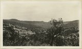
Image
uum_map_rr
332
Colorado River near Moab, Utah: view from Dead Horse Point [3]
1940; 1941; 1942; 1943; 1944; 1945; 1946; 1947; 1948; 1949; 1950; 1951; 1952; 1953; 1954; 1955; 1956; 1957; 1958; 1959; 1960; 1961; 1962; 1963; 1964; 1965; 1966; 1967; 1968; 1969; 1970
Image
uum_map_rr
333
Colorado River near Moab, Utah: view from Dead Horse Point [4]
1940; 1941; 1942; 1943; 1944; 1945; 1946; 1947; 1948; 1949; 1950; 1951; 1952; 1953; 1954; 1955; 1956; 1957; 1958; 1959; 1960; 1961; 1962; 1963; 1964; 1965; 1966; 1967; 1968; 1969; 1970
Image
uum_map_rr
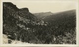
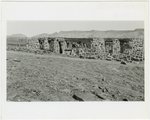
334
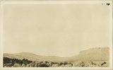
Comb monocline from Blanding-Kigalia road. Chinle capped by Wingate in left front Shinarump cap at right sloping up to Elk Ridge. San Juan County, UT, 1927
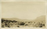
1927
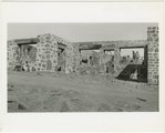
Image
uum_map
335
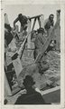
Comb monocline left Kaibab, valley floor and end Moenkopi. Shinarump right. Chinle slopes capped by Wingate. Shinarump caps Elk Ridge high point in left background. View looking north from mouth of Arch Canyon. San Juan County, UT, 1925
1925
Image
uum_map
336
Comb monocline left Kaibab, valley floor and end Moenkopi. Shinarump right. Chinle slopes capped by Wingate. Shinarump caps Elk Ridge high point in left background. View looking north from mouth of Arch Canyon. San Juan County, UT, 1925
1925
Image
uum_map
337
Comb monocline left Kaibab, valley floor and end Moenkopi. Shinarump right. Chinle slopes capped by Wingate. Shinarump caps Elk Ridge high point in left background. View looking north from mouth of Arch Canyon. San Juan County, UT, 1925
1925
Image
uum_map
338
Comb monocline looking north from Hammond Canyon. Coconino (?), Moenkopi, Shinarump. San Juan County, UT, 1927
1927
Image
uum_map
339
Comb monocline looking north from Hammond Canyon. Coconino (?), Moenkopi, Shinarump. San Juan County, UT, 1927
1927
Image
uum_map
340
Comb Ridge, San Juan Co.,, Ut.
1929
Image
uum_map
341
Comb Ridge, San Juan Co.,, Ut., 1929
1929
Image
uum_map
342
Comb Wash
1920; 1921; 1922; 1923; 1924; 1925; 1926; 1927; 1928; 1929; 1930; 1931; 1932; 1933; 1934; 1935; 1936; 1937; 1938; 1939; 1940; 1941; 1942; 1943; 1944; 1945; 1946; 1947; 1948; 1949
Image
uum_map_rr
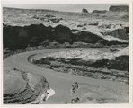
343
Confluence of San Juan and Colorado Rivers, 1962
1962-06-19
Image
uum_map
344
Confluence of San Juan and Colorado Rivers, 1963
1963-02-26
Image
uum_map
345
Construction view of the Nevills Mexican Hat Lodge beside the San Juan River, opened in 1933.
1932; 1933
Image
uum_map_rr
346
Construction view of the Nevills Mexican Hat Lodge beside the San Juan River, opened in 1933.
1932; 1933
Image
uum_map_rr
347
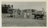
Construction view of the Nevills Mexican Hat Lodge beside the San Juan River, opened in 1933. Left to right: William E. Nevills, Thom Mayes, Norman D. Nevills, (?), and Doris Drown Nevills.
1932; 1933
Image
uum_map_rr
348
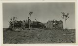
Construction view of the Nevills Mexican Hat Lodge beside the San Juan River, opened in 1933. View of Navajo construction workers.
1932; 1933
Image
uum_map_rr
349
Construction view of the Nevills Mexican Hat Lodge beside the San Juan River, opened in 1933. View with Navajo construction workers.
1932; 1933
Image
uum_map_rr
350
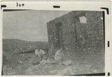
Construction view of the Nevills Mexican Hat Lodge beside the San Juan River, opened in 1933. William E. Nevills in the foreground.
1932; 1933
Image
uum_map_rr
326
-
350
of
1,948
<
9
10
11
12
13
14
15
16
17
18
>