| Title | Date | Type | Setname | ||
|---|---|---|---|---|---|
| 126 |  | Map showing the boundary of the Shoshone Indian territory | 1941 | Image/StillImage | uaida_main |
| 127 |  | Marion County Urban Growth Management Project: Phase I and II Report | 2001-06 | Text | uu_lu_tsp |
| 128 |  | Modeling Analysis of Willamette Valley Transportation and Land Use Alternatives | 2001-06 | Text | uu_lu_tsp |
| 129 |  | Modeling streamflow and water temperature in the North Santiam And Santiam Rivers, Oregon, 2001-02 | 2004 | Text | wwdl_er |
| 130 |  | Modeling water quality in the Tualatin River, Oregon, 1991-1997 | 2001 | Text | wwdl_er |
| 131 |  | Monitoring instream turbidity to estimate continuous suspended-sediment loads and yields and clay-water volumes in the Upper North Santiam River Basin, Oregon, 1998-2000 | 2003 | Text | wwdl_er |
| 132 | 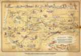 | Mormon Trail map | 1947 | Image/StillImage | uum_tawp |
| 133 |  | MS Random | 1997; 1998; 1999; 2000; 2001; 2002 | Image | uum_map_usa |
| 134 |  | MS Random | 1997; 1998; 1999; 2000; 2001; 2002 | Image | uum_map_usa |
| 135 |  | MS Random | 1997; 1998; 1999; 2000; 2001; 2002 | Image | uum_map_usa |
| 136 |  | MS Random | 1997; 1998; 1999; 2000; 2001; 2002 | Image | uum_map_usa |
| 137 |  | MS Random | 1997; 1998; 1999; 2000; 2001; 2002 | Image | uum_map_usa |
| 138 |  | MS Random | 1997; 1998; 1999; 2000; 2001; 2002 | Image | uum_map_usa |
| 139 |  | MS Random | 1997; 1998; 1999; 2000; 2001; 2002 | Image | uum_map_usa |
| 140 |  | MS Random | 1997; 1998; 1999; 2000; 2001; 2002 | Image | uum_map_usa |
| 141 |  | MS Random | 1997; 1998; 1999; 2000; 2001; 2002 | Image | uum_map_usa |
| 142 |  | MS Random | 1997; 1998; 1999; 2000; 2001; 2002 | Image | uum_map_usa |
| 143 |  | MS Random | 1997; 1998; 1999; 2000; 2001; 2002 | Image | uum_map_usa |
| 144 |  | MS Random | 1997; 1998; 1999; 2000; 2001; 2002 | Image | uum_map_usa |
| 145 |  | MS Random | 1997; 1998; 1999; 2000; 2001; 2002 | Image | uum_map_usa |
| 146 |  | MS Random | 1997; 1998; 1999; 2000; 2001; 2002 | Image | uum_map_usa |
| 147 |  | MS Random | 1997; 1998; 1999; 2000; 2001; 2002 | Image | uum_map_usa |
| 148 |  | MS Random | 1997; 1998; 1999; 2000; 2001; 2002 | Image | uum_map_usa |
| 149 |  | MS Random | 1997; 1998; 1999; 2000; 2001; 2002 | Image | uum_map_usa |
| 150 |  | MS Random | 1997; 1998; 1999; 2000; 2001; 2002 | Image | uum_map_usa |