Home
Browse
Ask Us
Chat
Harmful Language Statement
Log in
Advanced Search
Year
1846
1847
1848
1849
1850
1851
1852
1853
1854
1855
1856
1857
1858
1859
1860
1861
1862
1863
1864
1865
1866
1867
1868
1869
1870
1871
1872
1873
1874
1875
1876
1877
1878
1879
1880
1881
1882
1883
1884
1885
1886
1887
1888
1889
1890
1891
1892
1893
1894
1895
1896
1897
1898
1899
1900
1901
1902
1903
1904
1905
1906
1907
1908
1909
1910
1911
1912
1913
1914
1915
1916
1917
1918
1919
1920
1921
1922
1923
1924
1925
1926
1927
1928
1929
1930
1931
1932
1933
1934
1935
1936
1937
1938
1939
1940
1941
1942
1943
1944
1945
1946
1947
1948
1949
1950
1951
1952
1953
1954
1955
1956
1957
TO
1846
1847
1848
1849
1850
1851
1852
1853
1854
1855
1856
1857
1858
1859
1860
1861
1862
1863
1864
1865
1866
1867
1868
1869
1870
1871
1872
1873
1874
1875
1876
1877
1878
1879
1880
1881
1882
1883
1884
1885
1886
1887
1888
1889
1890
1891
1892
1893
1894
1895
1896
1897
1898
1899
1900
1901
1902
1903
1904
1905
1906
1907
1908
1909
1910
1911
1912
1913
1914
1915
1916
1917
1918
1919
1920
1921
1922
1923
1924
1925
1926
1927
1928
1929
1930
1931
1932
1933
1934
1935
1936
1937
1938
1939
1940
1941
1942
1943
1944
1945
1946
1947
1948
1949
1950
1951
1952
1953
1954
1955
1956
1957
Type
Image/StillImage
10
Format
image/jpeg
9
application/pdf
1
Collection
American Westward Migration
2
Photo Archives
1
Taylor A. Woolley Papers
2
UAIDA Main Collection
4
Utah River Running Photo Archives
1
Filters:
Spatial Coverage:
"Oregon"
Type:
"Image/StillImage"
1
-
25
of
10
Gallery view
Number of results to display per page
10
25
50
100
200
Sort by Relevance
Sort by Title A-Z
Sort by Title Z-A
Sort by Date Ascending
Sort by Date Descending
Sort by Last Modified Ascending
Sort by Last Modified Descending
Title
Date
Type
Setname
1
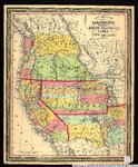
New map of the state of California, the territories of Oregon, Washington, Utah & New Mexico.
1853
Image/StillImage
uu_awm
2
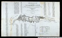
Topographical Map of the Road From Missouri To Oregon Commencing at the Mouth of the Kansas in the Missouri River and Ending at the Mouth of the Wallah-Wallah in the Columbia. Section 7
1846
Image/StillImage
uu_awm
3
Map of Western Shoshone and Northern Paiute Territory
Image/StillImage
uaida_main
4
Map of Western Indian Territory Before 1850
Image/StillImage
uaida_main
5
Map showing the boundary of the Shoshone Indian territory
1941
Image/StillImage
uaida_main
6
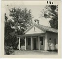
Oregon City school house where I attended school: Mae Davis Nevills
1925
Image/StillImage
uum_map_rr
7
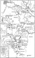
Map of Shoshone, Goshute, Bannock, Wind River and Panamint Indian Tribal Groups
1957
Image/StillImage
uaida_main
8
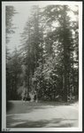
Oregon-California auto trip, 1921: Columbia River Drive - East of Portland
1921
Image/StillImage
uum_map
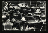
9
Route of the Mormon Pioneers map
1947
Image/StillImage
uum_tawp
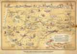
10
Mormon Trail map
1947
Image/StillImage
uum_tawp
1
-
25
of
10