Home
Browse
Ask Us
Chat
Harmful Language Statement
Log in
Advanced Search
Year
1911
1912
1913
1914
1915
1916
1917
1918
1919
1920
1921
1922
1923
1924
1925
1926
1927
1928
1929
1930
1931
1932
1933
1934
1935
1936
1937
1938
1939
1940
1941
1942
1943
1944
1945
1946
1947
1948
1949
1950
1951
1952
1953
1954
1955
1956
1957
1958
1959
1960
1961
1962
1963
1964
1965
1966
1967
1968
1969
1970
1971
1972
1973
1974
1975
1976
1977
1978
1979
1980
1981
1982
1983
1984
1985
1986
1987
1988
1989
1990
1991
1992
1993
1994
1995
1996
1997
1998
1999
2000
2001
2002
2003
2004
2005
2006
2007
2008
2009
2010
2011
2012
2013
2014
2015
2016
2017
2018
2019
2020
TO
1911
1912
1913
1914
1915
1916
1917
1918
1919
1920
1921
1922
1923
1924
1925
1926
1927
1928
1929
1930
1931
1932
1933
1934
1935
1936
1937
1938
1939
1940
1941
1942
1943
1944
1945
1946
1947
1948
1949
1950
1951
1952
1953
1954
1955
1956
1957
1958
1959
1960
1961
1962
1963
1964
1965
1966
1967
1968
1969
1970
1971
1972
1973
1974
1975
1976
1977
1978
1979
1980
1981
1982
1983
1984
1985
1986
1987
1988
1989
1990
1991
1992
1993
1994
1995
1996
1997
1998
1999
2000
2001
2002
2003
2004
2005
2006
2007
2008
2009
2010
2011
2012
2013
2014
2015
2016
2017
2018
2019
2020
Type
Image
21
Text
1
Format
image/jpeg
19
application/pdf
2
Collection
Photo Archives
20
Westminster University COVID-19 Digit...
1
Filters:
Spatial Coverage:
"New Zealand"
Type:
"Image"
1
-
25
of
21
Gallery view
Number of results to display per page
10
25
50
100
200
Sort by Relevance
Sort by Title A-Z
Sort by Title Z-A
Sort by Date Ascending
Sort by Date Descending
Sort by Last Modified Ascending
Sort by Last Modified Descending
Title
Date
Type
Setname
1
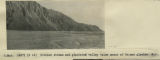
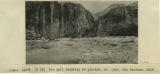
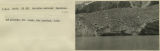
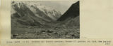
Braided stream and glaciated valley below snout of Tasman glacier, N.Z.
1916
Image
uum_map
2
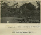
End of glacier, Mt. Cook, New Zealand, 1916
1916
Image
uum_map
3
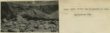
End of glacier: till banks
1916
Image
uum_map
4
Fault graben formed at time of earthquake, Wellington, New Zealand, 1916
1916
Image
uum_map
5
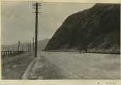
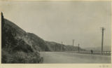
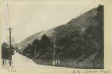
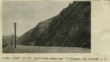
Fault line scarp, Wellington & Lower Heath, N.Z. [1]
1916
Image
uum_map
6
Fault line scarp, Wellington & Lower Heath, N.Z. [2]
1916
Image
uum_map
7
Fault line scarp, Wellington & Lower Heath, N.Z. [3]
1916
Image
uum_map
8
Fault line scarp, Wellington & Lower Heath, N.Z. [4]
1916
Image
uum_map
9
Fault-line scarp near Wellington, New Zealand, 1916
1916
Image
uum_map
10
Herbert E. Gregory Book 13: Photographs taken on Yale Peruvian Expeditions, 1911-1915
1911; 1912; 1913; 1914; 1915; 1916; 1926
Image
uum_map
11
Ice wall terminus of glacier, Mt. Cook, New Zealand, 1916
1916
Image
uum_map
12
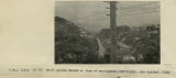
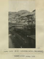
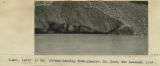
Lyttleton Harbor
1916
Image
uum_map
13
Lyttleton Harbor, New Zealand, inside ancient crater, 1916
1916
Image
uum_map
14
Moraine covered terminus of glacier, Mt. Cook, New Zealand, 1916
1916
Image
uum_map
15
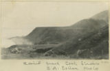
Moraine, Mt. Cook, N.Z.
1916
Image
uum_map
16
My Time in New Zealand during the 2020 Pandemic
2020
Text; Image
wc_cdc
17
Old and new lateral moraine below Tasman glacier, New Zealand, 1916
1916
Image
uum_map
18
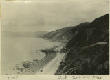
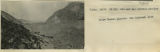
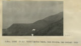
Raised beach, Cook Straits,
1916
Image
uum_map
19
Raised marine beach, Cook Straits, New Zealand, 1916
1916
Image
uum_map
20
Stream issuing from glacier, Mt. Cook, New Zealand, 1916
1916
Image
uum_map
21
Terminal and lateral moraines, Hooker(?) glacier, Mt. Cook, New Zealand, 1916
1916
Image
uum_map
1
-
25
of
21