Home
Browse
Ask Us
Chat
Harmful Language Statement
Log in
Advanced Search
Year
1871
1872
1873
1874
1875
1876
1877
1878
1879
1880
1881
1882
1883
1884
1885
1886
1887
1888
1889
1890
1891
1892
1893
1894
1895
1896
1897
1898
1899
1900
1901
1902
1903
1904
1905
1906
1907
1908
1909
1910
1911
1912
1913
1914
1915
1916
1917
1918
1919
1920
1921
1922
1923
1924
1925
1926
1927
1928
1929
1930
1931
1932
1933
1934
1935
1936
1937
1938
1939
1940
1941
1942
1943
1944
1945
1946
1947
1948
1949
1950
1951
1952
1953
1954
1955
1956
1957
1958
1959
1960
1961
1962
1963
1964
1965
1966
1967
1968
1969
1970
1971
1972
1973
1974
1975
1976
1977
1978
1979
1980
1981
1982
1983
1984
1985
1986
1987
1988
1989
1990
1991
1992
1993
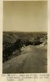
1994
1995
1996
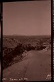
1997
1998
1999
2000
2001
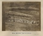
2002
2003
2004
2005
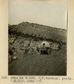
TO
1871
1872
1873
1874
1875
1876
1877
1878
1879
1880
1881
1882
1883
1884
1885
1886
1887
1888
1889
1890
1891
1892
1893
1894
1895
1896
1897
1898
1899
1900
1901
1902
1903
1904
1905
1906
1907
1908
1909
1910
1911
1912
1913
1914
1915
1916
1917
1918
1919
1920
1921
1922
1923
1924
1925
1926
1927
1928
1929
1930
1931
1932
1933
1934
1935
1936
1937
1938
1939
1940
1941
1942
1943
1944
1945
1946
1947
1948
1949
1950
1951
1952
1953
1954
1955
1956
1957
1958
1959
1960
1961
1962
1963
1964
1965
1966
1967
1968
1969
1970
1971
1972
1973
1974
1975
1976
1977
1978
1979
1980
1981
1982
1983
1984
1985
1986
1987
1988
1989
1990
1991
1992
1993
1994
1995
1996
1997
1998
1999
2000
2001
2002
2003
2004
2005
Type
Image
210
Text
2
Format
image/jpeg
189
application/pdf
19
Collection
Beckwith Photograph Collection
9
Classified Photographs
53
Photo Archives
144
Utah River Running Photo Archives
2
Western Waters Electronic Resources
2
Filters:
Spatial Coverage:
"New Mexico"
Type:
"Image"
126
-
150
of
210
<
1
2
3
4
5
6
7
8
9
>
Gallery view
Number of results to display per page
10
25
50
100
200
Sort by Relevance
Sort by Title A-Z
Sort by Title Z-A
Sort by Date Ascending
Sort by Date Descending
Sort by Last Modified Ascending
Sort by Last Modified Descending
Title
Date
Type
Setname
126
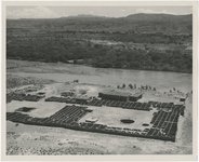
New Mexico, Indian ruins
1945; 1946; 1947; 1948; 1949; 1950; 1951; 1952; 1953; 1954; 1955; 1956; 1957; 1958; 1959; 1960; 1961; 1962; 1963; 1964; 1965
Image
uum_map
127
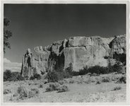
New Mexico, Rock Formations
1945; 1946; 1947; 1948; 1949; 1950; 1951; 1952; 1953; 1954; 1955; 1956; 1957; 1958; 1959; 1960; 1961; 1962; 1963; 1964; 1965
Image
uum_map
128
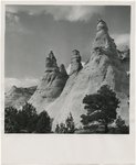
New Mexico, Rock formations near Gallup
1945; 1946; 1947; 1948; 1949; 1950; 1951; 1952; 1953; 1954; 1955; 1956; 1957; 1958; 1959; 1960; 1961; 1962; 1963; 1964; 1965
Image
uum_map
129
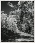
New Mexico, Scenery
1945; 1946; 1947; 1948; 1949; 1950; 1951; 1952; 1953; 1954; 1955; 1956; 1957; 1958; 1959; 1960; 1961; 1962; 1963; 1964; 1965
Image
uum_map
130
New Mexico, Taos
1945; 1946; 1947; 1948; 1949; 1950; 1951; 1952; 1953; 1954; 1955; 1956; 1957; 1958; 1959; 1960; 1961; 1962; 1963; 1964; 1965
Image
uum_map
131
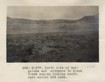
North side of Baigaiche and entrance to Black Creek canyon looking southeast across Red Lake (Photo G377)
1913
Image
uum_map
132
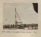
Oil well, Seven Lakes. 1911 (Photo G302)
1911
Image
uum_map
133
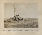
Oil wells, Seven Lakes. 1911 (Photo G300)
1911
Image
uum_map
134
On Santa Fe RR, New Mexico 1900
1900
Image
uum_map
135
Page and Mary Stegner, New Mexico (?)
1941; 1942; 1943; 1944; 1945; 1946; 1947
Image
uum_map
136
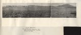
Panorama, Red Wall and Baigaiche, looking across Red Lake (Photo G-378-380)
1913
Image
uum_map
137
Panorama, Red Wall and Baigaiche, looking across Red Lake (Photo G-378-380)
1913
Image
uum_map
138
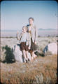
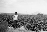
Photographs from the manuscript: "Mormon Towns and Trails: Followed by Gaskell Romney, with his parents in the 1880's, and with his his children in 1941." - "Bob, in cotton field in Las Cruces."
1941
Image
uum_map
139
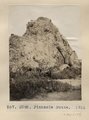
Pinnacle Butte. 1911 (Photo G292)
1911
Image
uum_map
140
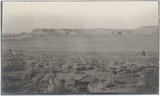
Red lake, north of Fort Defiance, looking south. Volcanic neck at base of lake in background. Heald, photo. 1911 (Photo G216)
1911
Image
uum_map
141
Rio Grande ruins at Albuquerque N.M. 1900, effect of flood
1900
Image
uum_map
142
The Rocky Mountain Climate Organization
Image; Text
wwdl_er
143
Same as G-104 (Fort Defiance-Tolhatchie road), looking northeast, Choiskai Mt. in distance, 1909, negative foir photo G-105)
1909
Image
uum_map
144
Same as G-104 (Fort Defiance-Tolhatchie road), looking northeast, Choiskai Mt. in distance, 1909, photo G-105)
1909
Image
uum_map
145
Same as G-105 (Fort Defiance-Tolhatchie road), U.S.G.S. photo from 1906
1909
Image
uum_map
146
Same as Photo N-M132 (Photo N-M132a)
1911
Image
uum_map
147
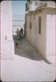
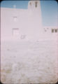
San Esteban del Rey Mission Church and Convent, Acoma Pueblo
1941; 1942; 1943; 1944; 1945; 1946; 1947
Image
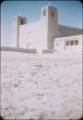
uum_map
148
San Esteban del Rey Mission Church and Convent, Acoma Pueblo
1941; 1942; 1943; 1944; 1945; 1946; 1947
Image
uum_map
149
San Esteban del Rey Mission Church and Convent, Acoma Pueblo
1941; 1942; 1943; 1944; 1945; 1946; 1947
Image
uum_map
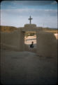
150
San Esteban Del Rey Mission gate, Acoma Pueblo
1941; 1942; 1943; 1944; 1945; 1946; 1947
Image
uum_map
126
-
150
of
210
<
1
2
3
4
5
6
7
8
9
>