Home
Browse
Ask Us
Chat
Harmful Language Statement
Log in
Advanced Search
Year
1871
1872
1873
1874
1875
1876
1877
1878
1879
1880
1881
1882
1883
1884
1885
1886
1887
1888
1889
1890
1891
1892
1893
1894
1895
1896
1897
1898
1899
1900
1901
1902
1903
1904
1905
1906
1907
1908
1909
1910
1911
1912
1913
1914
1915
1916
1917
1918
1919
1920
1921
1922
1923
1924
1925
1926
1927
1928
1929
1930
1931
1932
1933
1934
1935
1936
1937
1938
1939
1940
1941
1942
1943
1944
1945
1946
1947
1948
1949
1950
1951
1952
1953
1954
1955
1956
1957
1958
1959
1960
1961
1962
1963
1964
1965
1966
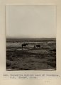
1967
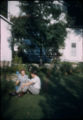
1968
1969
1970
1971
1972
1973
1974
1975
1976
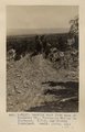
1977
1978
1979
1980
1981
1982
1983
1984
1985
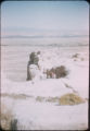
1986
1987
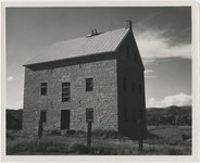
1988
1989
1990
1991
1992
1993
1994
1995
1996
1997
1998
1999
2000
2001
2002
2003
2004
2005
TO
1871
1872
1873
1874
1875
1876
1877
1878
1879
1880
1881
1882
1883
1884
1885
1886
1887
1888
1889
1890
1891
1892
1893
1894
1895
1896
1897
1898
1899
1900
1901
1902
1903
1904
1905
1906
1907
1908
1909
1910
1911
1912
1913
1914
1915
1916
1917
1918
1919
1920
1921
1922
1923
1924
1925
1926
1927
1928
1929
1930
1931
1932
1933
1934
1935
1936
1937
1938
1939
1940
1941
1942
1943
1944
1945
1946
1947
1948
1949
1950
1951
1952
1953
1954
1955
1956
1957
1958
1959
1960
1961
1962
1963
1964
1965
1966
1967
1968
1969
1970
1971
1972
1973
1974
1975
1976
1977
1978
1979
1980
1981
1982
1983
1984
1985
1986
1987
1988
1989
1990
1991
1992
1993
1994
1995
1996
1997
1998
1999
2000
2001
2002
2003
2004
2005
Type
Image
210
Text
2
Format
image/jpeg
189
application/pdf
19
Collection
Beckwith Photograph Collection
9
Classified Photographs
53
Photo Archives
144
Utah River Running Photo Archives
2
Western Waters Electronic Resources
2
Filters:
Spatial Coverage:
"New Mexico"
Type:
"Image"
101
-
125
of
210
<
1
2
3
4
5
6
7
8
9
>
Gallery view
Number of results to display per page
10
25
50
100
200
Sort by Relevance
Sort by Title A-Z
Sort by Title Z-A
Sort by Date Ascending
Sort by Date Descending
Sort by Last Modified Ascending
Sort by Last Modified Descending
Title
Date
Type
Setname
101
Lava lying on Tertiary, Cottonwood Pass, Choiskai Mesa, east of Manning's store, NM. Shaler, photo
1890; 1891; 1892; 1893; 1894; 1895; 1896; 1897; 1898; 1899; 1900; 1901; 1902; 1903; 1904; 1905
Image
uum_map
102
Lava remnants and Mesaverde sandstone-capped mesas, looking north 35° west from 3 mi. north of mouth of Cottonwood Arroyo, NM. Shiprock farthest peaks to left. Shaler, photo
1890; 1891; 1892; 1893; 1894; 1895; 1896; 1897; 1898; 1899; 1900; 1901; 1902; 1903; 1904; 1905
Image
uum_map
103
Looking east from base of Choiskai Mt., Tohatchie valley in distance. H.E.G. and Grover Cleveland. Heald, photo. 1911 (Photo N-M110)
1911
Image
uum_map
104
Manuelito Springs east of Tohatchie, N.M. Shaler, photo
1911
Image
uum_map
105
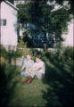
Mary and Page Stegner, New Mexico
1941; 1942; 1943; 1944; 1945; 1946; 1947
Image
uum_map
106
Mary and Wallace Stegner, New Mexico (?)
1940; 1941; 1942; 1943; 1944; 1945; 1946; 1947; 1948; 1949; 1950; 1951; 1952; 1953; 1954; 1955; 1956; 1957; 1958; 1959; 1960
Image
uum_map
107
Mary and Wallace Stegner, New Mexico (?)
1940; 1941; 1942; 1943; 1944; 1945; 1946; 1947; 1948; 1949; 1950; 1951; 1952; 1953; 1954; 1955; 1956; 1957; 1958; 1959; 1960
Image
uum_map
108
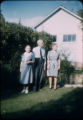
Mary Page Stegner and an unidentified elderly couple, New Mexico (?)
1941; 1942; 1943; 1944; 1945; 1946; 1947
Image
uum_map
109
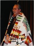
Mickey Ibarra at Albuquerque 1997
1997
Image
uum_map
110
Miscellaneous Schools p.5
1904
Image
dha_cp
111
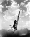
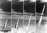
Missile Industry-Sperry Utah Sergeant P.6
Image
dha_cp
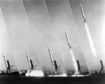
112
Missile Industry-Sperry Utah Sergeant P.8
Image
dha_cp
113
Missile Industry-Sperry Utah Sergeant P.9
Image
dha_cp
114
Monchiquite dike, looking south from Needle Peak, NM. Shaler, photo
1890; 1891; 1892; 1893; 1894; 1895; 1896; 1897; 1898; 1899; 1900; 1901; 1902; 1903; 1904; 1905
Image
uum_map
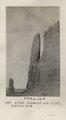
115
Monument and cliff, Todilto Park (Photo G384)
1913
Image
uum_map
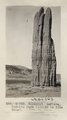
116
Monument, LaPlata, Todilto Park (III-20 is like this) (Photo G383)
1913
Image
uum_map
117
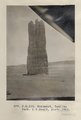
Monument, Todilto Park. K.C.Heald, photo. 1913 (Photo N-M133)
1913
Image
uum_map
118
Navajo Indians at Shiprock
1915
Image
uum_map
119
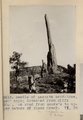
Needle of LaPlata sandstone, 150' high; detached from cliff 300'. On road from Moore's to upper waters of Black Creek. VI, 38 (Photo G213)
1911
Image
uum_map
120
Needle Peak (Shiprock) looking north 68° west from a distance of 1 1/2 mi. south of Shiprock, NM. Shaler, photo
1890; 1891; 1892; 1893; 1894; 1895; 1896; 1897; 1898; 1899; 1900; 1901; 1902; 1903; 1904; 1905
Image
uum_map
121
New Mexico
Image
uum_map
122
New Mexico P.1
Image
dha_cp
123
New Mexico desert
1941; 1942; 1943; 1944; 1945; 1946; 1947
Image
uum_map
124
New Mexico desert
1941; 1942; 1943; 1944; 1945; 1946; 1947
Image
uum_map
125
New Mexico, Cimmaron, grist mill
1945; 1946; 1947; 1948; 1949; 1950; 1951; 1952; 1953; 1954; 1955; 1956; 1957; 1958; 1959; 1960; 1961; 1962; 1963; 1964; 1965
Image
uum_map
101
-
125
of
210
<
1
2
3
4
5
6
7
8
9
>