| Title | Date | Type | Setname | ||
|---|---|---|---|---|---|
| 526 |  | Nevada, Pyramid Lake, | 1945; 1946; 1947; 1948; 1949; 1950; 1951; 1952; 1953; 1954; 1955; 1956; 1957; 1958; 1959; 1960; 1961; 1962; 1963; 1964; 1965 | Image | uum_map |
| 527 |  | Nevada, Pyramid Lake, | 1945; 1946; 1947; 1948; 1949; 1950; 1951; 1952; 1953; 1954; 1955; 1956; 1957; 1958; 1959; 1960; 1961; 1962; 1963; 1964; 1965 | Image | uum_map |
| 528 |  | Nevada, Pyramid Lake, | 1945; 1946; 1947; 1948; 1949; 1950; 1951; 1952; 1953; 1954; 1955; 1956; 1957; 1958; 1959; 1960; 1961; 1962; 1963; 1964; 1965 | Image | uum_map |
| 529 |  | Nevada, Pyramid Lake, | 1945; 1946; 1947; 1948; 1949; 1950; 1951; 1952; 1953; 1954; 1955; 1956; 1957; 1958; 1959; 1960; 1961; 1962; 1963; 1964; 1965 | Image | uum_map |
| 530 |  | Nevada, Pyramid Lake, | 1945; 1946; 1947; 1948; 1949; 1950; 1951; 1952; 1953; 1954; 1955; 1956; 1957; 1958; 1959; 1960; 1961; 1962; 1963; 1964; 1965 | Image | uum_map |
| 531 |  | Nevada, Pyramid Lake, | 1945; 1946; 1947; 1948; 1949; 1950; 1951; 1952; 1953; 1954; 1955; 1956; 1957; 1958; 1959; 1960; 1961; 1962; 1963; 1964; 1965 | Image | uum_map |
| 532 |  | Nevada, Pyramid Lake, | 1945; 1946; 1947; 1948; 1949; 1950; 1951; 1952; 1953; 1954; 1955; 1956; 1957; 1958; 1959; 1960; 1961; 1962; 1963; 1964; 1965 | Image | uum_map |
| 533 | 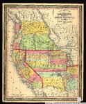 | New map of the state of California, the territories of Oregon, Washington, Utah & New Mexico. | 1853 | Image/StillImage | uu_awm |
| 534 |  | No Place To Pitch Their Teepees: Shoshone Adaptation To Mormon Settlers In Cache Valley, 1855-1870 | 1995 | Text | uaida_main |
| 535 |  | Note from James Fisher | Text | uaida_main | |
| 536 | | Notes on the History of the Southern Paiutes and Western Shoshonis | 1971 | Text | uaida_main |
| 537 |  | Nuclear test, Nevada | 1958-10 | Image/StillImage | uum_map |
| 538 |  | Oats Field, Wells, Nevada | 1910-08-23 | Image | dha_scp |
| 539 |  | Oats in Stacks, Wells, Nevada | 1910-08-23 | Image | dha_scp |
| 540 |  | Ophir Camp, Birds eye. Neco mining district - Nevada | 1908; 1909; 1910; 1911; 1912 | Image | uum_map |
| 541 |  | Oregon-California trip, 1921: Searchlight, Nevada, north of Needles, California | 1921-08-21 | Image/StillImage | uum_map |
| 542 |  | Osceola, Nevada [01] | 1940; 1941; 1942; 1943; 1944; 1945; 1946; 1947; 1948; 1949; 1950; 1951; 1952; 1953; 1954; 1955; 1956; 1957; 1958; 1959; 1960 | Image | uum_map |
| 543 |  | Osceola, Nevada [02] | 1940; 1941; 1942; 1943; 1944; 1945; 1946; 1947; 1948; 1949; 1950; 1951; 1952; 1953; 1954; 1955; 1956; 1957; 1958; 1959; 1960 | Image | uum_map |
| 544 |  | Outlet Tunnel, Bishop Creek, Wells, Nevada | 1910-08-23 | Image | dha_scp |
| 545 |  | Personal account of downwinders and nuclear weapons testing: Sara Penny | 2000; 2001; 2002; 2003; 2004; 2005; 2006; 2007; 2008; 2009; 2010; 2011; 2012; 2013; 2014; 2015; 2016 | Text | uum_dua |
| 546 |  | Pheasants, Nevada | 1945; 1946; 1947; 1948; 1949; 1950; 1951; 1952; 1953; 1954; 1955; 1956; 1957; 1958; 1959; 1960; 1961; 1962; 1963; 1964; 1965 | Image | uum_map |
| 547 |  | Photographic copy of List of Mining Districts; 1912-1914 | 1914 | Image | uum_map |
| 548 |  | Photographic copy of U.S. Geologic Survey Publication Geological Chart of the State of Nevada, with location of Ophir Mines drawn in | 1908; 1909; 1910; 1911; 1912 | Image | uum_map |
| 549 |  | Photographic copy of U.S. Geologic Survey Publication Geological Chart of the State of Nevada; Showing location of Fairview, Churchill County, Nevada | Image | uum_map | |
| 550 | 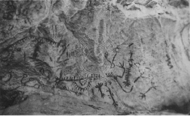 | Pictographs in Tunnel Canyon, Nevada. | Image/StillImage | uaida_main |