Home
Browse
Ask Us
Chat
Harmful Language Statement
Log in
Advanced Search
Year
1853
1854
1855
1856
1857
1858
1859
1860
1861
1862
1863
1864
1865
1866
1867
1868
1869
1870
1871
1872
1873
1874
1875
1876
1877
1878
1879
1880
1881
1882
1883
1884
1885
1886
1887
1888
1889
1890
1891
1892
1893
1894
1895
1896
1897
1898
1899
1900
1901
1902
1903
1904
1905
1906
1907
1908
1909
1910
1911
1912
1913
1914
1915
1916
1917
1918
1919
1920
1921
1922
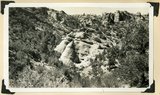
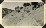
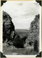
1923
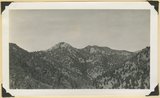
1924
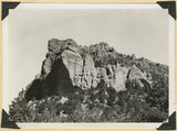
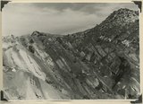
1925
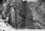
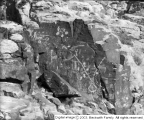
1926
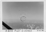
1927
1928
1929
1930
1931
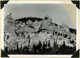
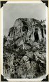
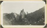
1932
1933
1934
1935
1936
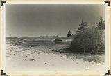
1937
1938
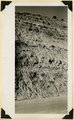
1939
1940
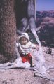
1941
1942
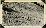
1943
1944
1945
1946
1947
1948
1949
1950
1951
1952
1953
1954
1955
1956
1957
1958
1959
1960
1961
1962
1963
1964
1965
1966
1967
1968
1969
1970
1971
1972
1973
1974
1975
1976
1977
1978
1979
1980
1981
1982
1983
1984
1985
1986
1987
1988
1989
1990
1991
1992
1993
1994
1995
1996
1997
1998
TO
1853
1854
1855
1856
1857
1858
1859
1860
1861
1862
1863
1864
1865
1866
1867
1868
1869
1870
1871
1872
1873
1874
1875
1876
1877
1878
1879
1880
1881
1882
1883
1884
1885
1886
1887
1888
1889
1890
1891
1892
1893
1894
1895
1896
1897
1898
1899
1900
1901
1902
1903
1904
1905
1906
1907
1908
1909
1910
1911
1912
1913
1914
1915
1916
1917
1918
1919
1920
1921
1922
1923
1924
1925
1926
1927
1928
1929
1930
1931
1932
1933
1934
1935
1936
1937
1938
1939
1940
1941
1942
1943
1944
1945
1946
1947
1948
1949
1950
1951
1952
1953
1954
1955
1956
1957
1958
1959
1960
1961
1962
1963
1964
1965
1966
1967
1968
1969
1970
1971
1972
1973
1974
1975
1976
1977
1978
1979
1980
1981
1982
1983
1984
1985
1986
1987
1988
1989
1990
1991
1992
1993
1994
1995
1996
1997
1998
Type
Image
210
Format
image/jpeg
210
Collection
Beckwith Photograph Collection
48
Photo Archives
154
Ski and Snow Sports Archives
4
Westminster College Photographs
4
Filters:
Spatial Coverage:
"Iron County (Utah)"
Type:
"Image"
Format:
image
76
-
100
of
210
<
1
2
3
4
5
6
7
8
9
>
Gallery view
Number of results to display per page
10
25
50
100
200
Sort by Relevance
Sort by Title A-Z
Sort by Title Z-A
Sort by Date Ascending
Sort by Date Descending
Sort by Last Modified Ascending
Sort by Last Modified Descending
Title
Date
Type
Setname
76
The Gospel Tent at Parowan
Image
wc_pc
77
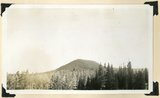
Hancock Peak. Volcanic cone, Iron County, UT, 1942
1942
Image
uum_map
78
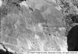
Human Footprints(?), The Gap
1929-10-12
Image
dc_bpc
79
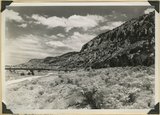
Hurricane Cliffs looking north across mouth of Swayne Creek. Iron County
1941; 1942
Image
uum_map
80
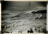
Hurricane Cliffs, formed by westward dipping Moenkopi strata involved in the Kanarra fold. Hurricane fault passes along the base and through the valley of Murie Creek (left); thick alluvium on the downthrown block (foreground). Iron County, UT, 1942
1942
Image
uum_map
81
Indian rock art
1939
Image
dc_bpc
82
Johnson covered this open-air test in Nevada for radio station KSUB of Cedar City, Utah.
1952-04-22
Image
uum_map
83
The Journey Hitherward
1929-10-12
Image
dc_bpc
84
Kaiparowits formation (Cretaceous) overlain by the Wasatch Tertiary. Bowery Canyon, Iron County, 1942
1942
Image
uum_map
85
Kaiparowits formation (Cretaceous) overlain by the Wasatch Tertiary. Bowery Canyon, Iron County, 1942
1942
Image
uum_map
86
Kaiparowits formation (Cretaceous) overlain by the Wasatch Tertiary. Bowery Canyon, Iron County, 1942
1942
Image
uum_map
87
Kaiparowits formation Cretaceous. Conglomerate (pinnacles) in contact with bedded arkosie sandstone. Parowan Canyon. Iron Co
1941
Image
uum_map
88
Kaiparowits formation near southwest corner of Cedar Breaks National Monument. Iron County, UT. 1941
1941
Image
uum_map
89
Kaiparowits formation on Cedar City, Cedar Breaks road above Wood's Ranch. Iron County, UT. 1941
1941
Image
uum_map
90
Kaiparowits formation unconformable below Wasatch limestone south, foot of Parowan Canyon, Iron County, UT. 1941
1941
Image
uum_map
91
Kaiparowits formation, head of Deep Creek, Iron County, UT. 1941
1941
Image
uum_map
92
Lake like no 2837, about a half mile down valley
1942
Image
uum_map
93
Lava cap on Straight Cliffs formation foot of dugway in Cedar Canyon. Iron County, UT
1937; 1938
Image
uum_map
94
Log Hollow fault (Cretaceous), Kaiparowits formation, on upthrown side (middle and right) in contact with Tertiary (left). Estimated displacement 700 feet. Bowery Canyon, Iron County, UT. 1942
1942
Image
uum_map
95
Man and Teepees
Image
dc_bpc
96
Mary Margaret in base of Bristlecone pine, Cedar Breaks
1966-07-04
Image
uum_map
97
Moenkopi beds upturned in the Kanarra fold and broken by a fault. Lawrence Canyon, Iron County, UT, 1942
1942
Image
uum_map
98
Moenkopi formation (Shnabkaib and upper red members), Shinarump conglomerate, and Chinle formation, all tilted steeply eastward (right). Gulch near the mouth of Coal Canyon, Iron County, UT, 1942
1942
Image
uum_map
99
Moenkopi formation, Shnabkaib and upper red members. Chinle (upper right), knob of Shinarump offset by faulting (center skyline). Near mouth of Coal Canyon. Iron County, UT, 1942
1942
Image
uum_map
100
Mouth of Camp Creek. Resistant limestones of lowest Triassic make walls. Iron County, UT. 1941
1941
Image
uum_map
76
-
100
of
210
<
1
2
3
4
5
6
7
8
9
>