Home
Browse
Ask Us
Chat
Harmful Language Statement
Log in
University of Utah Marriott Library
Advanced Search
Year
1990
1991
1992
1993
1994
1995
1996
1997
TO
1990
1991
1992
1993
1994
1995
1996
1997
Type
Image
10
Text
1
Format
image/jpeg
10
application/pdf
1
Collection
Photo Archives
10
Superfund Records Center Records
1
Filters:
Spatial Coverage:
"Great Salt Lake (Utah)"
1
-
25
of
11
Gallery view
Number of results to display per page
10
25
50
100
200
Sort by Relevance
Sort by Title A-Z
Sort by Title Z-A
Sort by Date Ascending
Sort by Date Descending
Sort by Last Modified Ascending
Sort by Last Modified Descending
Title
Date
Type
Setname
1
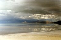
Aerial view of Great Salt Lake
1995-03-14
Image
uum_map
2
Great Salt Lake dikes
1995-03-14
Image
uum_map
3
Gun emplacements used as part of UTTR, Lakeside Mountains
1995-03-14
Image
uum_map
4
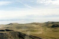
View looking north near Lakeside Mountains toward western Great Salt Lake
1995-03-14
Image
uum_map
5
View looking north near Lakeside Mountains toward western Great Salt Lake
1995-03-14
Image
uum_map
6
View looking north near Lakeside Mountains toward western Great Salt Lake; Pilot Peak in right background
1995-03-14
Image
uum_map
7
View over Lakeside Mountains, looking east toward Great Salt Lake, railroad causeway in middle distance
1995-03-14
Image
uum_map
8
View over Lakeside Mountains, looking east toward Great Salt Lake, railroad causeway in middle distance
1995-03-14
Image
uum_map
9
View over Lakeside Mountains, looking east toward Great Salt Lake, railroad causeway in middle distance
1995-03-14
Image
uum_map
10
View over Lakeside Mountains, looking southeast toward Great Salt Lake, Gunnison Island in middle distance
1995-03-14
Image
uum_map
11
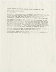
Correspondence and documentation for public meetings, workshops, and task force meetings on Kennecott Superfund sites, 1990-1997
1990; 1991; 1995; 1996; 1997
Text
uum_srcr
1
-
25
of
11