|
|
Title | Date | Type | Setname |
| 26 |
 |
Arches National Park. | 1966 | Image | uum_map |
| 27 |
 |
Arches National Park. | 1966 | Image | uum_map |
| 28 |
 |
Arches National Park. | 1966 | Image | uum_map |
| 29 |
 |
Arches National Park. | 1966 | Image | uum_map |
| 30 |
 |
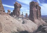
Arches National Park: Hoodoo | 1940; 1941; 1942; 1943; 1944; 1945; 1946; 1947; 1948; 1949; 1950; 1951; 1952; 1953; 1954; 1955; 1956; 1957; 1958; 1959 | Image | uum_map |
| 31 |
 |
Arches National Park: Parade of Elephants | 1940; 1941; 1942; 1943; 1944; 1945; 1946; 1947; 1948; 1949; 1950; 1951; 1952; 1953; 1954; 1955; 1956; 1957; 1958; 1959 | Image | uum_map |
| 32 |
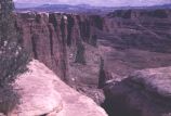 |
Arches National Park? | 1937; 1938; 1939; 1940; 1941; 1942; 1943; 1944; 1945; 1946; 1947; 1948; 1949; 1950; 1951; 1952; 1953; 1954; 1955; 1956; 1957; 1958; 1959; 1960; 1961; 1962; 1963; 1964; 1965; 1966; 1967; 1968; 1969; 1970; 1971; 1972; 1973; 1974; 1975; 1976; 1977; 1978; 1979; 1980 | Image | uum_map_rr |
| 33 |
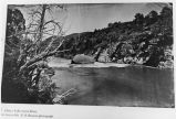 |
Ashley Falls, Green River | 1871 | Image | uum_map_rr |
| 34 |
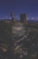 |
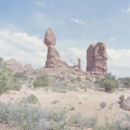
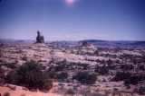
Balanced Rock and snow-covered La Sal Mountains in distance | 1960-10-12 | Image | uum_map |
| 35 |
 |
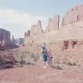
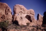
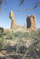
Balanced Rock area, Arches National Park [1] | 1937; 1938; 1939; 1940; 1941; 1942; 1943; 1944; 1945; 1946; 1947; 1948; 1949; 1950; 1951; 1952; 1953; 1954; 1955; 1956; 1957; 1958; 1959; 1960; 1961; 1962; 1963; 1964; 1965; 1966; 1967; 1968; 1969; 1970; 1971; 1972; 1973; 1974; 1975; 1976; 1977; 1978; 1979; 1980 | Image | uum_map_rr |
| 36 |
 |
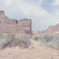
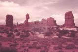
Balanced Rock area, Arches National Park [2] | 1937; 1938; 1939; 1940; 1941; 1942; 1943; 1944; 1945; 1946; 1947; 1948; 1949; 1950; 1951; 1952; 1953; 1954; 1955; 1956; 1957; 1958; 1959; 1960; 1961; 1962; 1963; 1964; 1965; 1966; 1967; 1968; 1969; 1970; 1971; 1972; 1973; 1974; 1975; 1976; 1977; 1978; 1979; 1980 | Image | uum_map_rr |
| 37 |
 |
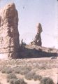
Balanced Rock area, Arches National Park [3] | 1937; 1938; 1939; 1940; 1941; 1942; 1943; 1944; 1945; 1946; 1947; 1948; 1949; 1950; 1951; 1952; 1953; 1954; 1955; 1956; 1957; 1958; 1959; 1960; 1961; 1962; 1963; 1964; 1965; 1966; 1967; 1968; 1969; 1970; 1971; 1972; 1973; 1974; 1975; 1976; 1977; 1978; 1979; 1980 | Image | uum_map_rr |
| 38 |
 |
Balanced Rock area, Arches National Park [4] | 1937; 1938; 1939; 1940; 1941; 1942; 1943; 1944; 1945; 1946; 1947; 1948; 1949; 1950; 1951; 1952; 1953; 1954; 1955; 1956; 1957; 1958; 1959; 1960; 1961; 1962; 1963; 1964; 1965; 1966; 1967; 1968; 1969; 1970; 1971; 1972; 1973; 1974; 1975; 1976; 1977; 1978; 1979; 1980 | Image | uum_map_rr |
| 39 |
 |
Balanced Rock area, Arches National Park [5] | 1937; 1938; 1939; 1940; 1941; 1942; 1943; 1944; 1945; 1946; 1947; 1948; 1949; 1950; 1951; 1952; 1953; 1954; 1955; 1956; 1957; 1958; 1959; 1960; 1961; 1962; 1963; 1964; 1965; 1966; 1967; 1968; 1969; 1970; 1971; 1972; 1973; 1974; 1975; 1976; 1977; 1978; 1979; 1980 | Image | uum_map_rr |
| 40 |
 |
Barge or stern-wheel craft used by the Moab Garage Co. on the Colorado River during the 1920s to haul freight or passengers. Photo taken near Moab, Utah | 1920; 1921; 1922; 1923; 1924; 1925; 1926; 1927; 1928; 1929; 1930 | Image | uum_map_rr |
| 41 |
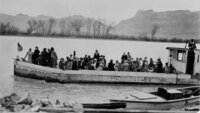 |
Barge or stern-wheel craft used by the Moab Garage Co. on the Colorado River during the 1920s to haul freight or passengers. Photo taken near Moab, Utah | 1920; 1921; 1922; 1923; 1924; 1925; 1926; 1927; 1928; 1929; 1930 | Image | uum_map_rr |
| 42 |
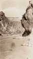 |
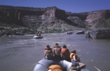
Below a rapid in Westwater Canyon | 1933 | Image | uum_map_rr |
| 43 |
 |
Below the Little Hole in Westwater Canyon | 1933 | Image | uum_map_rr |
| 44 |
 |
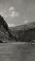
Below Westwater [canyon], Colorado River | 1970-06 | Image | uum_map_rr |
| 45 |
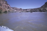 |
Below Westwater [canyon], Colorado River | 1970-06 | Image | uum_map_rr |
| 46 |
 |
Below Westwater [canyon], Colorado River | 1970-06 | Image | uum_map_rr |
| 47 |
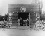 |
Blacksmith shop (exterior) | 1900; 1901; 1902; 1903; 1904; 1905; 1906; 1907; 1908; 1909; 1910; 1911; 1912; 1913; 1914; 1915; 1916; 1917; 1918; 1919; 1920 | Image | uum_map_rr |
| 48 |
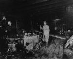 |
Blacksmith's shop (interior) | 1900; 1901; 1902; 1903; 1904; 1905; 1906; 1907; 1908; 1909; 1910; 1911; 1912; 1913; 1914; 1915; 1916; 1917; 1918; 1919; 1920 | Image | uum_map_rr |
| 49 |
 |
Bluff on the Moab road about 43 miles north of Monticello, Utah, showing LaPlata sandstone and McElmo formation. The upper La plata is about 200 feet thick and the lower La plata, the top of which is seen here, is about 300 feet, these sandstones are separated by red, shaly crinkled material. Lee, 1925. | 1925 | Image | uum_map |
| 50 |
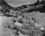 |
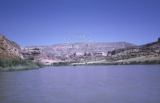
Boaters on the Colorado River near Moab | 1959 | Image | uum_map |