Home
Browse
Ask Us
Chat
Harmful Language Statement
Log in
Advanced Search
Year
1826
1827
1828
1829
1830
1831
1832
1833
1834
1835
1836
1837
1838
1839
1840
1841
1842
1843
1844
1845
1846
1847
1848
1849
1850
1851
1852
1853
1854
1855
1856
1857
1858
1859
1860
1861
1862
1863
1864
1865
1866
1867
1868
1869
1870
1871
1872
1873
1874
1875
1876
1877
1878
1879
1880
1881
1882
1883
1884
1885
1886
1887
1888
1889
1890
1891
1892
1893
1894
1895
1896
1897
1898
1899
1900
1901
1902
1903
1904
1905
1906
1907
1908
1909
1910
1911
1912
1913
1914
1915
1916
1917
1918
1919
1920
1921
1922
1923
1924
1925
1926
1927
1928
1929
1930
1931
1932
1933
1934
1935
1936
1937
1938
1939
1940
1941
1942
1943
1944
1945
1946
1947
1948
1949
1950
1951
1952
1953
1954
1955
1956
1957
1958
1959
1960
1961
1962
1963
1964
1965
1966
1967
1968
1969
1970
1971
1972
1973
1974
1975
1976
1977
1978
1979
1980
1981
1982
1983
1984
1985
1986
1987
1988
1989
1990
1991
1992
1993
1994
1995
1996
1997
1998
1999
2000
2001
2002
2003
2004
2005
2006
2007
2008
2009
2010
2011
2012
2013
2014
2015
2016
2017
2018
2019
2020
2021
2022
2023
TO
1826
1827
1828
1829
1830
1831
1832
1833
1834
1835
1836
1837
1838
1839
1840
1841
1842
1843
1844
1845
1846
1847
1848
1849
1850
1851
1852
1853
1854
1855
1856
1857
1858
1859
1860
1861
1862
1863
1864
1865
1866
1867
1868
1869
1870
1871
1872
1873
1874
1875
1876
1877
1878
1879
1880
1881
1882
1883
1884
1885
1886
1887
1888
1889
1890
1891
1892
1893
1894
1895
1896
1897
1898
1899
1900
1901
1902
1903
1904
1905
1906
1907
1908
1909
1910
1911
1912
1913
1914
1915
1916
1917
1918
1919
1920
1921
1922
1923
1924
1925
1926
1927
1928
1929
1930
1931
1932
1933
1934
1935
1936
1937
1938
1939
1940
1941
1942
1943
1944
1945
1946
1947
1948
1949
1950
1951
1952
1953
1954
1955
1956
1957
1958
1959
1960
1961
1962
1963
1964
1965
1966
1967
1968
1969
1970
1971
1972
1973
1974
1975
1976
1977
1978
1979
1980
1981
1982
1983
1984
1985
1986
1987
1988
1989
1990
1991
1992
1993
1994
1995
1996
1997
1998
1999
2000
2001
2002
2003
2004
2005
2006
2007
2008
2009
2010
2011
2012
2013
2014
2015
2016
2017
2018
2019
2020
2021
2022
2023
Type
Image
1,343
Image/StillImage
1,293
Text
308
Sound
59
Format
image/jpeg
2,366
application/pdf
424
audio/mpeg
40
video/mp4
19
Collection
Al W. Morton Collection, 1930s-1950s
5
Alta Avalanche
2
American Westward Migration
1
Chieko N Okazaki papers
2
Classified Photographs
209
Colorado Riverbed Case
12
David Oman McKay Papers
1
John Hamilton Morgan Papers
43
Land Use - Transportation Scenario Pl...
1
Marriner S. Eccles Papers
1
Photo Archives
566
Regional History Center
40
Shipler Commercial Photographers
40
Ski and Snow Sports Photo Archives
678
Taylor A. Woolley Papers
2
Thorne Photographs
4
UAIDA Main Collection
534
Uintah County Regional History Center...
26
Utah Humanities Research Foundation
1
Utah Quilt Heritage Records
4
Utah River Running Photo Archives
819
Vernal Express Photographs
2
Western Soundscape
59
Western Waters Electronic Resources
68
William Edward Hook Glass Negatives
70
More
Filters:
Spatial Coverage:
"Colorado"
Year End:
2016
1776
-
1800
of
3,190
<
67
68
69
70
71
72
73
74
75
76
>
Gallery view
Number of results to display per page
10
25
50
100
200
Sort by Relevance
Sort by Title A-Z
Sort by Title Z-A
Sort by Date Ascending
Sort by Date Descending
Sort by Last Modified Ascending
Sort by Last Modified Descending
Title
Date
Type
Setname
1776
Map of Ute Reservation in Western Colorado, and Lands Ceded Over Time
1882
Image/StillImage
uaida_main
1777
Map showing the boundary of the Shoshone Indian territory
1941
Image/StillImage
uaida_main
1778
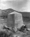
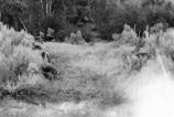
Marker on spot of Thornburgh Battle ground, monument, Sept 24 to Oct. 5 - 1879
1927; 1928; 1929; 1930; 1931; 1932; 1933; 1934; 1935; 1936; 1937; 1938; 1939; 1940
Image/StillImage
uaida_main
1779
Marriner S. Eccles, general correspondence, 1951 - 1977: S
1951; 1952; 1954; 1955; 1958; 1959; 1961; 1962; 1966; 1968; 1969; 1972; 1977
Text
uum_msep
1780
Marshall Pass and Mt. Cochetopa, Colorado
1883
Image/StillImage
uum_map
1781
Marshall Pass, Colorado
1883
Image/StillImage
uum_map
1782
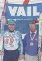
Marvin Melville and Gene Timmons at Vail, CO, 1991.
1991
Image
uum_map_usa
1783
Marvin Melville holding skis and wearing various medals.
1991
Image
uum_map_usa
1784
Marvin Melville skiing [02]
1953; 1954; 1955; 1956; 1957; 1958; 1959; 1960
Image/StillImage
uum_map_usa
1785
Maybell (Planimetric) NW-8 (US DOI BLM) 1974
1974
Image/StillImage
ucl_maps
1786
Mayor Will Nicholson presenting award at a Military Police ceremony, Colorado State Capitol, Denver
1955
Image
uum_map
1787
McCook, Little Jim, Pawnee and others [X-30549]
1910; 1911; 1912; 1913; 1914; 1915; 1916; 1917; 1918; 1919; 1920
Image/StillImage
uaida_main
1788
McCook, Little Jim, Pawnee, and others [X-30548]
1910; 1911; 1912; 1913; 1914; 1915; 1916; 1917; 1918; 1919; 1920
Image/StillImage
uaida_main
1789
McElmo Canyon near its western extremity, showing McElmo formations on LaPlata sandstone
1925
Image
uum_map
1790
McElmo Canyon, Colo., showing lower part of Wingate sandstone, 1925
1925
Image
uum_map
1791
McElmo strata, Holly's ranch, McElmo valley, Colorado, 33± miles west of Cortez, Colorado. 1910 (Photo G-125)
1910
Image
uum_map
1792
McElmo strata, Holly's ranche, McElmo valley, Colo., 33+ mi. west of Cortez, Colo., 1910 (Photo G-125)
1910
Image
uum_map
1793
McElmo strata, Holly's ranche, McElmo valley, Colo., 33+ mi. west of Cortez, Colo., 1910 (Photo G-126)
1910
Image
uum_map
1794
McElmo strata, Holly's ranche, McElmo valley, Colo., 33+ mi. west of Cortez, Colo., 1910 (Photo N-M76)
1910
Image
uum_map
1795
Meeker Massacre P.1
1948
Image
dha_cp
1796
Meeker Massacre P.2
1948
Image
dha_cp
1797
Meeker Massacre P.3
1948
Image
dha_cp
1798
Meeker Massacre P.4
1948
Image
dha_cp
1799
Meeker Massacre P.5
1948
Image
dha_cp
1800
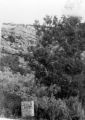
Meeker Massacre-Marker P.1
1978
Image
dha_cp
1776
-
1800
of
3,190
<
67
68
69
70
71
72
73
74
75
76
>