| Title | Date | Type | Setname | ||
|---|---|---|---|---|---|
| 1101 |
 | Man and woman resting during a trip down the Yampa River. | 1951-06 | Image | uum_map |
| 1102 |
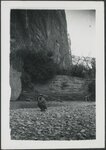 | Man crouched by a creek | 1940; 1941 | uum_map_rr | |
| 1103 |
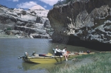
 | Man smoking while boating down the Yampa River. | 1956 | Image | uum_map |
| 1104 |
 | Manassa, Colorado. Apple trees | 1880; 1881; 1882; 1883; 1884; 1885 | uum_map | |
| 1105 |
 | Manassa, Colorado. Box Elder trees planted by John Morgan | 1880; 1881; 1882; 1883; 1884; 1885 | uum_map | |
| 1106 |
 | Manassa, Colorado. Field | 1880; 1881; 1882; 1883; 1884; 1885 | uum_map | |
| 1107 |
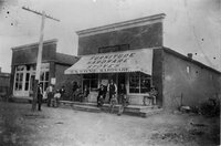 | Manassa, Colorado. Haynie Hardware Store | 1900; 1901; 1902; 1903; 1904; 1905; 1906; 1907; 1908; 1909; 1910; 1911; 1912; 1913; 1914; 1915; 1916; 1917; 1918; 1919; 1920; 1921; 1922; 1923; 1924; 1925; 1926; 1927; 1928; 1929; 1930 | uum_map | |
| 1108 |
 | Manassa, Colorado. Home of Moses Thatcher | 1880; 1881; 1882; 1883; 1884; 1885 | uum_map | |
| 1109 |
 | Manassa, Colorado. Miller Ranch home | 1880; 1881; 1882; 1883; 1884; 1885 | uum_map | |
| 1110 |
 | Manassa, Colorado. Ranch to the east of Manassa. | 1880; 1881; 1882; 1883; 1884; 1885 | uum_map | |
| 1111 |
 | Manassa, Colorado. Sila Smith home | 1940; 1941; 1942; 1943; 1944; 1945; 1946; 1947; 1948; 1949; 1950 | uum_map | |
| 1112 |
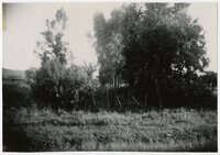
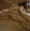 | Mantle Cave | 1950; 1951; 1952; 1953; 1954; 1955; 1956; 1957; 1958; 1959; 1960; 1961; 1962; 1963; 1964; 1965; 1966; 1967; 1968; 1969; 1970; 1971; 1972; 1973; 1974; 1975; 1976; 1977; 1978; 1979; 1980; 1981; 1982; 1983; 1984; 1985; 1986; 1987; 1988; 1989 | Image | uum_map_rr |
| 1113 |
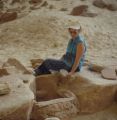 | Mantle Cave | 1950; 1951; 1952; 1953; 1954; 1955; 1956; 1957; 1958; 1959; 1960; 1961; 1962; 1963; 1964; 1965; 1966; 1967; 1968; 1969; 1970; 1971; 1972; 1973; 1974; 1975; 1976; 1977; 1978; 1979; 1980; 1981; 1982; 1983; 1984; 1985; 1986; 1987; 1988; 1989 | Image | uum_map_rr |
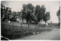
| 1114 |
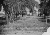
 | Mantle Ranch | 1966-07 | Image | uum_map_rr |
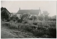
| 1115 |
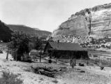 | Mantle Ranch P.2 | 1955-07 | Image | dha_cp |
| 1116 |
 | Map of Shoshone, Goshute, Bannock, Wind River and Panamint Indian Tribal Groups | 1957 | Image/StillImage | uaida_main |
| 1117 |
 | Map of Ute Reservation in Western Colorado, and Lands Ceded Over Time | 1882 | Image/StillImage | uaida_main |
| 1118 |
 | Map showing the boundary of the Shoshone Indian territory | 1941 | Image/StillImage | uaida_main |
| 1119 |
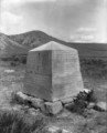 | Marker on spot of Thornburgh Battle ground, monument, Sept 24 to Oct. 5 - 1879 | 1927; 1928; 1929; 1930; 1931; 1932; 1933; 1934; 1935; 1936; 1937; 1938; 1939; 1940 | Image/StillImage | uaida_main |
| 1120 |
 | Marriner S. Eccles, general correspondence, 1951 - 1977: S | 1951; 1952; 1954; 1955; 1958; 1959; 1961; 1962; 1966; 1968; 1969; 1972; 1977 | Text | uum_msep |
| 1121 |
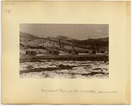 | Marshall Pass and Mt. Cochetopa, Colorado | 1883 | Image/StillImage | uum_map |
| 1122 |
 | Marshall Pass, Colorado | 1883 | Image/StillImage | uum_map |
| 1123 |
 | Marvin Melville skiing [02] | 1953; 1954; 1955; 1956; 1957; 1958; 1959; 1960 | Image/StillImage | uum_map_usa |
| 1124 |
 | Mayor Will Nicholson presenting award at a Military Police ceremony, Colorado State Capitol, Denver | 1955 | Image | uum_map |
| 1125 |
 | McCook, Little Jim, Pawnee and others [X-30549] | 1910; 1911; 1912; 1913; 1914; 1915; 1916; 1917; 1918; 1919; 1920 | Image/StillImage | uaida_main |