Home
Browse
Ask Us
Chat
Harmful Language Statement
Log in
Advanced Search
Year
1860
1861
1862
1863
1864
1865
1866
1867
1868
1869
1870
1871
1872
1873
1874
1875
1876
1877
1878
1879
1880
1881
1882
1883
1884
1885
1886
1887
1888
1889
1890
1891
1892
1893
1894
1895
1896
1897
1898
1899
1900
1901
1902
1903
1904
1905
1906
1907
1908
1909
1910
1911
1912
1913
1914
1915
1916
1917
1918
1919
1920
1921
1922
1923
1924
1925
1926
1927
1928
1929
1930
1931
1932
1933
1934
1935
1936
1937
1938
1939
1940
1941
1942
1943
1944
1945
1946
1947
1948
1949
1950
1951
1952
1953
1954
1955
1956
1957
1958
1959
1960
1961
1962
1963
1964
1965
1966
1967
1968
1969
1970
1971
1972
1973
1974
1975
1976
1977
1978
1979
1980
1981
1982
1983
1984
1985
1986
1987
1988
1989
1990
1991
1992
1993
1994
1995
1996
1997
1998
1999
2000
2001
2002
2003
2004
2005
2006
2007
2008
2009
2010
2011
2012
2013
2014
2015
2016
2017
2018
2019
2020
2021
2022
2023
TO
1860
1861
1862
1863
1864
1865
1866
1867
1868
1869
1870
1871
1872
1873
1874
1875
1876
1877
1878
1879
1880
1881
1882
1883
1884
1885
1886
1887
1888
1889
1890
1891
1892
1893
1894
1895
1896
1897
1898
1899
1900
1901
1902
1903
1904
1905
1906
1907
1908
1909
1910
1911
1912
1913
1914
1915
1916
1917
1918
1919
1920
1921
1922
1923
1924
1925
1926
1927
1928
1929
1930
1931
1932
1933
1934
1935
1936
1937
1938
1939
1940
1941
1942
1943
1944
1945
1946
1947
1948
1949
1950
1951
1952
1953
1954
1955
1956
1957
1958
1959
1960
1961
1962
1963
1964
1965
1966
1967
1968
1969
1970
1971
1972
1973
1974
1975
1976
1977
1978
1979
1980
1981
1982
1983
1984
1985
1986
1987
1988
1989
1990
1991
1992
1993
1994
1995
1996
1997
1998
1999
2000
2001
2002
2003
2004
2005
2006
2007
2008
2009
2010
2011
2012
2013
2014
2015
2016
2017
2018
2019
2020
2021
2022
2023
Type
Image
1,371
Image/StillImage
1,015
Text
8
Format
image/jpeg
2,917
Collection
Al W. Morton Collection, 1930s-1950s
5
Classified Photographs
267
Photo Archives
503
Regional History Center
45
Shipler Commercial Photographers
40
Ski and Snow Sports Photo Archives
785
Taylor A. Woolley Papers
2
Thorne Photographs
5
UAIDA Main Collection
30
Uintah County Regional History Center...
34
Utah River Running Photo Archives
791
Vernal Express Photographs
3
Vertebrate Zoology Voucher Images
337
William Edward Hook Glass Negatives
70
More
Filters:
Spatial Coverage:
"Colorado"
Format:
image
1126
-
1150
of
2,917
<
41
42
43
44
45
46
47
48
49
50
>
Gallery view
Number of results to display per page
10
25
50
100
200
Sort by Relevance
Sort by Title A-Z
Sort by Title Z-A
Sort by Date Ascending
Sort by Date Descending
Sort by Last Modified Ascending
Sort by Last Modified Descending
Title
Date
Type
Setname
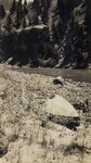
1126
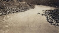
Glenwood Canyon - Bad riffle below Glenwood Springs.
1933
Image
uum_map_rr
1127
Glenwood Canyon - Below Clifton- 5 mi. above Gr[and] Jct. [Junction]
1933
Image
uum_map_rr
1128
Glenwood Canyon - Cottonwood Falls, Glenwood Canyon. River drops 100 feet to [a] mile. Portaged 2½ miles.
1933
Image
uum_map_rr
1129
Glenwood Canyon - Glenwood Springs, Colo. U.S.G.S. stream gauging station [on] r[ight].
1933
Image
uum_map_rr
1130
Glenwood Canyon - Repairing ribs of the kayak after being smashed in by waves-below Glenwood Springs, Colo.
1933
Image
uum_map_rr
1131
Glenwood Canyon - Spillway at power plant in Glenwood Canyon. Put boat in here after 2½ mile carry from dam headgate around falls.
1933
Image
uum_map_rr
1132
Glenwood Canyon - The Book Cliffs between Glenwood Springs and Grand Junction, Colo. The river here is exactly one mile above sea level.
1933
Image
uum_map_rr
1133
Glenwood Canyon - The Grand Mesa-near Clifton. Camped on oippostie shore night of Aug. 2.
1933
Image
uum_map_rr
1134
Gold Mining P.1
Image
dha_cp
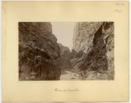
1135
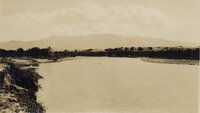
Gore Canyon
1933
Image
uum_map_rr
1136
Gore Canyon - "Rob Roy" in dry dock at Azure Camp. Making repairs after the heavy water & rocks of Gore Canyon.
1933
Image
uum_map_rr
1137
Gore Canyon - [near Blue River]
1933
Image
uum_map_rr
1138
Gore Canyon - [near Blue River]
1933
Image
uum_map_rr
1139
Gore Canyon - Bad fall in Gore Canyon. Portaged 50 feet around this.
1933
Image
uum_map_rr
1140
Gore Canyon - Blue River entering Colo. at Kremmling [Colorado]. River backed up by rocks at head of Gore Canyon, 6 mi. downstream.
1933
Image
uum_map_rr
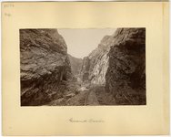
1141
Gore Canyon - Looking into Gore Canyon, near Kremmling [Colorado].
1933
Image
uum_map_rr
1142
Gore Canyon - Section of easy riffle near head of Gore Canyon.
1933
Image
uum_map_rr
1143
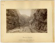
Grand Canyon of the Arkansas River, Colorado
1883
Image/StillImage
uum_map
1144
Grand Canyon of the Arkansas River, Colorado
1883
Image/StillImage
uum_map
1145
Grand Canyon of the Arkansas River, Colorado
1883
Image/StillImage
uum_map
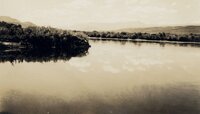
1146
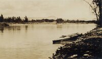
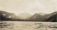
Grand Lake
1933
Image
uum_map_rr
1147
Grand Lake
1933
Image
uum_map_rr
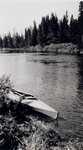
1148
Grand Lake - 2 mi. below Grand Lake
1933
Image
uum_map_rr
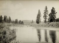
1149
Grand Lake - [Colorado River above Granby, Colorado]
1933
Image
uum_map_rr
1150
Grand Lake - [Colorado River at Grand Lake outlet]
1933
Image
uum_map_rr
1126
-
1150
of
2,917
<
41
42
43
44
45
46
47
48
49
50
>