| Title | Date | Type | Setname | ||
|---|---|---|---|---|---|
| 526 |
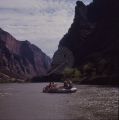
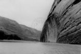
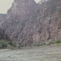 | Gates of Lodore | 1976 | Image | uum_map_rr |
| 527 |
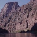 | Gates of Lodore | 1976 | Image | uum_map_rr |
| 528 |
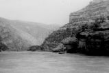
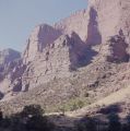 | Gates of Lodore | 1976 | Image | uum_map_rr |
| 529 |
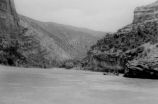
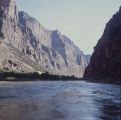 | Gates of Lodore | 1976 | Image | uum_map_rr |
| 530 |
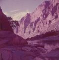
 | Gates of Lodore | 1976 | Image | uum_map_rr |
| 531 |
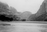
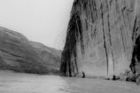
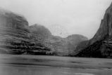 | Gates of Lodore | 1920; 1921; 1922; 1923; 1924; 1925; 1926; 1927; 1928; 1929; 1930; 1931; 1932; 1933; 1934; 1935; 1936; 1937; 1938; 1939; 1940; 1941; 1942; 1943; 1944; 1945; 1946; 1947; 1948; 1949 | Image | uum_map_rr |
| 532 |
 | Gates of Lodore | 1920; 1921; 1922; 1923; 1924; 1925; 1926; 1927; 1928; 1929; 1930; 1931; 1932; 1933; 1934; 1935; 1936; 1937; 1938; 1939; 1940; 1941; 1942; 1943; 1944; 1945; 1946; 1947; 1948; 1949 | Image | uum_map_rr |
| 533 |
 | Gates of Lodore | 1920; 1921; 1922; 1923; 1924; 1925; 1926; 1927; 1928; 1929; 1930; 1931; 1932; 1933; 1934; 1935; 1936; 1937; 1938; 1939; 1940; 1941; 1942; 1943; 1944; 1945; 1946; 1947; 1948; 1949 | Image | uum_map_rr |
| 534 |
 | Gates of Lodore | 1920; 1921; 1922; 1923; 1924; 1925; 1926; 1927; 1928; 1929; 1930; 1931; 1932; 1933; 1934; 1935; 1936; 1937; 1938; 1939; 1940; 1941; 1942; 1943; 1944; 1945; 1946; 1947; 1948; 1949 | Image | uum_map_rr |
| 535 |
 | Gates of Lodore | 1920; 1921; 1922; 1923; 1924; 1925; 1926; 1927; 1928; 1929; 1930; 1931; 1932; 1933; 1934; 1935; 1936; 1937; 1938; 1939; 1940; 1941; 1942; 1943; 1944; 1945; 1946; 1947; 1948; 1949 | Image | uum_map_rr |
| 536 |
 | Gates of Lodore | 1920; 1921; 1922; 1923; 1924; 1925; 1926; 1927; 1928; 1929; 1930; 1931; 1932; 1933; 1934; 1935; 1936; 1937; 1938; 1939; 1940; 1941; 1942; 1943; 1944; 1945; 1946; 1947; 1948; 1949 | Image | uum_map_rr |
| 537 |
 | Gates of Lodore (unmounted) | 1976 | Image | uum_map_rr |
| 538 |
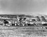
 | Gilsonite Mines and Mining - "Mack, Colo. - Rod Francke, Tom Davis, C.J. Neal - Gilsonite Storage Area" | 1920; 1921; 1922; 1923; 1924; 1925; 1926; 1927; 1928; 1929; 1930; 1931; 1932; 1933; 1934; 1935; 1936; 1937; 1938; 1939; 1940 | Image | uum_map |
| 539 |
 | Gilsonite Plant | Image | ucl_vep | |
| 540 |
 | Glenwood Canyon | 1933 | Image | uum_map_rr |
| 541 |
 | Glenwood Canyon - "Rob Roy" dismantled for repairs 6 mi. below Glenwood Sp[rings] after smashing bow frame in rapids. | 1933 | Image | uum_map_rr |
| 542 |
 | Glenwood Canyon - [Leaving Glenwood Springs] | 1933 | Image | uum_map_rr |
| 543 |
 | Glenwood Canyon - A nasty fall in Glenwood canyon- 1 mile below power plant, nearly swamped. | 1933 | Image | uum_map_rr |
| 544 |
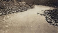 | Glenwood Canyon - Bad riffle below Glenwood Springs. | 1933 | Image | uum_map_rr |
| 545 |
 | Glenwood Canyon - Below Clifton- 5 mi. above Gr[and] Jct. [Junction] | 1933 | Image | uum_map_rr |
| 546 |
 | Glenwood Canyon - Cottonwood Falls, Glenwood Canyon. River drops 100 feet to [a] mile. Portaged 2½ miles. | 1933 | Image | uum_map_rr |
| 547 |
 | Glenwood Canyon - Glenwood Springs, Colo. U.S.G.S. stream gauging station [on] r[ight]. | 1933 | Image | uum_map_rr |
| 548 |
 | Glenwood Canyon - Repairing ribs of the kayak after being smashed in by waves-below Glenwood Springs, Colo. | 1933 | Image | uum_map_rr |
| 549 |
 | Glenwood Canyon - Spillway at power plant in Glenwood Canyon. Put boat in here after 2½ mile carry from dam headgate around falls. | 1933 | Image | uum_map_rr |
| 550 |
 | Glenwood Canyon - The Book Cliffs between Glenwood Springs and Grand Junction, Colo. The river here is exactly one mile above sea level. | 1933 | Image | uum_map_rr |