Home
Browse
Ask Us
Chat
Harmful Language Statement
Log in
Advanced Search
Year
1925
1926
1927
1928
1929
1930
1931
1932
1933
1934
1935
1936
1937
1938
1939
1940
1941
1942
1943
1944
1945
1946
1947
1948
1949
1950
1951
1952
1953
1954
1955
1956
1957
1958
1959
1960
1961
1962
1963
1964
1965
1966
1967
1968
1969
1970
1971
1972
1973
1974
1975
1976
1977
1978
1979
1980
1981
1982
1983
1984
1985
1986
1987
1988
1989
1990
1991
1992
1993
1994
1995
1996
1997
1998
1999
2000
2001
2002
2003
2004
2005
2006
2007
2008
2009
2010
TO
1925
1926
1927
1928
1929
1930
1931
1932
1933
1934
1935
1936
1937
1938
1939
1940
1941
1942
1943
1944
1945
1946
1947
1948
1949
1950
1951
1952
1953
1954
1955
1956
1957
1958
1959
1960
1961
1962
1963
1964
1965
1966
1967
1968
1969
1970
1971
1972
1973
1974
1975
1976
1977
1978
1979
1980
1981
1982
1983
1984
1985
1986
1987
1988
1989
1990
1991
1992
1993
1994
1995
1996
1997
1998
1999
2000
2001
2002
2003
2004
2005
2006
2007
2008
2009
2010
Type
Image
47
Image/StillImage
28
Sound
5
Format
image/jpeg
76
application/pdf
6
audio/mpeg
5
Collection
Beckwith Photograph Collection
1
Photo Archives
1
Ski and Snow Sports Archives
20
Utah River Running Photo Archives
60
Western Soundscape
5
Filters:
Spatial Coverage:
"Canyonlands National Park (Utah)"
26
-
50
of
87
<
1
2
3
4
>
Gallery view
Number of results to display per page
10
25
50
100
200
Sort by Relevance
Sort by Title A-Z
Sort by Title Z-A
Sort by Date Ascending
Sort by Date Descending
Sort by Last Modified Ascending
Sort by Last Modified Descending
Title
Date
Type
Setname
26
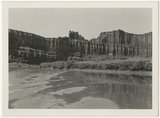
Labyrinth Canyon, approach to Cataract Canyon.
1969-04
Image
uum_map_rr
27
Labyrinth Canyon, approach to Cataract Canyon.
1969-04
Image
uum_map_rr
28
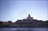
Butte of the Cross, Labyrinth.
1955
uum_map_rr
29
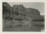
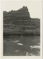
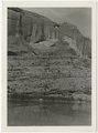
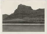
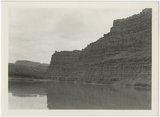
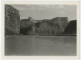
Norman D. Nevills' September 29-October 2, 1938 expedition for Philip W. Tompkins on the Colorado River from Moab down to near the mouth of the Green River. View of Colorado River and Orange Cliff Canyon.
1938-09-29; 1938-09-30; 1938-10-01; 1938-10-02
Image
uum_map_rr
30
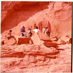
Holy Ghost petroglyphs, Horseshoe Canyon, Utah
1994; 1995; 1996; 1997
Image/StillImage
uum_map_rr
31
Cathedral Arch, Arch Canyon
1935; 1936; 1937; 1938; 1939; 1940; 1941; 1942; 1943; 1944; 1945; 1946; 1947; 1948; 1949
Image/StillImage
uum_map_rr
32
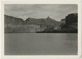
Norman D. Nevills' September 29-October 2, 1938 expedition for Philip W. Tompkins on the Colorado River from Moab down to near the mouth of the Green River. View of Colorado River and canyon.
1938-09-29; 1938-09-30; 1938-10-01; 1938-10-02
Image
uum_map_rr
33
Norman D. Nevills' September 29-October 2, 1938 expedition for Philip W. Tompkins on the Colorado River from Moab down to near the mouth of the Green River. View of Colorado River and canyon.
1938-09-29; 1938-09-30; 1938-10-01; 1938-10-02
Image
uum_map_rr
34
Norman D. Nevills' September 29-October 2, 1938 expedition for Philip W. Tompkins on the Colorado River from Moab down to near the mouth of the Green River. View of Colorado River and canyon.
1938-09-29; 1938-09-30; 1938-10-01; 1938-10-02
Image
uum_map_rr
35
Norman D. Nevills' September 29-October 2, 1938 expedition for Philip W. Tompkins on the Colorado River from Moab down to near the mouth of the Green River. View of Colorado River and canyon.
1938-09-29; 1938-09-30; 1938-10-01; 1938-10-02
Image
uum_map_rr
36
Norman D. Nevills' September 29-October 2, 1938 expedition for Philip W. Tompkins on the Colorado River from Moab down to near the mouth of the Green River. View of Colorado River and canyon.
1938-09-29; 1938-09-30; 1938-10-01; 1938-10-02
Image
uum_map_rr
37
Norman D. Nevills' September 29-October 2, 1938 expedition for Philip W. Tompkins on the Colorado River from Moab down to near the mouth of the Green River. View of Colorado River and canyon.
1938-09-29; 1938-09-30; 1938-10-01; 1938-10-02
Image
uum_map_rr
38
Norman D. Nevills' September 29-October 2, 1938 expedition for Philip W. Tompkins on the Colorado River from Moab down to near the mouth of the Green River. View of Colorado River and canyon.
1938-09-29; 1938-09-30; 1938-10-01; 1938-10-02
Image
uum_map_rr
39
Norman D. Nevills' September 29-October 2, 1938 expedition for Philip W. Tompkins on the Colorado River from Moab down to near the mouth of the Green River. View of Colorado River and canyon.
1938-09-29; 1938-09-30; 1938-10-01; 1938-10-02
Image
uum_map_rr
40
Norman D. Nevills' September 29-October 2, 1938 expedition for Philip W. Tompkins on the Colorado River from Moab down to near the mouth of the Green River. View of Colorado River and canyon.
1938-09-29; 1938-09-30; 1938-10-01; 1938-10-02
Image
uum_map_rr
41
Norman D. Nevills' September 29-October 2, 1938 expedition for Philip W. Tompkins on the Colorado River from Moab down to near the mouth of the Green River. View of Colorado River and canyon.
1938-09-29; 1938-09-30; 1938-10-01; 1938-10-02
Image
uum_map_rr
42
Norman D. Nevills' September 29-October 2, 1938 expedition for Philip W. Tompkins on the Colorado River from Moab down to near the mouth of the Green River. View of Colorado River and canyon.
1938-09-29; 1938-09-30; 1938-10-01; 1938-10-02
Image
uum_map_rr
43
Norman D. Nevills' September 29-October 2, 1938 expedition for Philip W. Tompkins on the Colorado River from Moab down to near the mouth of the Green River. View of Colorado River and canyon.
1938-09-29; 1938-09-30; 1938-10-01; 1938-10-02
Image
uum_map_rr
44
Norman D. Nevills' September 29-October 2, 1938 expedition for Philip W. Tompkins on the Colorado River from Moab down to near the mouth of the Green River. View of Colorado River and canyon.
1938-09-29; 1938-09-30; 1938-10-01; 1938-10-02
Image
uum_map_rr
45
Norman D. Nevills' September 29-October 2, 1938 expedition for Philip W. Tompkins on the Colorado River from Moab down to near the mouth of the Green River. View of Colorado River and canyon.
1938-09-29; 1938-09-30; 1938-10-01; 1938-10-02
Image
uum_map_rr
46
Needles District, Canyonlands, January 1980 [17]
1979-12; 1980-01
Image/StillImage
uum_map_rr
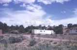
47
New housing for Island in the Sky, Canyonlands
1965-08-10
Image
uum_map
48
Southern Utah, March 1980 [01]
1980-03
Image/StillImage
uum_map_usa
49
Southern Utah, March 1980 [31]
1980-03
Image/StillImage
uum_map_usa
50
Doll House to Spanish Bottom, Canyonlands, spring 1969 [06]
1969
Image/StillImage
uum_map_rr
26
-
50
of
87
<
1
2
3
4
>