Home
Browse
Ask Us
Chat
Harmful Language Statement
Log in
Advanced Search
Year
1810
1811
1812
1813
1814
1815
1816
1817
1818
1819
1820
1821
1822
1823
1824
1825
1826
1827
1828
1829
1830
1831
1832
1833
1834
1835
1836
1837
1838
1839
1840
1841
1842
1843
1844
1845
1846
1847
1848
1849
1850
1851
1852
1853
1854
1855
1856
1857
1858
1859
1860
1861
1862
1863
1864
1865
1866
1867
1868
1869
1870
1871
1872
1873
1874
1875
1876
1877
1878
1879
1880
1881
1882
1883
1884
1885
1886
1887
1888
1889
1890
1891
1892
1893
1894
1895
1896
1897
1898
1899
1900
1901
1902
1903
1904
1905
1906
1907
1908
1909
1910
1911
1912
1913
1914
1915
1916
1917
1918
1919
1920
1921
1922
1923
1924
1925
1926
1927
1928
1929
1930
1931
1932
1933
1934
1935
1936
1937
1938
1939
1940
1941
1942
1943
1944
1945
1946
1947
1948
1949
1950
1951
1952
1953
1954
1955
1956
1957
1958
1959
1960
1961
1962
1963
1964
1965
1966
1967
1968
1969
1970
1971
1972
1973
1974
1975
1976
1977
1978
1979
1980
1981
1982
1983
1984
1985
1986
1987
1988
1989
1990
1991
1992
1993
1994
1995
1996
1997
1998
1999
2000
2001
2002
2003
2004
2005
2006
2007
2008
2009
2010
2011
2012
2013
2014
2015
2016
2017
2018
2019
2020
2021
2022
2023
2024
TO
1810
1811
1812
1813
1814
1815
1816
1817
1818
1819
1820
1821
1822
1823
1824
1825
1826
1827
1828
1829
1830
1831
1832
1833
1834
1835
1836
1837
1838
1839
1840
1841
1842
1843
1844
1845
1846
1847
1848
1849
1850
1851
1852
1853
1854
1855
1856
1857
1858
1859
1860
1861
1862
1863
1864
1865
1866
1867
1868
1869
1870
1871
1872
1873
1874
1875
1876
1877
1878
1879
1880
1881
1882
1883
1884
1885
1886
1887
1888
1889
1890
1891
1892
1893
1894
1895
1896
1897
1898
1899
1900
1901
1902
1903
1904
1905
1906
1907
1908
1909
1910
1911
1912
1913
1914
1915
1916
1917
1918
1919
1920
1921
1922
1923
1924
1925
1926
1927
1928
1929
1930
1931
1932
1933
1934
1935
1936
1937
1938
1939
1940
1941
1942
1943
1944
1945
1946
1947
1948
1949
1950
1951
1952
1953
1954
1955
1956
1957
1958
1959
1960
1961
1962
1963
1964
1965
1966
1967
1968
1969
1970
1971
1972
1973
1974
1975
1976
1977
1978
1979
1980
1981
1982
1983
1984
1985
1986
1987
1988
1989
1990
1991
1992
1993
1994
1995
1996
1997
1998
1999
2000
2001
2002
2003
2004
2005
2006
2007
2008
2009
2010
2011
2012
2013
2014
2015
2016
2017
2018
2019
2020
2021
2022
2023
2024
Type
Image
896
Image/StillImage
879
Sound
132
Text
107
Format
image/jpeg
1,621
application/pdf
295
video/mp4
100
audio/mpeg
32
Collection
Al W. Morton Collection, 1930s-1950s
1
American Westward Migration
6
Aziz Suryal Atiya papers
2
Beckwith Photograph Collection
1
Chieko N Okazaki papers
1
Classified Photographs
43
David Oman McKay Papers
1
Everett L. Cooley Oral History Project
1
Jacob Myers Sr. Papers, 1801-2009
1
John Hamilton Morgan Papers
1
Kent Day Family Collection
26
Land Use - Transportation Scenario Pl...
9
Lennox and Catherine Tierney Photogra...
179
Life Story Library collection
1
Lloyd and Kiyomi Takehara Ryujin Phot...
2
Manuscripts
1
Marriner S. Eccles Papers
1
Mormon Settlement in Arizona
1
Olympic Legacy
2
Photo Archives
1,204
Regional History Center
1
Shipler Commercial Photographers
1
Ski and Snow Sports Photo Archives
217
Taylor A. Woolley Papers
2
Theater Programs Collection, 1866-1995
1
Thorne Photographs
1
UAIDA Main Collection
43
Uintah County Regional History Center...
1
Utah Artists Project
2
Utah Humanities Research Foundation
5
Utah Quilt Heritage Records
11
Utah River Running Photo Archives
140
Western Soundscape
132
Western Waters Electronic Resources
7
Western Waters NEH
2
More
Filters:
Spatial Coverage:
"California"
Year End:
2012
1001
-
1025
of
2,050
<
36
37
38
39
40
41
42
43
44
45
>
Gallery view
Number of results to display per page
10
25
50
100
200
Sort by Relevance
Sort by Title A-Z
Sort by Title Z-A
Sort by Date Ascending
Sort by Date Descending
Sort by Last Modified Ascending
Sort by Last Modified Descending
Title
Date
Type
Setname
1001
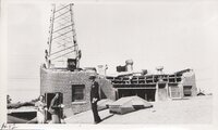
Long Beach earthquake, 1933: Radio KFOX transmitter, Long Beach
1933-03
Image/StillImage
uum_map
1002
Long Beach earthquake, 1933: Radio KFOX transmitter, Long Beach
1933-03
Image/StillImage
uum_map
1003
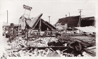
Long Beach earthquake, 1933: Ray's Dine & Dance, Compton
1933-03
Image/StillImage
uum_map
1004
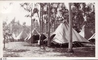
Long Beach earthquake, 1933: refugees camp, Los Angeles
1933-03
Image/StillImage
uum_map
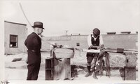
1005
Long Beach earthquake, 1933: Splicing broken telephone wires, Long Beach
1933-03
Image/StillImage
uum_map
1006
Long Beach earthquake, 1933: U.S. Marine, Long Beach
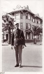
1921-08-08
Image/StillImage
uum_map
1007
Long Beach earthquake, 1933: US in Harbor
1933-03
Image/StillImage
uum_map
1008
Long Beach, California, June 1939 [01]
1939-06
Image/StillImage
uum_map
1009
Long Beach, California, June 1939 [02]
1939-06
Image/StillImage
uum_map
1010
Long Beach, California, June 1939 [03]
1939-06
Image/StillImage
uum_map
1011
Long Beach, California, June 1939 [04]
1939-06
Image/StillImage
uum_map
1012
Long-billed Dowitcher 2
2003-04-21
Sound
uu_wss
1013
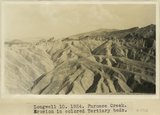
Longwell 10, Furnace Creek. Erosion in colored Tertiary beds
1924
Image
uum_map
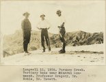
1014
Longwell 11, Furnace Creek. Tertiary beds near Mineral Monument. Professor Gregory, Dr. Noble, Dr. Hewett
1924
Image
uum_map
1015
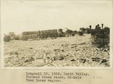
Longwell 12, Death Valley. Furnace Creek Ranch. 20-Mule Team Borax wagons
1924
Image
uum_map
1016
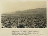
Longwell 13, Death Valley salt deposits, 9 miles south of Furnace Creek Ranch
1924
Image
uum_map
1017
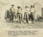
Longwell 7, 1924. Shoshone, Amoragosa Valley. Professor Gregory, Rocky Mountain George, Dr. Noble, Dr. Hewett
1924
Image
uum_map
1018
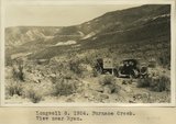
Longwell 8, 1924. Furnace Creek. View near Ryan
1924
Image
uum_map
1019
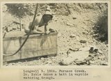
Longwell 9, Furnace Creek. Dr. Noble takes a bath in wayside water trough
1924
Image
uum_map
1020
Looking E along Leach Trough from 3200 ft. hill of fault breccia situated about 4 miles WSW of 2021 BM in Leach Trough at entrance of Paramint Valley
1924
Image
uum_map
1021
Looking N at Slate Range from 3200 ft. hill of fault breccia situated about 4 miles WSW of 2021 BM in Leach Trough at entrance of Paramint Valley. Outcrop of fault breccia in lower foreground
1924
Image
uum_map
1022
Looking out on south terrace and the sea
1940; 1941; 1942; 1943; 1944; 1945; 1946; 1947; 1948; 1949
Image/StillImage
uum_map
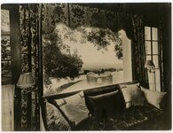
1023
Looking toward drawing room from library
1940; 1941; 1942; 1943; 1944; 1945; 1946; 1947; 1948; 1949
Image/StillImage
uum_map
1024
Looking up 364 feet to top of worlds tallest ree, Redwood Highway, Calif.
1900; 1901; 1902; 1903; 1904; 1905; 1906; 1907; 1908; 1909; 1910; 1911; 1912; 1913; 1914; 1915; 1916; 1917; 1918; 1919; 1920; 1921; 1922; 1923; 1924; 1925; 1926; 1927; 1928; 1929; 1930
Image
uum_map
1025
Looking westward from Cave Spring Wash along fault that crosses Cave Spring Wash at a point 5 miles below Cave Spring. The fault is probably the Leach Trough fault. Rocks at right of fault are indurated coarse red fanglomerate (possibly base of niter bed series); rocks at left are sheared and broden biotite gneiss
1924
Image
uum_map
1001
-
1025
of
2,050
<
36
37
38
39
40
41
42
43
44
45
>