| Title | Date | Type | Setname | ||
|---|---|---|---|---|---|
| 201 | 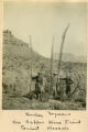 | Beecher, Seymour on Copper Mine Trail, Giant Mescals | 1900 | Image | uum_map |
| 202 | 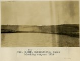 | Bekishibito: dunes blocking canyon, 1914 | 1914 | Image | uum_map |
| 203 | 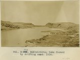 | Bekishibito: lake formed by drifting sand, 1914 | 1914 | Image | uum_map |
| 204 |  | Below Lava Falls | 1965-06 | Image | uum_map_rr |
| 205 |  | Below Lava Falls | 1965-06 | Image | uum_map_rr |
| 206 |  | Below Lava Falls | 1965-06 | Image | uum_map_rr |
| 207 |  | Below Lava Falls | 1965-06 | Image | uum_map_rr |
| 208 |  | Below Phantom Ranch after rain | 1965-06 | Image | uum_map_rr |
| 209 |  | Ben Johnson with three of his seven wives in front of their home in Mesa, Arizona. | 1885 | Image/StillImage | uum_map |
| 210 |  | Bernheimer Bridge | 1925; 1926; 1927; 1928; 1929; 1930; 1931; 1932; 1933; 1934; 1935; 1936; 1937; 1938; 1939; 1940; 1941; 1942; 1943; 1944; 1945; 1946; 1947; 1948; 1949 | Image | uum_map_rr |
| 211 |  | Bernheimer Bridge | 1925; 1926; 1927; 1928; 1929; 1930; 1931; 1932; 1933; 1934; 1935; 1936; 1937; 1938; 1939; 1940; 1941; 1942; 1943; 1944; 1945; 1946; 1947; 1948; 1949 | Image | uum_map_rr |
| 212 |  | Bernheimer Bridge | 1925; 1926; 1927; 1928; 1929; 1930; 1931; 1932; 1933; 1934; 1935; 1936; 1937; 1938; 1939; 1940; 1941; 1942; 1943; 1944; 1945; 1946; 1947; 1948; 1949 | Image | uum_map_rr |
| 213 |  | Bert Loper | 1940; 1941; 1942; 1943; 1944; 1945; 1946; 1947; 1948; 1949; 1950 | Image/StillImage | dha_alwmc |
| 214 |  | Bert Loper and others | 1940; 1941; 1942; 1943; 1944; 1945; 1946; 1947; 1948; 1949; 1950 | Image/StillImage | dha_alwmc |
| 215 |  | Bert Loper's Boat | 1940; 1941; 1942; 1943; 1944; 1945; 1946; 1947; 1948; 1949; 1950 | Image/StillImage | dha_alwmc |
| 216 |  | Beryl on Snowball, at V.K. ranch, April 1936 | 1936-04 | Image | uum_map |
| 217 |  | Betatakin cliff ruins, west branch of Sagy canon, Ariz., (Townsend photo, 1909) | 1909 | Image | uum_map |
| 218 |  | Betatakin Ruin, Sagy Canyon (Townsend photo) | 1910 | Image | uum_map |
| 219 |  | Betatakin, Navajo National Monument | 1935; 1936; 1937; 1938; 1939; 1940; 1941; 1942; 1943; 1944; 1945; 1946; 1947; 1948; 1949 | Image/StillImage | uum_map_rr |
| 220 | 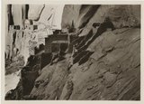 | Betatakin, Navajo National Monument | 1935; 1936; 1937; 1938; 1939; 1940; 1941; 1942; 1943; 1944; 1945; 1946; 1947; 1948; 1949 | Image/StillImage | uum_map_rr |
| 221 |  | Beveling and conglomerate cap of lower peneplain, north side Blue Canon, opposite old store. | 1913 | Image | uum_map |
| 222 |  | Beveling below Black Falls, looking north. | 1913 | Image | uum_map |
| 223 | 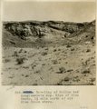 | Beveling of McElmo and conglomerate cap. Edge of Blue Canon, 1 1/2 mile north of old Blue Canon store. | 1913 | Image | uum_map |
| 224 | 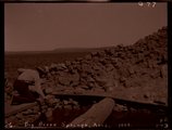 | Big Burro Springs, Arizona, 1909 (negative for photo G-77) | 1909 | Image | uum_map |
| 225 |  | Big Burro Springs, Arizona, 1909 (photo G-77) | 1909 | Image | uum_map |