| Title | Date | Type | Setname | ||
|---|---|---|---|---|---|
| 101 |  | Agathla, volcanic neck, between Chinlee, Ariz. and Oljato, Utah, 1910 (Photo G145) | 1910 | Image | uum_map |
| 102 | 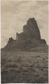 | Agathla, volcanic neck, between Chinlee, Ariz. and Oljato, Utah, 1910 (Photo G146) | 1910 | Image | uum_map |
| 103 |  | Agathla, volcanic neck, between Chinlee, Ariz. and Oljato, Utah, 1910 (Photo G146) | 1910 | Image | uum_map |
| 104 |  | Agathla, volcanic neck, between Chinlee, Ariz. and Oljato, Utah, 1910 (same as G145, Townsend photo) | 1910 | Image | uum_map |
| 105 | 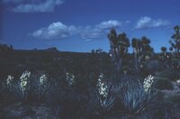 | Agaves and Joshua trees | 1940; 1941; 1942; 1943; 1944; 1945; 1946; 1947; 1948; 1949; 1950; 1951; 1952; 1953; 1954; 1955; 1956; 1957; 1958; 1959; 1960; 1961; 1962; 1963; 1964; 1965; 1966; 1967; 1968; 1969; 1970; 1971; 1972; 1973; 1974; 1975; 1976; 1977; 1978; 1979; 1980 | Image | uum_map_rr |
| 106 |  | Al Galloway, foreground; Eggert-Hatch River Expedition, June 1956 | 1956-06 | Image/StillImage | uum_map_rr |
| 107 |  | Al Morton | 1950; 1951; 1952; 1953; 1954; 1955; 1956; 1957; 1958; 1959; 1960 | Image/StillImage | dha_alwmc |
| 108 |  | Allen City minutes | 1876; 1877; 1878; 1879; 1880; 1881; 1882; 1883; 1884; 1885; 1886; 1887 | Text | uum_msa |
| 109 |  | Alluvium with peat. Top wall of Black Creek (VIII-66) (Photo G389) | 1913 | Image | uum_map |
| 110 |  | Altar Falls On Ribbon Creek | 1920; 1921; 1922; 1923; 1924; 1925; 1926; 1927; 1928; 1929 | Image/StillImage | uum_map |
| 111 |  | Amidst these wonderful monuments of south-eastern Utah, like the ruins of an ancient city | 1920; 1921; 1922; 1923 | Image/StillImage | uum_map |
| 112 |  | An-ti-naints, Pu-tu-siv and Wi-chuts, sitting | 1874 | Image/StillImage | uaida_main |
| 113 |  | Ancestors of Thora Bergeson Watson | 1964 | Text | uum_msa |
| 114 |  | Ancient irrigation ditch, La Plata sandstone, Moencopie wash, 10± mil east of Tuba, Ariz., 1909 (photo G-101) | 1909 | Image | uum_map |
| 115 |  | Ancient landslides, 5± mi. southwest of Sunrise Spgs., Ariz. (photo G-44) | 1909 | Image | uum_map |
| 116 |  | Ancient ruin, rim of Moenkopi Wash below Moenkopi village. | 1914 | Image | uum_map |
| 117 |  | Andrew Locy Rogers 1910 journal (copy of original) | 1910 | Text | uum_msa |
| 118 |  | Andrew Locy Rogers correspondence, 1878-1925 | 1878; 1879; 1897; 1900; 1920 | Text | uum_msa |
| 119 |  | Andrew Locy Rogers journal (original) | 1882; 1883; 1884; 1885; 1886; 1887; 1888; 1889; 1890; 1891; 1892; 1893; 1894; 1895; 1896; 1897; 1898; 1899; 1900; 1901; 1902 | Text | uum_msa |
| 120 |  | Andrew Locy Rogers journal (transcript) | 1969 | Text | uum_msa |
| 121 |  | Andrew Locy Rogers, Jr., and Rebecca Smith Rogers | 1900; 1901; 1902; 1903; 1904; 1905; 1906; 1907; 1908; 1909; 1910; 1911; 1912; 1913; 1914; 1915; 1916; 1917; 1918; 1919; 1920; 1921; 1922; 1923; 1924; 1925; 1926; 1927; 1928; 1929 | Text | uum_msa |
| 122 |  | Angel's Window | 1950; 1951; 1952; 1953; 1954; 1955; 1956; 1957; 1958; 1959; 1960 | Image/StillImage | dha_alwmc |
| 123 |  | Angel's Window | 1950; 1951; 1952; 1953; 1954; 1955; 1956; 1957; 1958; 1959; 1960 | Image/StillImage | dha_alwmc |
| 124 |  | Annual Report of the Commissioner of Indian Affairs for the year 1865 | 1865 | Text | uaida_main |
| 125 |  | Antelope petroglyphs, Monument Valley | 1935; 1936; 1937; 1938; 1939; 1940; 1941; 1942; 1943; 1944; 1945; 1946; 1947; 1948; 1949 | Image/StillImage | uum_map_rr |