| Title | Date | Type | Setname | ||
|---|---|---|---|---|---|
| 651 |  | Eastern Grand Canyon landscape, March 1962 [01] | 1962 | Image/StillImage | uum_map_rr |
| 652 |  | Eastern Grand Canyon landscape, March 1962 [02] | 1962 | Image/StillImage | uum_map_rr |
| 653 |  | Eastern Grand Canyon landscape, March 1962 [03] | 1962 | Image/StillImage | uum_map_rr |
| 654 | 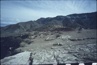 | Eastern Grand Canyon landscape, March 1962 [04] | 1962 | Image/StillImage | uum_map_rr |
| 655 | 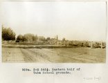 | Eastern half of Tuba school grounds | 1914 | Image | uum_map |
| 656 |  | Eastern half of Tuba school grounds, 1914. | 1914 | Image/StillImage | uum_map |
| 657 |  | Edna's Needle, LaPlata, west of Chinlee. VII, 29 (Photo G274) | 1911 | Image | uum_map |
| 658 |  | Eggert in wee inflatable boat being "rescued," June 1956 | 1956-06 | Image/StillImage | uum_map_rr |
| 659 |  | El Tovar Hotel | 1920; 1921; 1922; 1923; 1924; 1925; 1926; 1927; 1928; 1929 | Image/StillImage | uum_map |
| 660 | 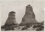 | Elephant Feet, Arizona | 1920; 1921; 1922; 1923; 1924; 1925; 1926; 1927; 1928; 1929; 1930; 1931; 1932; 1933; 1934; 1935; 1936; 1937; 1938; 1939; 1940; 1941; 1942; 1943; 1944; 1945; 1946; 1947; 1948; 1949 | Image/StillImage | uum_map_rr |
| 661 | 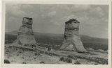 | Elephant Rocks, Arizona | 1928-08 | Image | uum_map_rr |
| 662 | 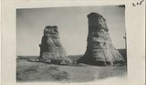 | Elephant's Feet | 1925; 1926; 1927; 1928; 1929; 1930; 1931; 1932; 1933; 1934; 1935; 1936; 1937; 1938; 1939; 1940; 1941; 1942; 1943; 1944; 1945; 1946; 1947; 1948; 1949 | Image | uum_map_rr |
| 663 |  | Elephant's feet | 1925; 1926; 1927; 1928; 1929; 1930; 1931; 1932; 1933; 1934; 1935; 1936; 1937; 1938; 1939; 1940; 1941; 1942; 1943; 1944; 1945; 1946; 1947; 1948; 1949 | Image | uum_map_rr |
| 664 | 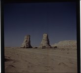 | Elephant's Feet, near Navajo Mt., April 1952 [01] | 1952-04 | Image | uum_map |
| 665 |  | Elephant's Feet, near Navajo Mt., April 1952 [02] | 1952-04 | Image | uum_map |
| 666 |  | Elephant's Feet, Route 64 and 1, Arizona, May 26, 1962 | 1962-05-26 | Image | uum_map |
| 667 |  | Elve's Chasm | 1965-06 | Image | uum_map_rr |
| 668 |  | Elve's Chasm | 1965-06 | Image | uum_map_rr |
| 669 |  | Elves Chasm | 1965-06 | Image | uum_map_rr |
| 670 |  | Emery Kolb | 1951 | Image/StillImage | dha_alwmc |
| 671 |  | End of run, Hance Rapid June 1956 | 1956-06 | Image/StillImage | uum_map_rr |
| 672 | 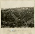 | Entrenched meanders, Blue Canyon | 1913 | Image | uum_map |
| 673 |  | Erastus Snow correspondence, 1878-1886 | 1878; 1886 | Text | uum_msa |
| 674 | 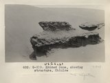 | Eroded Dune, showing structure, Chinlee (Photo G319) | 1913 | Image | uum_map |
| 675 |  | Eroded neck at northwest corner of Moqui Butte area (Photo G233) | 1911 | Image | uum_map |