Home
Browse
Ask Us
Chat
Harmful Language Statement
Log in
Advanced Search
Year
1849
1850
1851
1852
1853
1854
1855
1856
1857
1858
1859
1860
1861
1862
1863
1864
1865
1866
1867
1868
1869
1870
1871
1872
1873
1874
1875
1876
1877
1878
1879
1880
1881
1882
1883
1884
1885
1886
1887
1888
1889
1890
1891
1892
1893
1894
1895
1896
1897
1898
1899
1900
1901
1902
1903
1904
1905
1906
1907
1908
1909
1910
1911
1912
1913
1914
1915
1916
1917
1918
1919
1920
1921
1922
1923
1924
1925
1926
1927
1928
1929
1930
1931
1932
1933
1934
1935
1936
1937
1938
1939
1940
1941
1942
1943
1944
1945
1946
1947
1948
1949
1950
1951
1952
1953
1954
1955
1956
1957
1958
1959
1960
1961
1962
1963
1964
1965
1966
1967
1968
1969
1970
1971
1972
1973
1974
1975
1976
1977
1978
1979
1980
1981
1982
1983
1984
1985
1986
1987
1988
1989
1990
1991
1992
1993
1994
1995
1996
1997
1998
1999
2000
2001
2002
2003
2004
2005
2006
2007
2008
2009
2010
2011
2012
2013
2014
2015
2016
2017
2018
2019
2020
2021
2022
2023
TO
1849
1850
1851
1852
1853
1854
1855
1856
1857
1858
1859
1860
1861
1862
1863
1864
1865
1866
1867
1868
1869
1870
1871
1872
1873
1874
1875
1876
1877
1878
1879
1880
1881
1882
1883
1884
1885
1886
1887
1888
1889
1890
1891
1892
1893
1894
1895
1896
1897
1898
1899
1900
1901
1902
1903
1904
1905
1906
1907
1908
1909
1910
1911
1912
1913
1914
1915
1916
1917
1918
1919
1920
1921
1922
1923
1924
1925
1926
1927
1928
1929
1930
1931
1932
1933
1934
1935
1936
1937
1938
1939
1940
1941
1942
1943
1944
1945
1946
1947
1948
1949
1950
1951
1952
1953
1954
1955
1956
1957
1958
1959
1960
1961
1962
1963
1964
1965
1966
1967
1968
1969
1970
1971
1972
1973
1974
1975
1976
1977
1978
1979
1980
1981
1982
1983
1984
1985
1986
1987
1988
1989
1990
1991
1992
1993
1994
1995
1996
1997
1998
1999
2000
2001
2002
2003
2004
2005
2006
2007
2008
2009
2010
2011
2012
2013
2014
2015
2016
2017
2018
2019
2020
2021
2022
2023
Type
Image
2,258
Image/StillImage
1,644
Text
189
Image/MovingImage
3
Sound
2
Format
image/jpeg
3,577
application/pdf
477
video/mp4
3
audio/mpeg
2
Institution
University of Utah Marriott Library
3,694
Department of Cultural and Community ...
302
Utah American Indian Digital Archive
111
Utah Museum of Natural History
7
University of Utah Partnerships
5
Delta City Library
2
Uintah County Library
2
More
Collection
Al W. Morton Collection, 1930s-1950s
55
American Westward Migration
3
Audio-Visual Archives Collections
2
Beckwith Photograph Collection
2
Classified Photographs
245
George A. Smith Papers
1
Mormon Settlement in Arizona
164
Photo Archives
1,921
Shipler Commercial Photographers
2
UAIDA Main Collection
111
Uintah County Regional History Center...
1
Utah Humanities Research Foundation
5
Utah River Running Photo Archives
1,601
Vernal Express Photographs
1
Vertebrate Zoology Field Notes
7
Western Soundscape
2
More
Filters:
Spatial Coverage:
"Arizona"
Year End:
1969
526
-
550
of
4,123
<
17
18
19
20
21
22
23
24
25
26
>
Gallery view
Number of results to display per page
10
25
50
100
200
Sort by Relevance
Sort by Title A-Z
Sort by Title Z-A
Sort by Date Ascending
Sort by Date Descending
Sort by Last Modified Ascending
Sort by Last Modified Descending
Title
Date
Type
Setname
526
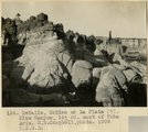
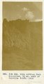
Details, McElmo or La Plata (?), Blue Canyon, 18± mi. east of Tuba, Ariz. (M. R. Campbell photo, 1909, U.S.G.S.)
1909
Image
uum_map
527
Diamond jubilee gems: Snowflake Stake of Zion
1962
Text
uum_msa
528
Diaries of John Bushman, 1871-1923, part 1: 1871-1889
1871; 1872; 1873; 1874; 1875; 1876; 1877; 1878; 1879; 1880; 1881; 1882; 1883; 1884; 1885; 1886; 1887; 1888; 1889
Text
uum_msa
529
Diaries of John Bushman, 1871-1923, part 2: 1890-1923
1890; 1891; 1892; 1893; 1894; 1895; 1896; 1897; 1898; 1899; 1900; 1901; 1902; 1903; 1904; 1905; 1906; 1907; 1908; 1909; 1910; 1911; 1912; 1913; 1914; 1915; 1916; 1917; 1918; 1919; 1920; 1921; 1922; 1923
Text
uum_msa
530
Diary of Andrew Smith Gibbons, 1858, 1877, 1878
1858; 1877; 1888
Text
uum_msa
531
Diary of John McLaws, Jr., transcript
1852; 1853; 1854; 1855; 1856; 1857; 1858; 1859; 1860; 1861; 1862; 1863; 1864; 1865; 1866; 1867; 1868; 1869; 1870; 1871; 1872; 1873; 1874; 1875; 1876; 1877; 1878; 1879; 1880; 1881; 1882; 1883; 1884; 1885; 1886; 1887; 1888; 1889; 1890; 1891; 1892; 1893; 1894; 1895
Text
uum_msa
532
Diary of William Henry Solomon, 1873 and 1874 (excerpts)
1873; 1874
Text
uum_msa
533
Dike "B", east of Baigaiche Mt. VI, 45, 55. 1911 (Photo N-M114)
1911
Image
uum_map
534
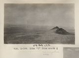
Dike "T" from south 1/2 (Photo G399)
1913
Image
uum_map
535
Dike (diabase), Stiles Ranche 30± mi. north of Winslow, AZ. 1911 (Photo G237)
1911
Image
uum_map
536
Dike (diabase), Stiles Ranche, 30± mi. north of Winslow, AZ. 1911 (Photo G236)
1911
Image
uum_map
537
Dike (diabase), Stiles Ranche, 30± mi. north of Winslow, AZ. 1911 (Photo G236)
1911
Image
uum_map
538
Dike (diabase?), Stiles Ranche, Moqui Buttes region, AZ. 1911 (Photo G235)
1911
Image
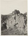
uum_map
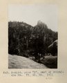
539
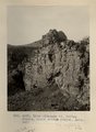
Dike (diabase?), Stiles Ranche, Moqui Buttes region, AZ. 1911 (Photo G235)
1911
Image
uum_map
540
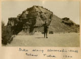
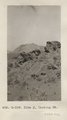
Dike along Moencopie near Tuba, 1900
1900
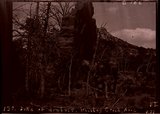
Image
uum_map
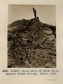
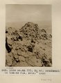
541
Dike along Moencopie Wash below Tuba 1900
1900
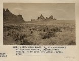
Image
uum_map
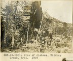
542
Dike at Sonsala Buttes. South bank of Whiskey Creek, looking west toward Sonsala Buttes (Photo G295)
1911
Image
uum_map
543
Dike cutting Comb Monocline, 3± mi. east of Colville dikes, 1914
1914
Image
uum_map
544
Dike east of Dike no. 2, Laguna Creek valley, Ariz., 1910 (Photo N-M87)
1910
Image
uum_map
545
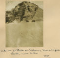
Dike in La Plata or Dolores, Moencopie Wash, near Tuba, 1900
1900
Image
uum_map
546
Dike J, looking NE (Photo G339)
1913
Image
uum_map
547
Dike no. 3, 6+ mi. southeast of Agathla Needle, Laguna Creek valley, view from southeast, Ariz., 1910 (Photo G148)
1910
Image
uum_map
548
Dike no. 4A 2+ mil. southeast of Cha-ez Kla, Ariz., 1910.
1910
Image
uum_map
549
Dike of diabase, Whiskey Creek, Ariz. (negative for photo G-102)
1909
Image
uum_map
550
Dike of diabase, Whiskey Creek, Ariz., 1909 (photo G-102)
1909
Image
uum_map
526
-
550
of
4,123
<
17
18
19
20
21
22
23
24
25
26
>