Home
Browse
Ask Us
Chat
Harmful Language Statement
Log in
Advanced Search
Year
1849
1850
1851
1852
1853
1854
1855
1856
1857
1858
1859
1860
1861
1862
1863
1864
1865
1866
1867
1868
1869
1870
1871
1872
1873
1874
1875
1876
1877
1878
1879
1880
1881
1882
1883
1884
1885
1886
1887
1888
1889
1890
1891
1892
1893
1894
1895
1896
1897
1898
1899
1900
1901
1902
1903
1904
1905
1906
1907
1908
1909
1910
1911
1912
1913
1914
1915
1916
1917
1918
1919
1920
1921
1922
1923
1924
1925
1926
1927
1928
1929
1930
1931
1932
1933
1934
1935
1936
1937
1938
1939
1940
1941
1942
1943
1944
1945
1946
1947
1948
1949
1950
1951
1952
1953
1954
1955
1956
1957
1958
1959
1960
1961
1962
1963
1964
1965
1966
1967
1968
1969
1970
1971
1972
1973
1974
1975
1976
1977
1978
1979
1980
1981
1982
1983
1984
1985
1986
1987
1988
1989
1990
1991
1992
1993
1994
1995
1996
1997
1998
1999
2000
2001
2002
2003
2004
2005
2006
2007
2008
2009
2010
2011
2012
2013
2014
2015
2016
2017
2018
2019
2020
2021
2022
2023
TO
1849
1850
1851
1852
1853
1854
1855
1856
1857
1858
1859
1860
1861
1862
1863
1864
1865
1866
1867
1868
1869
1870
1871
1872
1873
1874
1875
1876
1877
1878
1879
1880
1881
1882
1883
1884
1885
1886
1887
1888
1889
1890
1891
1892
1893
1894
1895
1896
1897
1898
1899
1900
1901
1902
1903
1904
1905
1906
1907
1908
1909
1910
1911
1912
1913
1914
1915
1916
1917
1918
1919
1920
1921
1922
1923
1924
1925
1926
1927
1928
1929
1930
1931
1932
1933
1934
1935
1936
1937
1938
1939
1940
1941
1942
1943
1944
1945
1946
1947
1948
1949
1950
1951
1952
1953
1954
1955
1956
1957
1958
1959
1960
1961
1962
1963
1964
1965
1966
1967
1968
1969
1970
1971
1972
1973
1974
1975
1976
1977
1978
1979
1980
1981
1982
1983
1984
1985
1986
1987
1988
1989
1990
1991
1992
1993
1994
1995
1996
1997
1998
1999
2000
2001
2002
2003
2004
2005
2006
2007
2008
2009
2010
2011
2012
2013
2014
2015
2016
2017
2018
2019
2020
2021
2022
2023
Type
Image
2,389
Image/StillImage
2,048
Text
235
Image/MovingImage
3
Sound
2
Format
image/jpeg
4,114
application/pdf
514
video/mp4
3
audio/mpeg
2
Collection
Al W. Morton Collection, 1930s-1950s
55
American Westward Migration
3
Audio-Visual Archives Collections
2
Beckwith Photograph Collection
2
Classified Photographs
245
George A. Smith Papers
1
Glen Canyon
1
Mormon Settlement in Arizona
205
Photo Archives
1,923
Shipler Commercial Photographers
2
UAIDA Main Collection
113
Uintah County Regional History Center...
2
Utah Humanities Research Foundation
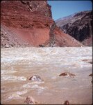
5
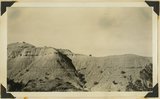
Utah River Running Photo Archives
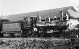
2,133
Vernal Express Photographs
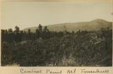
1
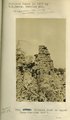
Western Soundscape
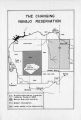
2
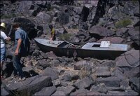
Western Waters Documents
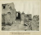
2
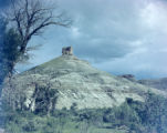
More
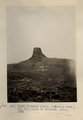
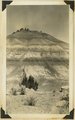
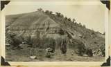
Filters:
Spatial Coverage:
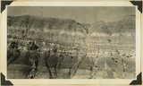
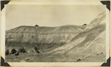
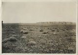
"Arizona"
Year End:
1979
401
-
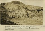
425
of
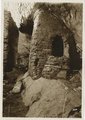
4,697
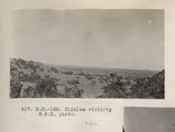
<
12
13
14
15
16
17
18
19
20
21
>
Gallery view
Number of results to display per page
10
25
50
100
200
Sort by Relevance
Sort by Title A-Z
Sort by Title Z-A
Sort by Date Ascending
Sort by Date Descending
Sort by Last Modified Ascending
Sort by Last Modified Descending
Title
Date
Type
Setname
401
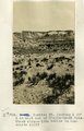
Carrizo Mt. looking S 30° E at west end of Chejin-Dezah Mesa. Shows cirque-like basins in monsonite cliff
1913
Image
uum_map
402
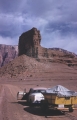
Cathedral Rock on the road to Lees Ferry, Arizona, 1960
1960
Image
uum_map
403
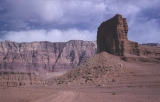
Cathedral Rock on the road to Lees Ferry, Arizona, before Grand Canyon boating trip
1960
Image
uum_map
404
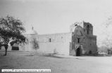
Catholic Churches p.4
1930; 1931; 1932; 1933; 1934; 1935; 1936; 1937; 1938; 1939
Image
dha_cp
405
Cause of Hance Rapid, Granite vein, June 1956
1956-06
Image/StillImage
uum_map_rr
406
Cedar Ridge. Cap of Shinarump conglomerate and upper Moenkopi extending south from Vermillion Cliffs onto Uinkaret Plateau west of Pipe Wash, Mohave County, AZ. 1939
1939
Image
uum_map
407
Central Pacific RR - Locomotives P.13
1895
Image/StillImage
dha_cp
408
Central Pacific RR - Locomotives P.14
1894; 1895
Image/StillImage
dha_cp
409
Central point, Mt. Trumbull
1900
Image
uum_map
410
Cha-ez Kla. (No. 4). Volcanic neck or dike, 2+ mi, south of Agathla Needle, Ariz., 1910 (Photo G147)
1910
Image
uum_map
411
The Changing Navajo Reservation
1882; 1868; 1880; 1882; 1884; 1892; 1900; 1901; 1905; 1914; 1915; 1918; 1930; 1931; 1933; 1934
Text
uaida_main
412
Charles Russell boat, Grand Canyon, June 1971
1971
Image/StillImage
uum_map_rr
413
Chief Harry Supela (naked) about to enter snake kiva at Walpi, morning of snake dance. Great altar is partly seen through the covered passage way
1915
Image
uum_map
414
Chimney Butte
1945; 1946; 1947; 1948; 1949; 1950
Image/StillImage
dha_alwmc
415
Chimney Butte, volcanic neck, 25± mi. north of Winslow, AZ. 1911 (Photo G240)
1911
Image
uum_map
416
Chimney Rock on Tees-Nos-Pos trail
1913
Image
uum_map
417
Chinle "marls," Sand Wash, Mohave County, Arizona, 1936.
1936
Image
uum_map
418
Chinle "marls," Sand Wash, Mohave County, Arizona, 1936.
1936
Image
uum_map
419
Chinle "marls," Sand Wash, Mohave County, Arizona, 1936.
1936
Image
uum_map
420
Chinle "marls," Sand Wash, Mohave County, Arizona, 1936.
1936
Image
uum_map
421
Chinle "marls," Sand Wash, Mohave County, Arizona, 1936.
1936
Image
uum_map
422
Chinle shales at Echo Peak, Coconino County, Arizona. Standing on Shinarump conglomerate. June 6, 1915.
1915
Image
uum_map
423
Chinle Wash
1925; 1926; 1927; 1928; 1929; 1930; 1931; 1932; 1933; 1934; 1935; 1936; 1937; 1938; 1939; 1940; 1941; 1942; 1943; 1944; 1945; 1946; 1947; 1948; 1949
Image
uum_map_rr
424
Chinle Wash ruins
1935; 1936; 1937; 1938; 1939; 1940; 1941; 1942; 1943; 1944; 1945; 1946; 1947; 1948; 1949
Image/StillImage
uum_map_rr
425
Chinlee vicinity W.B.E. photo (Photo N-M152)
1913
Image
uum_map
401
-
425
of
4,697
<
12
13
14
15
16
17
18
19
20
21
>