| | Title | Date | Type | Setname |
|---|
| 1 | 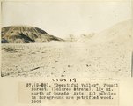 | "Beautiful Valley." Fossil forest (Dolores strata), 12± mi. north of Ganado, Ariz. All pebbles in foreground are petrified wood, 1909 (photo G-28) | 1909 | Image | uum_map |
| 2 | 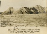 | "Beautiful Valley." Fossil forest, Dolores strata, 12± mi. north of Ganado, Ariz., 1909 (photo G-31) | 1909 | Image | uum_map |
| 3 | 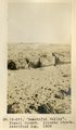 | "Beautiful Valley." Fossil forest, Dolores strata, petrified log, 1909 (photo G-29) | 1909 | Image | uum_map |
| 4 |  | "Blue Canyon" 18± mil east of Tuba, Ariz., McElmo overlain by Dakota (W. C. Mendenhall, U.S.G.S. photo) | 1909 | Image | uum_map |
| 5 | 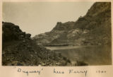 | "Dugway," Lees Ferry 1900 | 1900 | Image | uum_map |
| 6 | 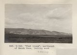 | "Flat irons", northeast of Marsh Pass, looking west (Photo G346) | 1913 | Image | uum_map |
| 7 |  | "House Rock against Vermillion cliffs." | 1941 | Image | uum_map |
| 8 |  | "How the Horse Helped Build America." Chapter 18, No.15. Riding is popular on ranches for guests in the Phoenix, Arizona area. | 1940; 1941; 1942; 1943; 1944; 1945; 1946; 1947; 1948; 1949; 1950; 1951; 1952; 1953; 1954; 1955; 1956; 1957; 1958; 1959; 1960; 1961; 1962; 1963; 1964; 1965; 1966; 1967; 1968; 1969; 1970 | Image | uum_map |
| 9 |  | "How the Horse Helped Build America." Chapter 18, No.16. Horse riding, Grand Canyon | 1940; 1941; 1942; 1943; 1944; 1945; 1946; 1947; 1948; 1949; 1950; 1951; 1952; 1953; 1954; 1955; 1956; 1957; 1958; 1959; 1960; 1961; 1962; 1963; 1964; 1965; 1966; 1967; 1968; 1969; 1970 | Image | uum_map |
| 10 |  | "How the Horse Helped Build America." Chapter 18, No.17. Bumper to Bumper across the Colorado | 1940; 1941; 1942; 1943; 1944; 1945; 1946; 1947; 1948; 1949; 1950; 1951; 1952; 1953; 1954; 1955; 1956; 1957; 1958; 1959; 1960; 1961; 1962; 1963; 1964; 1965; 1966; 1967; 1968; 1969; 1970 | Image | uum_map |
| 11 |  | "How the Horse Helped Build America." Chapter 18. No. 29. Horses for herding buffalo | 1948-12-12 | Image | uum_map |
| 12 |  | "Kit Carson's Monument," eroded from Moencopie (Permian?_ sandstone near Fort Defiance, Arizona, 1909 (photo G-12) | 1909 | Image | uum_map |
| 13 |  | "Monument" in Painted Desert formation east of Tanners Crossing. | 1913 | Image | uum_map |
| 14 |  | "North Forest", Carrizo Creek Wash (Photo G447) | 1913 | Image | uum_map |
| 15 |  | "Old Ironsides," Bass [boat named ROSS WHEELER] | 1971-08-20 | Image | uum_map_rr |
| 16 |  | "Old Ironsides," Bass [boat named ROSS WHEELER] | 1971-08-20 | Image | uum_map_rr |
| 17 | 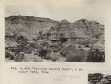 | "Painted Desert Bads", 1 mi. below Farm, Tuba (Photo G432) | 1913 | Image | uum_map |
| 18 | 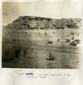 | "Painted Desert", 2 mi. west of Tuba | 1913 | Image | uum_map |
| 19 | 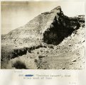 | "Painted Desert", four miles west of Tuba | 1913 | Image | uum_map |
| 20 | 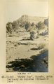 | "Round Top," Ganado, Ariz. Tertiary on Dolores (Triassic), 1909 (photo G-36) | 1909 | Image | uum_map |
| 21 | 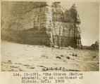 | "The Church" (McElmo strata?), 4± mi southeast of Hlohala, Ariz., 1909 (photo G-107) | 1909 | Image | uum_map |
| 22 | 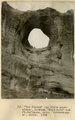 | "The Window" (La Plata sandstone), between "Haystacks" and Ft. Defiance, Ariz. (Schwemberger photo), 1906 | 1906 | Image | uum_map |
| 23 | 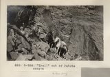 | "Trail" out of PahUte canyon (Photo G354) | 1913 | Image | uum_map |
| 24 |  | "Windsor Castle," Pipe Springs, 1936. | 1936 | Image | uum_map |
| 25 |  | "Yaqui" Easter Ceremonial in Tuscan, Arizona [01] | 1941; 1942; 1943; 1944; 1945; 1946; 1947; 1948; 1949; 1950; 1951; 1952; 1953; 1954; 1955 | Image | uum_map |
| 26 |  | "Yaqui" Easter Ceremonial in Tuscan, Arizona [02] | 1941; 1942; 1943; 1944; 1945; 1946; 1947; 1948; 1949; 1950; 1951; 1952; 1953; 1954; 1955 | Image | uum_map |
| 27 |  | 'Winsor Castle', old fort at Pipe Springs, looking south over Unikaret Plateau, Kanab Canyon upper right | 1939 | Image | uum_map |
| 28 |  | 'Winsor Castle,' old stone fort at Pipe Springs, Mohave County, AZ. Sevier fault passes between Navajo sandstone." (upper right) and lower Moenkopi (foreground). 1939 | 1939 | Image | uum_map |
| 29 |  | 10-man rafts from Oregon, Pete Cameron | 1971-05-06 | Image | uum_map_rr |
| 30 |  | 10-man rafts from Oregon, Pete Cameron | 1971-05-06 | Image | uum_map_rr |
| 31 | 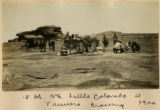 | 15 Miles NE Little Colorado at Tanners Crossing 1900 | 1900 | Image | uum_map |
| 32 |  | 20 mules in a train | 1909 | Image | uum_map |
| 33 |  | 24 ½ Rapid, Grand Canyon, Nevills Expedition Grand Canyon river trip, 1942 | 1942 | Image | uum_map_rr |
| 34 |  | 3± mi. north of Ganado, Ariz. Tertiary in angular unconformity with Dolores (Triassic), 1909 (photo G-37) | 1909 | Image | uum_map |
| 35 |  | 3± mi. north of Ganado. Tertiary unconformable on Dolores. VII, 19. 1911 (Photo G218) | 1911 | Image | uum_map |
| 36 | 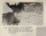 | 3± mi. north of Tucker Spgs. Green bands in Permian shale just below Shinarump, showing secondary origin. Shinarump in blocks (Photo N-M170) | 1913 | Image | uum_map |
| 37 | 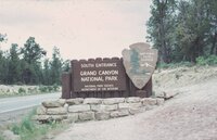 | [entrance sign for Grand Canyon National Park, South Rim] | 1970-06 | Image | uum_map_rr |
| 38 |  | [Faulting in rock layers, probably Kanab Creek Canyon, Arizona, 1922] | 1922 | Image | uum_map |
| 39 |  | [Whiskey Creek palisades] (Photo N-M130) | 1911 | Image | uum_map |
| 40 |  | A Navajo 1910 | 1909 | Image | uum_map |
| 41 |  | A nearer view of G-48 (volcanic neck between Sunrise Springs and Biddehoche), 1909 (photo G-49) | 1909 | Image | uum_map |
| 42 |  | A. M. Thompson, Kanab Creek, 1872. | 1872 | Image | uum_map |
| 43 |  | Above Hance [rapid] | 1970-04; 1970-05 | Image | uum_map_rr |
| 44 |  | Above Kanab Creek | 1970-04; 1970-05 | Image | uum_map_rr |
| 45 | 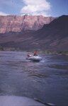 | Above Unkar [rapid] | 1970-04; 1970-05 | Image | uum_map_rr |
| 46 |  | Above Unkar [rapid] | 1970-04; 1970-05 | Image | uum_map_rr |
| 47 | 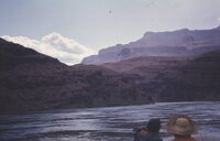 | Above Unkar [rapid] | 1970-04; 1970-05 | Image | uum_map_rr |
| 48 | 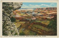 | Across from Grand View Point, Grand Canyon National Park, Arizona | 1930; 1931; 1932; 1933; 1934; 1935; 1936; 1937; 1938; 1939; 1940; 1941; 1942; 1943; 1944; 1945 | Image | uum_map |
| 49 |  | Aerial of construction camp | 1958-04 | Image | uum_map_rr |
| 50 | 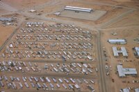 | Aerial of construction camp | 1958-10 | Image | uum_map_rr |
| 51 | 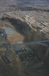 | Aerial of dam site with rising dam | 1961-05 | Image | uum_map_rr |
| 52 | 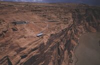 | Aerial of north side of canyon, paved view area. | 1962-08 | Image | uum_map_rr |
| 53 |  | Aerial photo of dam site. | 1958-04 | Image | uum_map_rr |
| 54 |  | Aerial photo of dam site. | 1958-04 | Image | uum_map_rr |
| 55 | 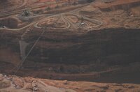 | Aerial photo of dam site. | 1958-10 | Image | uum_map_rr |
| 56 |  | Aerial photo of dam site. | 1958-04 | Image | uum_map_rr |
| 57 |  | Aerial photo of dam site. | 1958-10 | Image | uum_map_rr |
| 58 | 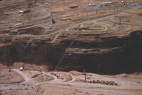 | Aerial photo of dam site. | 1958-04 | Image | uum_map_rr |
| 59 | 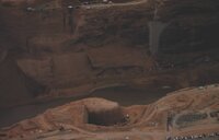 | Aerial photo of dam site. | 1958-10 | Image | uum_map_rr |
| 60 | 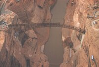 | Aerial photos of dam site and bridge construction. | 1958-10 | Image | uum_map_rr |
| 61 | 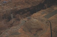 | Aerial photos of dam site and bridge construction. | 1958-10 | Image | uum_map_rr |
| 62 |  | Aerial photos of dam site and bridge construction. | 1958-10 | Image | uum_map_rr |
| 63 | 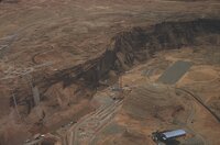 | Aerial photos of dam site and bridge construction. | 1958-10 | Image | uum_map_rr |
| 64 | 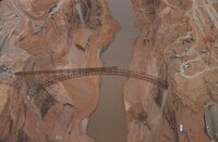 | Aerial photos of dam site and bridge construction. | 1958-10 | Image | uum_map_rr |
| 65 |  | Aerial photos of dam site and bridge construction. | 1958-10 | Image | uum_map_rr |
| 66 |  | Aerial photos of dam site and bridge construction. | 1958-10 | Image | uum_map_rr |
| 67 | 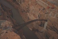 | Aerial photos of dam site and bridge construction. | 1958-10 | Image | uum_map_rr |
| 68 | 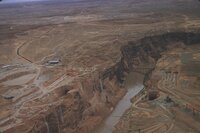 | Aerial photos of dam site and Page, Arizona | 1958-10 | Image | uum_map_rr |
| 69 |  | Aerial tramway, batch plant | 1962-08 | Image | uum_map_rr |
| 70 |  | After the dance, Walpi, AZ | 1915 | Image | uum_map |
| 71 |  | Agathla (John Wetherill photo) | 1910 | Image | uum_map |
| 72 |  | Agathla and Slim (Queen) Rock, Ariz., from S.E. (Photo G144) | 1910 | Image | uum_map |
| 73 |  | Agathla and Slim (Queen) Rock, Ariz., from S.E. (Photo G144) | 1910 | Image | uum_map |
| 74 |  | Agathla and Slim (Queen) Rock, Ariz., from S.E. (Photo N-M86) | 1910 | Image | uum_map |
| 75 |  | Agathla, volcanic neck, between Chinlee, Ariz. and Oljato, Utah, 1910 (Photo G145) | 1910 | Image | uum_map |
| 76 |  | Agathla, volcanic neck, between Chinlee, Ariz. and Oljato, Utah, 1910 (Photo G145) | 1910 | Image | uum_map |
| 77 | 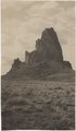 | Agathla, volcanic neck, between Chinlee, Ariz. and Oljato, Utah, 1910 (Photo G146) | 1910 | Image | uum_map |
| 78 |  | Agathla, volcanic neck, between Chinlee, Ariz. and Oljato, Utah, 1910 (Photo G146) | 1910 | Image | uum_map |
| 79 |  | Agathla, volcanic neck, between Chinlee, Ariz. and Oljato, Utah, 1910 (same as G145, Townsend photo) | 1910 | Image | uum_map |
| 80 | 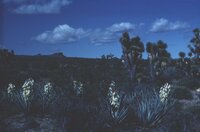 | Agaves and Joshua trees | 1940; 1941; 1942; 1943; 1944; 1945; 1946; 1947; 1948; 1949; 1950; 1951; 1952; 1953; 1954; 1955; 1956; 1957; 1958; 1959; 1960; 1961; 1962; 1963; 1964; 1965; 1966; 1967; 1968; 1969; 1970; 1971; 1972; 1973; 1974; 1975; 1976; 1977; 1978; 1979; 1980 | Image | uum_map_rr |
| 81 |  | Alluvium with peat. Top wall of Black Creek (VIII-66) (Photo G389) | 1913 | Image | uum_map |
| 82 |  | Ancient irrigation ditch, La Plata sandstone, Moencopie wash, 10± mil east of Tuba, Ariz., 1909 (photo G-101) | 1909 | Image | uum_map |
| 83 |  | Ancient landslides, 5± mi. southwest of Sunrise Spgs., Ariz. (photo G-44) | 1909 | Image | uum_map |
| 84 | 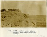 | Ancient ruin, rim of Moenkopi Wash below Moenkopi village. | 1914 | Image | uum_map |
| 85 |  | Apache Indians P.1 | 1885 | Image | dha_cp |
| 86 |  | Apache Lodge | 1934 | Image | uum_map_rr |
| 87 |  | Arizona department of water resources: Securing Arizona's water future | 1998; 1999; 2000; 2001; 2002; 2003; 2004 | Text; Image | wwdl_er |
| 88 |  | Arizona Peace Officer at Short Creek Home | 1953 | Image | dha_cp |
| 89 | | Arizona Water Science Center | 2005-01-19 | Text; Image | wwdl_er |
| 90 |  | Arizona, Jerome | 1890; 1891; 1892; 1893; 1894; 1895; 1896; 1897; 1898 | Image | uum_map |
| 91 |  | Arizona, Jerome | 1930; 1931; 1932; 1933; 1934; 1935; 1936; 1937; 1938; 1939; 1940; 1941; 1942; 1943; 1944; 1945; 1946; 1947; 1948; 1949; 1950; 1951; 1952; 1953; 1954; 1955; 1956; 1957; 1958; 1959; 1960 | Image | uum_map |
| 92 |  | Arizona, Tombstone, before 1880 | 1877; 1878; 1879 | Image | uum_map |
| 93 | 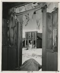 | Arizona, White Hills [01] | 1940; 1941; 1942; 1943; 1944; 1945; 1946; 1947; 1948; 1949; 1950; 1951; 1952; 1953; 1954; 1955; 1956; 1957; 1958; 1959; 1960; 1961; 1962; 1963; 1964; 1965; 1966; 1967; 1968; 1969; 1970 | Image | uum_map |
| 94 | 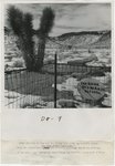 | Arizona, White Hills [02] | 1940; 1941; 1942; 1943; 1944; 1945; 1946; 1947; 1948; 1949; 1950; 1951; 1952; 1953; 1954; 1955; 1956; 1957; 1958; 1959; 1960; 1961; 1962; 1963; 1964; 1965; 1966; 1967; 1968; 1969; 1970 | Image | uum_map |
| 95 |  | Arizona, White Hills [03] | 1940; 1941; 1942; 1943; 1944; 1945; 1946; 1947; 1948; 1949; 1950; 1951; 1952; 1953; 1954; 1955; 1956; 1957; 1958; 1959; 1960; 1961; 1962; 1963; 1964; 1965; 1966; 1967; 1968; 1969; 1970 | Image | uum_map |
| 96 | 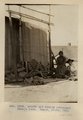 | Arnold and family (Chinlee) Navajo loom. Heald, photo, 1911 (Photo G282) | 1911 | Image | uum_map |
| 97 | 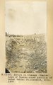 | Arroyo in Cienega (meadow), line of bushes shows position of water table, St. Michaels, Ariz., 1909 (photo G-3) | 1909 | Image | uum_map |
| 98 | 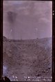 | Arroyo in cienega, St. Michaels, Ariz. (negative for G-3) | 1909 | Image | uum_map |
| 99 | 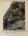 | Ash and tuff near Biddehoche. VI, 84 (Photo G231) | 1911 | Image | uum_map |
| 100 | 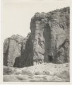 | Ash, Twin Buttes (Photo G252) | 1911 | Image | uum_map |