Home
Browse
Ask Us
Chat
Harmful Language Statement
Log in
Advanced Search
Year
1864
1865
1866
1867
1868
1869
1870
1871
1872
1873
1874
1875
1876
1877
1878
1879
1880
1881
1882
1883
1884
1885
1886
1887
1888
1889
1890
1891
1892
1893
1894
1895
1896
1897
1898
1899
1900
1901
1902
1903
1904
1905
1906
1907
1908
1909
1910
1911
1912
1913
1914
1915
1916
1917
1918
1919
1920
1921
1922
1923
1924
1925
1926
1927
1928
1929
1930
1931
1932
1933
1934
1935
1936
1937
1938
1939
1940
1941
1942
1943
1944
1945
1946
1947
1948
1949
1950
1951
1952
1953
1954
1955
1956
1957
1958
1959
1960
1961
1962
1963
1964
1965
1966
1967
1968
1969
1970
1971
1972
1973
1974
1975
1976
1977
1978
1979
1980
1981
1982
1983
1984
1985
1986
1987
1988
1989
1990
1991
1992
1993
1994
1995
1996
1997
1998
1999
2000
2001
2002
2003
2004
2005
TO
1864
1865
1866
1867
1868
1869
1870
1871
1872
1873
1874
1875
1876
1877
1878
1879
1880
1881
1882
1883
1884
1885
1886
1887
1888
1889
1890
1891
1892
1893
1894
1895
1896
1897
1898
1899
1900
1901
1902
1903
1904
1905
1906
1907
1908
1909
1910
1911
1912
1913
1914
1915
1916
1917
1918
1919
1920
1921
1922
1923
1924
1925
1926
1927
1928
1929
1930
1931
1932
1933
1934
1935
1936
1937
1938
1939
1940
1941
1942
1943
1944
1945
1946
1947
1948
1949
1950
1951
1952
1953
1954
1955
1956
1957
1958
1959
1960
1961
1962
1963
1964
1965
1966
1967
1968
1969
1970
1971
1972
1973
1974
1975
1976
1977
1978
1979
1980
1981
1982
1983
1984
1985
1986
1987
1988
1989
1990
1991
1992
1993
1994
1995
1996
1997
1998
1999
2000
2001
2002
2003
2004
2005
Type
Image
2,504
Text
2
Format
image/jpeg
2,384
application/pdf
118
Collection
American Westward Migration
1
Beckwith Photograph Collection
6
Classified Photographs
285
Photo Archives
1,767
Shipler Commercial Photographers
2
Utah River Running Photo Archives
440
Vernal Express Photographs
1
Western Waters Electronic Resources
2
More
Filters:
Spatial Coverage:
"Arizona"
Type:
"Image"
2451
-
2475
of
2,504
<
92
93
94
95
96
97
98
99
100
101
>
Gallery view
Number of results to display per page
10
25
50
100
200
Sort by Relevance
Sort by Title A-Z
Sort by Title Z-A
Sort by Date Ascending
Sort by Date Descending
Sort by Last Modified Ascending
Sort by Last Modified Descending
Title
Date
Type
Setname
2451
Webo Spgs., water from Mesa Verde sandstones (negative for photo G-97)
1909
Image
uum_map
2452
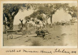
Well at mission house, Tolchaco, 1909
1909
Image
uum_map
2453
Well, Cottonwood Wash, below Wide Ruins. VII, 10 (Photo G266)
1911
Image
uum_map
2454
Wepo Spgs., Ariz., water from Mesa Verde sandstones at contact with shale, 1909 (photo G-97)
1909
Image
uum_map
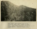
2455
West Kaibab fault at Oak Creek Mar, Ryan, AZ. Notch is fault plan. Basal Hermit brought to level of Middle Kaibab. Coconino County, AZ. 1922
1922
Image
uum_map
2456
Wetherals, Kayenta, 1926
1926
Image
uum_map_rr
2457
Wetherill, John-Ranch P.1
Image
dha_cp
2458
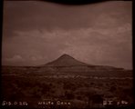
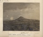
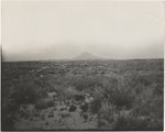
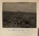
White Cone (Photo G256)
1911
Image
uum_map
2459
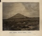
White Cone. 1911 (Photo G256)
1911
Image
uum_map
2460
White Cone. 1911 (Photo G257)
1911
Image
uum_map
2461
White Cone. 1911 (Photo G257)
1911
Image
uum_map
2462
White Cone. 1911 (Photo G258)
1911
Image
uum_map
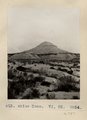
2463
White Cone. VI, 85 (Photo G254)
1911
Image
uum_map
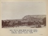
2464
White Mesa with natural arch, 40+ mi. north east of Tuba, Ariz. (Stephen Janus photo), 1909
1909
Image
uum_map
2465
White tailed squirrel at Jacob lake, Arizona in Kaibab National forest
1944; 1945; 1946
Image
uum_map
2466
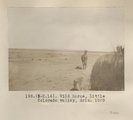
Wild horse, Little Colorado Valley, Ariz. 1909
1909
Image
uum_map
2467
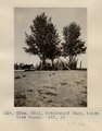
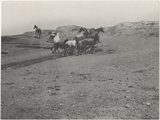
Wild horses, Little Colorado Valley, Ariz. 1909
1909
Image
uum_map
2468
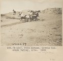
Wild horses, Little Colorado Valley, Ariz. 1909
1909
Image
uum_map
2469
William F. Cody, "Buffalo Bill"
Image
dha_cp
2470
William F. Cody, "Buffalo Bill"
Image
dha_cp
2471
Willow Springs, Echo Cliffs, 1900
1900
Image
uum_map
2472
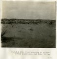
Wind beveling of cross-bedded sandstone, Red Lake Valley
1913
Image
uum_map
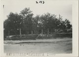
2473
Wind carving Kaibab 2 mi. above Tolchaco (Photo G414)
1913
Image
uum_map
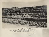
2474
Wind carving Kaibab 2 mi. above Tolchaco (Photo G414)
1913
Image
uum_map
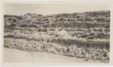
2475
Wind carving, Permian, 2 mi. above Tolchaco (Photo G412)
1913
Image
uum_map
2451
-
2475
of
2,504
<
92
93
94
95
96
97
98
99
100
101
>