Home
Browse
Ask Us
Chat
Harmful Language Statement
Log in
Advanced Search
Year
1864
1865
1866
1867
1868
1869
1870
1871
1872
1873
1874
1875
1876
1877
1878
1879
1880
1881
1882
1883
1884
1885
1886
1887
1888
1889
1890
1891
1892
1893
1894
1895
1896
1897
1898
1899
1900
1901
1902
1903
1904
1905
1906
1907
1908
1909
1910
1911
1912
1913
1914
1915
1916
1917
1918
1919
1920
1921
1922
1923
1924
1925
1926
1927
1928
1929
1930
1931
1932
1933
1934
1935
1936
1937
1938
1939
1940
1941
1942
1943
1944
1945
1946
1947
1948
1949
1950
1951
1952
1953
1954
1955
1956
1957
1958
1959
1960
1961
1962
1963
1964
1965
1966
1967
1968
1969
1970
1971
1972
1973
1974
1975
1976
1977
1978
1979
1980
1981
1982
1983
1984
1985
1986
1987
1988
1989
1990
1991
1992
1993
1994
1995
1996
1997
1998
1999
2000
2001
2002
2003
2004
2005
TO
1864
1865
1866
1867
1868
1869
1870
1871
1872
1873
1874
1875
1876
1877
1878
1879
1880
1881
1882
1883
1884
1885
1886
1887
1888
1889
1890
1891
1892
1893
1894
1895
1896
1897
1898
1899
1900
1901
1902
1903
1904
1905
1906
1907
1908
1909
1910
1911
1912
1913
1914
1915
1916
1917
1918
1919
1920
1921
1922
1923
1924
1925
1926
1927
1928
1929
1930
1931
1932
1933
1934
1935
1936
1937
1938
1939
1940
1941
1942
1943
1944
1945
1946
1947
1948
1949
1950
1951
1952
1953
1954
1955
1956
1957
1958
1959
1960
1961
1962
1963
1964
1965
1966
1967
1968
1969
1970
1971
1972
1973
1974
1975
1976
1977
1978
1979
1980
1981
1982
1983
1984
1985
1986
1987
1988
1989
1990
1991
1992
1993
1994
1995
1996
1997
1998
1999
2000
2001
2002
2003
2004
2005
Type
Image
2,504
Text
2
Format
image/jpeg
2,384
application/pdf
118
Collection
American Westward Migration
1
Beckwith Photograph Collection
6
Classified Photographs
285
Photo Archives
1,767
Shipler Commercial Photographers
2
Utah River Running Photo Archives
440
Vernal Express Photographs
1
Western Waters Electronic Resources
2
More
Filters:
Spatial Coverage:
"Arizona"
Type:
"Image"
2376
-
2400
of
2,504
<
91
92
93
94
95
96
97
98
99
100
>
Gallery view
Number of results to display per page
10
25
50
100
200
Sort by Relevance
Sort by Title A-Z
Sort by Title Z-A
Sort by Date Ascending
Sort by Date Descending
Sort by Last Modified Ascending
Sort by Last Modified Descending
Title
Date
Type
Setname
2376
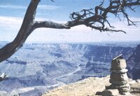
View in the Grand Canyon.
1970-04; 1970-05
Image
uum_map_rr
2377
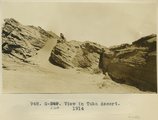
View in Tuba desert, 1914
1914
Image
uum_map
2378
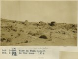
View in Tuba desert, 1914
1914
Image
uum_map
2379
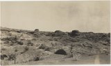
View in Tuba desert, 1914
1914
Image
uum_map
2380
View looking N.40 degrees W. up Paria River, Arizona, from top of Shinarump, south side of Colorado at Lees Ferry, Coconino County, Arizona. June 5, 1915.
1915
Image
uum_map
2381
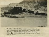
View looking north across Colorado at Lees Ferry along Echo Monocline, Coconino County, Arizona. Strata beginning at base: Moenkopi, Shinarump, Chinle, LaPlata. Paria River at left, June 6, 1915.
1915
Image
uum_map
2382
View looking S 75° W from junction of branches of Tees-Nos-Pos Canyon. White is Wingate overlain by Zuni and capped by Monzonite
1913
Image
uum_map
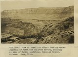
2383
View looking S.50 degrees W, from south side Colorado at head of Marble Canyon, Coconino County. Vermilion cliffs in right background. June 6, 1915.
1915
Image
uum_map
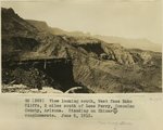
2384
View looking south along face of Echo Cliffs, 2 miles south of Lees Ferry, Coconino County, Arizona. Standing on Shinarump conglomerate. June 6, 1915.
1915
Image
uum_map
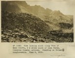
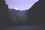
2385
View looking south along face of Echo Cliffs, 2+ miles south of Lees Ferry, Coconino County, Arizona. Standing on Shinarump conglomerate. June 6, 1915.
1915
Image
uum_map
2386
View looking west toward Canaan Gap of Short Creek. Road on Arizona-Utah line; foreground, flat cut in lowest Chinle beds; background, cliffs and ridges of eastward dipping Shinarump overlying Moenkopi. Washington County, Utah, 1937.
1937
Image
uum_map
2387
View north from Vulcan's Throne
1900
Image
uum_map
2388
View northward over Moccasin Springs along Sevier fault. Navajo (left) and Chinle (right), on skyline. 1939. Deep alluvium trenched by stream from springs (foreground)
1939
Image
uum_map
2389
View of Grand Canyon from South Rim, Nevills Expedition Grand Canyon river trip, 1942 [2]
1942
Image
uum_map_rr
2390
View of Grand Canyon from South Rim, Nevills Expedition Grand Canyon river trip, 1942 [3]
1942
Image
uum_map_rr
2391
View of Grand Canyon from South Rim, Nevills Expedition Grand Canyon river trip, 1942 [4]
1942
Image
uum_map_rr
2392
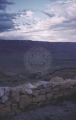
View of House Rock Valley from Kaibab Plateau, on the road to Lees Ferry to start a boating trip through the Grand Canyon.
1960
Image
uum_map
2393
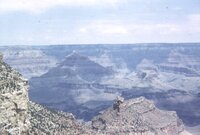
View of the Grand Canyon.
1960
Image
uum_map
2394
View of the Grand Canyon.
1960
Image
uum_map
2395
View of Vermilion cliffs looking across junction of Paria and Colorado rivers, standing at base of Navajo sandstone, Coconino County, Arizona. June, 1915.
1915
Image
uum_map
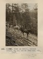
2396
View on trail, Spruce Brook, 5+ mi. above Tsa-lee. VII, 1911 (Photo G-290)
1911
Image
uum_map
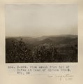
2397
View south from top of Butte at head of Spruce Brook. VII, 52 (Photo G-289)
1911
Image
uum_map
2398
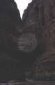
View while boating in the Grand Canyon.
1960
Image
uum_map
2399
View while boating in the Grand Canyon.
1960
Image
uum_map
2400
View while boating in the Grand Canyon.
1960
Image
uum_map
2376
-
2400
of
2,504
<
91
92
93
94
95
96
97
98
99
100
>