Home
Browse
Ask Us
Chat
Harmful Language Statement
Log in
Advanced Search
Year
1864
1865
1866
1867
1868
1869
1870
1871
1872
1873
1874
1875
1876
1877
1878
1879
1880
1881
1882
1883
1884
1885
1886
1887
1888
1889
1890
1891
1892
1893
1894
1895
1896
1897
1898
1899
1900
1901
1902
1903
1904
1905
1906
1907
1908
1909
1910
1911
1912
1913
1914
1915
1916
1917
1918
1919
1920
1921
1922
1923
1924
1925
1926
1927
1928
1929
1930
1931
1932
1933
1934
1935
1936
1937
1938
1939
1940
1941
1942
1943
1944
1945
1946
1947
1948
1949
1950
1951
1952
1953
1954
1955
1956
1957
1958
1959
1960
1961
1962
1963
1964
1965
1966
1967
1968
1969
1970
1971
1972
1973
1974
1975
1976
1977
1978
1979
1980
1981
1982
1983
1984
1985
1986
1987
1988
1989
1990
1991
1992
1993
1994
1995
1996
1997
1998
1999
2000
2001
2002
2003
2004
2005
TO
1864
1865
1866
1867
1868
1869
1870
1871
1872
1873
1874
1875
1876
1877
1878
1879
1880
1881
1882
1883
1884
1885
1886
1887
1888
1889
1890
1891
1892
1893
1894
1895
1896
1897
1898
1899
1900
1901
1902
1903
1904
1905
1906
1907
1908
1909
1910
1911
1912
1913
1914
1915
1916
1917
1918
1919
1920
1921
1922
1923
1924
1925
1926
1927
1928
1929
1930
1931
1932
1933
1934
1935
1936
1937
1938
1939
1940
1941
1942
1943
1944
1945
1946
1947
1948
1949
1950
1951
1952
1953
1954
1955
1956
1957
1958
1959
1960
1961
1962
1963
1964
1965
1966
1967
1968
1969
1970
1971
1972
1973
1974
1975
1976
1977
1978
1979
1980
1981
1982
1983
1984
1985
1986
1987
1988
1989
1990
1991
1992
1993
1994
1995
1996
1997
1998
1999
2000
2001
2002
2003
2004
2005
Type
Image
2,504
Text
2
Format
image/jpeg
2,384
application/pdf
118
Collection
American Westward Migration
1
Beckwith Photograph Collection
6
Classified Photographs
285
Photo Archives
1,767
Shipler Commercial Photographers
2
Utah River Running Photo Archives
440
Vernal Express Photographs
1
Western Waters Electronic Resources
2
More
Filters:
Spatial Coverage:
"Arizona"
Type:
"Image"
2301
-
2325
of
2,504
<
88
89
90
91
92
93
94
95
96
97
>
Gallery view
Number of results to display per page
10
25
50
100
200
Sort by Relevance
Sort by Title A-Z
Sort by Title Z-A
Sort by Date Ascending
Sort by Date Descending
Sort by Last Modified Ascending
Sort by Last Modified Descending
Title
Date
Type
Setname
2301
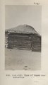
Type of Hogan construction (Photo N-M150)
1913
Image
uum_map
2302
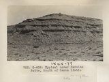
Typical Lower Permian Butte, Mouth of Canon Diablo (Photo G408)
1913
Image
uum_map
2303
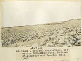
Typical vegetation, elevation 5000-5500 feet, between St. Michaels and Ganado, Ariz., 1909 (photo G-34)
1909
Image
uum_map
2304
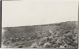
Typical vegetation, elevation 5000-5500 feet, between St. Michaels and Ganado, Ariz., 1909 (photo G-34)
1909
Image
uum_map
2305
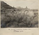
Typical vegetation, Monument Pass, Utah. S. M. Young, photo.
1909
Image
uum_map
2306
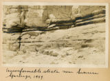
Unconformable strata near Sunrise Springs, 1909
1909
Image
uum_map
2307
Unconformity (indicated by hammer) between quartzite (pre-Cambrian) and Moencopie shales (Permian?), "Blue Canyon," 2± mil. northwest of Fort Defiance, Ariz., 1909 (photo G-4)
1909
Image
uum_map
2308
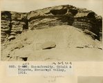
Unconformity, Chinli & Wingate, Moencopi valley, 1914
1914
Image
uum_map
2309
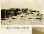
Unconformity, Chinli and Wingate, 1914, Moenkopi Valley
1914
Image
uum_map
2310
Unconformity, Dakota on McElmo, 1± mi. south of Steamboat in Steamboat canyon. VII, 7 (Photo G261)
1911
Image
uum_map
2311
Unconformity, McElmo (?) on La Plata (?) or in 2± mil. southwest of Sunrise Spgs., Arizona (photo G-43)
1909
Image
uum_map
2312
Unconformity, McElmo (?) on La Plata (?) or in 2± mil. southwest of Sunrise Spgs., Arizona (photo G-43)
1909
Image
uum_map
2313
Unconformity, Moencopie-Shinarump, 1 mi. below bridge, Little Colorado (Photo G427)
1913
Image
uum_map
2314
Unconformity, Permian-Shinarump. Fort Defiance (Photo G322)
1913
Image
uum_map
2315
Unconformity, quartzite (pre-Cambrian?) and Moencopie shale (Permian?) at "Blue Canyon," 2± mil. northwest of Fort Defiance, Ariz., 1909 (photo G-5)
1909
Image
uum_map
2316
Unconformity, Shinarump on Moencopie, Ft. Defiance. 1911 (Photo N-M107)
1911
Image
uum_map
2317
Unconformity, Shinarump on Moencopie, Nazlini canyon, 3± mi. below store. VII, 23 (Photo G270)
1911
Image
uum_map
2318
Unconformity. McElmo-Dakota. Blue Canon.
1913
Image
uum_map
2319
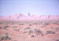
Unidentified desert scene with distant rock formations
1950; 1951; 1952; 1953; 1954; 1955; 1956; 1957; 1958; 1959; 1960; 1961; 1962; 1963; 1964; 1965; 1966; 1967; 1968; 1969; 1970; 1971; 1972; 1973; 1974; 1975; 1976; 1977; 1978; 1979; 1980
Image
uum_map_rr
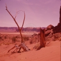
2320
Unidentified granaries.
1950; 1951; 1952; 1953; 1954; 1955; 1956; 1957; 1958; 1959; 1960
Image
uum_map
2321
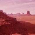
Unidentified landscape.
1956
Image
uum_map
2322
Unidentified landscape.
1950; 1951; 1952; 1953; 1954; 1955; 1956; 1957; 1958; 1959
Image
uum_map
2323
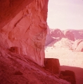
Unidentified southern Utah scenery
1937; 1938; 1939; 1940; 1941; 1942; 1943; 1944; 1945; 1946; 1947; 1948; 1949; 1950; 1951; 1952; 1953; 1954; 1955; 1956; 1957; 1958; 1959; 1960; 1961; 1962; 1963; 1964; 1965; 1966; 1967; 1968; 1969; 1970; 1971; 1972; 1973; 1974; 1975; 1976; 1977; 1978; 1979; 1980
Image
uum_map_rr
2324
Unidentified southern Utah scenery (depicts some form of volcanic activity such as cinder cones, lava flows, etc.) [1]
1950; 1951; 1952; 1953; 1954; 1955; 1956; 1957; 1958; 1959; 1960; 1961; 1962; 1963; 1964; 1965; 1966; 1967; 1968; 1969; 1970; 1971; 1972; 1973; 1974; 1975; 1976; 1977; 1978; 1979; 1980
Image
uum_map_rr
2325
Unidentified southern Utah scenery (depicts some form of volcanic activity such as cinder cones, lava flows, etc.) [2]
1950; 1951; 1952; 1953; 1954; 1955; 1956; 1957; 1958; 1959; 1960; 1961; 1962; 1963; 1964; 1965; 1966; 1967; 1968; 1969; 1970; 1971; 1972; 1973; 1974; 1975; 1976; 1977; 1978; 1979; 1980
Image
uum_map_rr
2301
-
2325
of
2,504
<
88
89
90
91
92
93
94
95
96
97
>