Home
Browse
Ask Us
Chat
Harmful Language Statement
Log in
Advanced Search
Year
1864
1865
1866
1867
1868
1869
1870
1871
1872
1873
1874
1875
1876
1877
1878
1879
1880
1881
1882
1883
1884
1885
1886
1887
1888
1889
1890
1891
1892
1893
1894
1895
1896
1897
1898
1899
1900
1901
1902
1903
1904
1905
1906
1907
1908
1909
1910
1911
1912
1913
1914
1915
1916
1917
1918
1919
1920
1921
1922
1923
1924
1925
1926
1927
1928
1929
1930
1931
1932
1933
1934
1935
1936
1937
1938
1939
1940
1941
1942
1943
1944
1945
1946
1947
1948
1949
1950
1951
1952
1953
1954
1955
1956
1957
1958
1959
1960
1961
1962
1963
1964
1965
1966
1967
1968
1969
1970
1971
1972
1973
1974
1975
1976
1977
1978
1979
1980
1981
1982
1983
1984
1985
1986
1987
1988
1989
1990
1991
1992
1993
1994
1995
1996
1997
1998
1999
2000
2001
2002
2003
2004
2005
TO
1864
1865
1866
1867
1868
1869
1870
1871
1872
1873
1874
1875
1876
1877
1878
1879
1880
1881
1882
1883
1884
1885
1886
1887
1888
1889
1890
1891
1892
1893
1894
1895
1896
1897
1898
1899
1900
1901
1902
1903
1904
1905
1906
1907
1908
1909
1910
1911
1912
1913
1914
1915
1916
1917
1918
1919
1920
1921
1922
1923
1924
1925
1926
1927
1928
1929
1930
1931
1932
1933
1934
1935
1936
1937
1938
1939
1940
1941
1942
1943
1944
1945
1946
1947
1948
1949
1950
1951
1952
1953
1954
1955
1956
1957
1958
1959
1960
1961
1962
1963
1964
1965
1966
1967
1968
1969
1970
1971
1972
1973
1974
1975
1976
1977
1978
1979
1980
1981
1982
1983
1984
1985
1986
1987
1988
1989
1990
1991
1992
1993
1994
1995
1996
1997
1998
1999
2000
2001
2002
2003
2004
2005
Type
Image
2,504
Text
2
Format
image/jpeg
2,384
application/pdf
118
Collection
American Westward Migration
1
Beckwith Photograph Collection
6
Classified Photographs
285
Photo Archives
1,767
Shipler Commercial Photographers
2
Utah River Running Photo Archives
440
Vernal Express Photographs
1
Western Waters Electronic Resources
2
More
Filters:
Spatial Coverage:
"Arizona"
Type:
"Image"
2251
-
2275
of
2,504
<
86
87
88
89
90
91
92
93
94
95
>
Gallery view
Number of results to display per page
10
25
50
100
200
Sort by Relevance
Sort by Title A-Z
Sort by Title Z-A
Sort by Date Ascending
Sort by Date Descending
Sort by Last Modified Ascending
Sort by Last Modified Descending
Title
Date
Type
Setname
2251
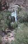
Thunder River falls in spring
1970-04; 1970-05
Image
uum_map_rr
2252
Timpoweap member of the Moenkopi formation. Kaibab at base, upstream. East rim of the Kaibab Plateau near the UT-AZ line. Coconino County, AZ, 1944
1944
Image
uum_map
2253
Top of Black Mesa at Onion Spgs., 12± mi. northeast of Oraibi, Ariz. (Mesa Verde strata), 1909 (photo G-95)
1909
Image
uum_map
2254
Top of Black Mesa, Onion Spgs. (Negative for photo G-95)
1909
Image
uum_map
2255
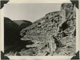
Top of Carrizo Mt. Dakota sandstone broken up by frost on ridge NE of Pastora Peak
1913
Image
uum_map
2256
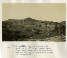
Top of Carrizo Mt. Looking N 30° E at Laden Peak from east base of Pastora Peak. Mature valley of Des-chee Creek in foreground
1913
Image
uum_map
2257
Top of Carrizo Mt. Looking S 30° W down south canyon
1913
Image
uum_map
2258
Top of Lukachukai Mts., looking at Roof Butte from the southwest
1913
Image
uum_map
2259
Top of plateau between St. Michaels and Ganado, Ariz. Trees are yellow pines, 1909 (photo G-33)
1909
Image
uum_map
2260
Top of plateau between St. Michaels and Ganado, Ariz. Trees are yellow pines, 1909 (photo G-33)
1909
Image
uum_map
2261
Top of plateau near Sawmill, 16± mi. northwest of Fort Defiance, Ariz. Trees are yellow pines and scrup oaks, 1909 (photo G-22)
1909
Image
uum_map
2262
Top of plateau near Sawmill, 16± mi. northwest of Fort Defiance, Ariz. Trees are yellow pines and scrup oaks, 1909 (photo G-22)
1909
Image
uum_map
2263
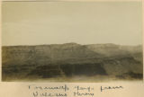
Toroweap Gorge from Vulcans Throne
1900
Image
uum_map
2264
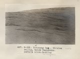
Totocong Spg., Chinlee valley, below Tsenakahn. LaPlata cross-bedding (Photo G331)
1913
Image
uum_map
2265
Totocong Spg., Chinlee valley, below Tsenakahn. LaPlata cross-bedding (Photo G331)
1913
Image
uum_map
2266
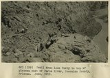
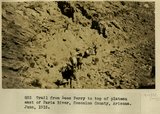
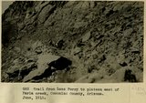
Trail from Lees Ferry to top of plateau east of Paria River, Coconino County, Arizona. June, 1915.
1915
Image
uum_map
2267
Trail from Lees Ferry to top of plateau east of Paria River, Coconino County, Arizona. June, 1915.
1915
Image
uum_map
2268
Trail from Lees Ferry to top of plateau east of Paria River, Coconino County, Arizona. June, 1915.
1915
Image
uum_map
2269
Trail up First Mesa. A. C. Vroman, photo
1909
Image
uum_map
2270
Trail up Oraibi Mesa, Arizona. H. F. Robinson, photo. 1909
1909
Image
uum_map
2271
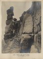
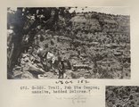
Trail, Pah Ute Canyon; massive, bedded Dolores (Photo G369)
1913
Image
uum_map
2272
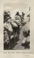
Trail, PahUte canyon (Photo N-M162)
1913
Image
uum_map
2273
Transmission wires (311-9)
1962; 1963; 1964; 1965; 1966
Image
uum_map_rr
2274
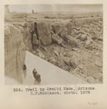
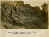
Trenched alluvial filling of Moenkopi valley, 8 mi. SW of Tuba, 1914
1914
Image
uum_map
2275
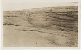
Trenched alluvium, Togusja Canyon, 1914
1914
Image
uum_map
2251
-
2275
of
2,504
<
86
87
88
89
90
91
92
93
94
95
>