Home
Browse
Ask Us
Chat
Harmful Language Statement
Log in
Advanced Search
Year
1864
1865
1866
1867
1868
1869
1870
1871
1872
1873
1874
1875
1876
1877
1878
1879
1880
1881
1882
1883
1884
1885
1886
1887
1888
1889
1890
1891
1892
1893
1894
1895
1896
1897
1898
1899
1900
1901
1902
1903
1904
1905
1906
1907
1908
1909
1910
1911
1912
1913
1914
1915
1916
1917
1918
1919
1920
1921
1922
1923
1924
1925
1926
1927
1928
1929
1930
1931
1932
1933
1934
1935
1936
1937
1938
1939
1940
1941
1942
1943
1944
1945
1946
1947
1948
1949
1950
1951
1952
1953
1954
1955
1956
1957
1958
1959
1960
1961
1962
1963
1964
1965
1966
1967
1968
1969
1970
1971
1972
1973
1974
1975
1976
1977
1978
1979
1980
1981
1982
1983
1984
1985
1986
1987
1988
1989
1990
1991
1992
1993
1994
1995
1996
1997
1998
1999
2000
2001
2002
2003
2004
2005
TO
1864
1865
1866
1867
1868
1869
1870
1871
1872
1873
1874
1875
1876
1877
1878
1879
1880
1881
1882
1883
1884
1885
1886
1887
1888
1889
1890
1891
1892
1893
1894
1895
1896
1897
1898
1899
1900
1901
1902
1903
1904
1905
1906
1907
1908
1909
1910
1911
1912
1913
1914
1915
1916
1917
1918
1919
1920
1921
1922
1923
1924
1925
1926
1927
1928
1929
1930
1931
1932
1933
1934
1935
1936
1937
1938
1939
1940
1941
1942
1943
1944
1945
1946
1947
1948
1949
1950
1951
1952
1953
1954
1955
1956
1957
1958
1959
1960
1961
1962
1963
1964
1965
1966
1967
1968
1969
1970
1971
1972
1973
1974
1975
1976
1977
1978
1979
1980
1981
1982
1983
1984
1985
1986
1987
1988
1989
1990
1991
1992
1993
1994
1995
1996
1997
1998
1999
2000
2001
2002
2003
2004
2005
Type
Image
2,504
Text
2
Format
image/jpeg
2,384
application/pdf
118
Collection
American Westward Migration
1
Beckwith Photograph Collection
6
Classified Photographs
285
Photo Archives
1,767
Shipler Commercial Photographers
2
Utah River Running Photo Archives
440
Vernal Express Photographs
1
Western Waters Electronic Resources
2
More
Filters:
Spatial Coverage:
"Arizona"
Type:
"Image"
2201
-
2225
of
2,504
<
84
85
86
87
88
89
90
91
92
93
>
Gallery view
Number of results to display per page
10
25
50
100
200
Sort by Relevance
Sort by Title A-Z
Sort by Title Z-A
Sort by Date Ascending
Sort by Date Descending
Sort by Last Modified Ascending
Sort by Last Modified Descending
Title
Date
Type
Setname
2201
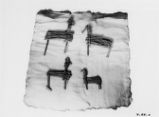
Stick Figures p.1
Image
dha_cp
2202
Stiles' Ranch, Moqui Buttes, Ariz. 1909
1909
Image
uum_map
2203
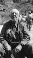
Stone Expedition, 1909 P.1
1909
Image
dha_cp
2204
Stone Expedition, 1909 P.2
1909
Image
dha_cp
2205
Stone Expedition, 1909 P.3
1909
Image
dha_cp
2206
Stone Expedition, 1938 P.1
1938
Image
dha_cp
2207
Stone Expedition, 1938 P.2
1938
Image
dha_cp
2208
Stone Expedition, 1938 P.3
1938
Image
dha_cp
2209
Stone Expedition, 1938 P.4
1938
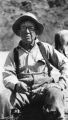
Image
dha_cp
2210
Stone Expedition, 1938 P.5
1938
Image
dha_cp
2211
Stone Expedition, 1938 P.6
1938
Image
dha_cp
2212
Stone Expedition, 1938 P.7
1938
Image
dha_cp
2213
Stone Expedition, 1938 P.8
1938-10-06
Image
dha_cp
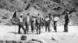
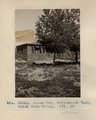
2214
Stone Hut, Cottonwood Wash, below Wide Ruins. VII, 10 (Photo G265A)
1911
Image
uum_map
2215
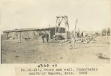
Store and well, Cornfields south of Ganado, Ariz., 1909 (sheet G-61)
1909
Image
uum_map
2216
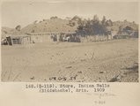
Store, Indian Wells (Biddehoche), Ariz. 1909
1909
Image
uum_map
2217
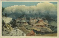
Storm in Grand Canyon
1930; 1931; 1932; 1933; 1934; 1935; 1936; 1937; 1938; 1939; 1940; 1941; 1942; 1943; 1944; 1945
Image
uum_map
2218
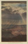
Storm in the canyon: Grand Canyon National Park, Arizona
1930; 1931; 1932; 1933; 1934; 1935; 1936; 1937; 1938; 1939; 1940; 1941; 1942; 1943; 1944; 1945
Image
uum_map
2219
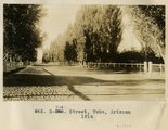
Street, Tuba, Arizona, 1914
1914
Image
uum_map
2220
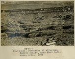
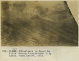
Structure of alluvium, Canyon Bonito, near Fort Defiance, Ariz., 1909 (photo G-10)
1909
Image
uum_map
2221
Structure of alluvium, Canyon Bonito, near Fort Defiance, Ariz., 1909 (photo G-10)
1909
Image
uum_map
2222
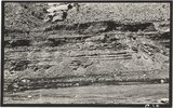
Structures in Upper La Plata (Navajo) sandstone, City Rocks, Tuba desert, 1914
1914
Image
uum_map
2223
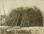
Summer hogan, Navajo Indians
1915
Image
uum_map
2224
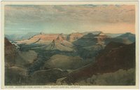
Sunrise from Hermit Trail, Grand Canyon, Arizona
1910; 1911; 1912; 1913; 1914; 1915; 1916; 1917; 1918; 1919; 1920; 1921; 1922; 1923; 1924; 1925; 1926; 1927; 1928; 1929; 1930; 1931; 1932; 1933; 1934; 1935
Image
uum_map
2225
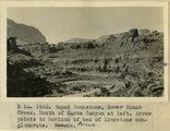
Supai Sandstone, lower Kanab Creek. Mouth of Karks Canyon at left. Arrow points to horizon of bed of limestone conglomerate. AZ
1922
Image
uum_map
2201
-
2225
of
2,504
<
84
85
86
87
88
89
90
91
92
93
>