Home
Browse
Ask Us
Chat
Harmful Language Statement
Log in
Advanced Search
Year
1864
1865
1866
1867
1868
1869
1870
1871
1872
1873
1874
1875
1876
1877
1878
1879
1880
1881
1882
1883
1884
1885
1886
1887
1888
1889
1890
1891
1892
1893
1894
1895
1896
1897
1898
1899
1900
1901
1902
1903
1904
1905
1906
1907
1908
1909
1910
1911
1912
1913
1914
1915
1916
1917
1918
1919
1920
1921
1922
1923
1924
1925
1926
1927
1928
1929
1930
1931
1932
1933
1934
1935
1936
1937
1938
1939
1940
1941
1942
1943
1944
1945
1946
1947
1948
1949
1950
1951
1952
1953
1954
1955
1956
1957
1958
1959
1960
1961
1962
1963
1964
1965
1966
1967
1968
1969
1970
1971
1972
1973
1974
1975
1976
1977
1978
1979
1980
1981
1982
1983
1984
1985
1986
1987
1988
1989
1990
1991
1992
1993
1994
1995
1996
1997
1998
1999
2000
2001
2002
2003
2004
2005
TO
1864
1865
1866
1867
1868
1869
1870
1871
1872
1873
1874
1875
1876
1877
1878
1879
1880
1881
1882
1883
1884
1885
1886
1887
1888
1889
1890
1891
1892
1893
1894
1895
1896
1897
1898
1899
1900
1901
1902
1903
1904
1905
1906
1907
1908
1909
1910
1911
1912
1913
1914
1915
1916
1917
1918
1919
1920
1921
1922
1923
1924
1925
1926
1927
1928
1929
1930
1931
1932
1933
1934
1935
1936
1937
1938
1939
1940
1941
1942
1943
1944
1945
1946
1947
1948
1949
1950
1951
1952
1953
1954
1955
1956
1957
1958
1959
1960
1961
1962
1963
1964
1965
1966
1967
1968
1969
1970
1971
1972
1973
1974
1975
1976
1977
1978
1979
1980
1981
1982
1983
1984
1985
1986
1987
1988
1989
1990
1991
1992
1993
1994
1995
1996
1997
1998
1999
2000
2001
2002
2003
2004
2005
Type
Image
2,504
Text
2
Format
image/jpeg
2,384
application/pdf
118
Collection
American Westward Migration
1
Beckwith Photograph Collection
6
Classified Photographs
285
Photo Archives
1,767
Shipler Commercial Photographers
2
Utah River Running Photo Archives
440
Vernal Express Photographs
1
Western Waters Electronic Resources
2
More
Filters:
Spatial Coverage:
"Arizona"
Type:
"Image"
1876
-
1900
of
2,504
<
71
72
73
74
75
76
77
78
79
80
>
Gallery view
Number of results to display per page
10
25
50
100
200
Sort by Relevance
Sort by Title A-Z
Sort by Title Z-A
Sort by Date Ascending
Sort by Date Descending
Sort by Last Modified Ascending
Sort by Last Modified Descending
Title
Date
Type
Setname
1876
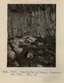
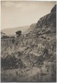
Quartzite columns, Lukachukai Mts. VII, 50 (Photo G288)
1911
Image
uum_map
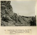
1877
Quartzite, Blue Canyon, 2± miles northwest of Fort Defiance, Ariz., M.R. Campbell, photo, U.S.G.S. 6
1909
Image
uum_map
1878
Radio Antenna at Short Creek
1953
Image
dha_cp
1879
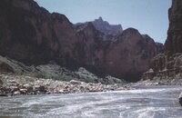
Raft in Hance rapid
1966-05
Image
uum_map_rr
1880
Rain
1971-08
Image
uum_map_rr
1881
Ralph & Vincent Pace
1965-06
Image
uum_map_rr
1882
Ralph [cracked?] lower unit
1965-06
Image
uum_map_rr
1883
Rapid 205 [strikeover says Rapid 217; not sure of location], Ralph Peterson with 1 motor
1965-06
Image
uum_map_rr
1884
Rapid 205, Ralph Peterson
1965-06
Image
uum_map_rr
1885
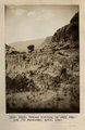
Recemented volcanic conglomerate; near "Black Rock" between Sunrise Springs and Biddehoche (Indian Wells), Ariz., 1909 (photo G-47)
1909
Image
uum_map
1886
Recent cutting in Sagy Canyon (Towanaoche) Ariz., 1910 (Photo G163)
1910
Image
uum_map
1887
Recent cutting in Sagy Canyon (Towanaoche) Ariz., 1910 (Photo G163)
1910
Image
uum_map
1888
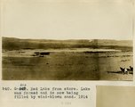
Red Lake from store. Lake was formed and is now being filled by wind-blown sand, 1914
1914
Image
uum_map
1889
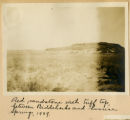
Red sandstone with tuff top, between Biddehoche and Sunrise Springs, 1909
1909
Image
uum_map
1890
Redwall Limestone wall near Eminence Break, mile 45, Grand Canyon.
1968; 1969; 1970; 1971; 1972; 1973
Image
uum_map_rr
1891
Reservoir Canyon, Tuba, Ariz., 1910 (Photo G188)
1910
Image
uum_map
1892
Restaurant in motel at Wahweap (311-12)
1962; 1963; 1964; 1965; 1966
Image
uum_map_rr
1893
Ripple marks and mud cracks. At LaPlata-Dolores contact 6 mi. east of Tanners Crossing.
1913
Image
uum_map
1894
Ripple marks near Leupp. E.C.Case, photo
1913
Image
uum_map
1895
Ripple marks, Permian, mouth of Canon Diablo (also IV-3) (Photo G407)
1913
Image
uum_map
1896
Road among cinder cones, Sunset Crater National Monument
1930; 1931; 1932; 1933; 1934; 1935; 1936; 1937; 1938; 1939; 1940; 1941; 1942; 1943; 1944; 1945; 1946; 1947; 1948; 1949; 1950
Image
uum_map_rr
1897
Road out of Little Colorado, Tanners Crossing 1900
1900
Image
uum_map
1898
Rock floor, La Plata, north of Tuba
1913
Image
uum_map
1899
Rock floor, La Plata, north of Tuba
1913
Image
uum_map
1900
Rock formations, Arizona
1945; 1946; 1947; 1948; 1949; 1950; 1951; 1952; 1953; 1954; 1955; 1956; 1957; 1958; 1959; 1960; 1961; 1962; 1963; 1964; 1965
Image
uum_map
1876
-
1900
of
2,504
<
71
72
73
74
75
76
77
78
79
80
>