Home
Browse
Ask Us
Chat
Harmful Language Statement
Log in
Advanced Search
Year
1864
1865
1866
1867
1868
1869
1870
1871
1872
1873
1874
1875
1876
1877
1878
1879
1880
1881
1882
1883
1884
1885
1886
1887
1888
1889
1890
1891
1892
1893
1894
1895
1896
1897
1898
1899
1900
1901
1902
1903
1904
1905
1906
1907
1908
1909
1910
1911
1912
1913
1914
1915
1916
1917
1918
1919
1920
1921
1922
1923
1924
1925
1926
1927
1928
1929
1930
1931
1932
1933
1934
1935
1936
1937
1938
1939
1940
1941
1942
1943
1944
1945
1946
1947
1948
1949
1950
1951
1952
1953
1954
1955
1956
1957
1958
1959
1960
1961
1962
1963
1964
1965
1966
1967
1968
1969
1970
1971
1972
1973
1974
1975
1976
1977
1978
1979
1980
1981
1982
1983
1984
1985
1986
1987
1988
1989
1990
1991
1992
1993
1994
1995
1996
1997
1998
1999
2000
2001
2002
2003
2004
2005
TO
1864
1865
1866
1867
1868
1869
1870
1871
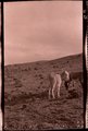
1872
1873
1874
1875
1876
1877
1878
1879
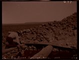
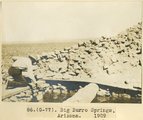
1880
1881
1882
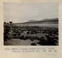
1883
1884
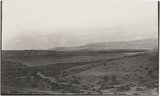
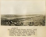
1885
1886
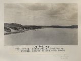
1887
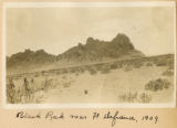
1888
1889
1890
1891
1892
1893
1894
1895
1896
1897
1898
1899
1900
1901
1902
1903
1904
1905
1906
1907
1908
1909
1910
1911
1912
1913
1914
1915
1916
1917
1918
1919
1920
1921
1922
1923
1924
1925
1926
1927
1928
1929
1930
1931
1932
1933
1934
1935
1936
1937
1938
1939
1940
1941
1942
1943
1944
1945
1946
1947
1948
1949
1950
1951
1952
1953
1954
1955
1956
1957
1958
1959
1960
1961
1962
1963
1964
1965
1966
1967
1968
1969
1970
1971
1972
1973
1974
1975
1976
1977
1978
1979
1980
1981
1982
1983
1984
1985
1986
1987
1988
1989
1990
1991
1992
1993
1994
1995
1996
1997
1998
1999
2000
2001
2002
2003
2004
2005
Type
Image
2,504
Text
2
Format
image/jpeg
2,384
application/pdf
118
Institution
University of Utah Marriott Library
2,207
Department of Cultural and Community ...
287
Delta City Library
6
Western Waters Digital Library
2
Uintah County Library
1
University of Utah Partnerships
1
More
Collection
American Westward Migration
1
Beckwith Photograph Collection
6
Classified Photographs
285
Photo Archives
1,767
Shipler Commercial Photographers
2
Utah River Running Photo Archives
440
Vernal Express Photographs
1
Western Waters Electronic Resources
2
More
Filters:
Spatial Coverage:
"Arizona"
Type:
"Image"
151
-
175
of
2,504
<
2
3
4
5
6
7
8
9
10
11
>
Gallery view
Number of results to display per page
10
25
50
100
200
Sort by Relevance
Sort by Title A-Z
Sort by Title Z-A
Sort by Date Ascending
Sort by Date Descending
Sort by Last Modified Ascending
Sort by Last Modified Descending
Title
Date
Type
Setname
151
Below Lava Falls
1965-06
Image
uum_map_rr
152
Below Little Colorado
1970-04; 1970-05
Image
uum_map_rr
153
Below Little Colorado
1970-04; 1970-05
Image
uum_map_rr
154
Below Phantom [ranch] and above Bass
1971-05-09
Image
uum_map_rr
155
Below Phantom Ranch after rain
1965-06
Image
uum_map_rr
156
Bernheimer Bridge
1925; 1926; 1927; 1928; 1929; 1930; 1931; 1932; 1933; 1934; 1935; 1936; 1937; 1938; 1939; 1940; 1941; 1942; 1943; 1944; 1945; 1946; 1947; 1948; 1949
Image
uum_map_rr
157
Bernheimer Bridge
1925; 1926; 1927; 1928; 1929; 1930; 1931; 1932; 1933; 1934; 1935; 1936; 1937; 1938; 1939; 1940; 1941; 1942; 1943; 1944; 1945; 1946; 1947; 1948; 1949
Image
uum_map_rr
158
Bernheimer Bridge
1925; 1926; 1927; 1928; 1929; 1930; 1931; 1932; 1933; 1934; 1935; 1936; 1937; 1938; 1939; 1940; 1941; 1942; 1943; 1944; 1945; 1946; 1947; 1948; 1949
Image
uum_map_rr
159
Beryl on Snowball, at V.K. ranch, April 1936
1936-04
Image
uum_map
160
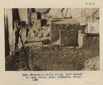
Betatakin cliff ruins, west branch of Sagy canon, Ariz., (Townsend photo, 1909)
1909
Image
uum_map
161
Betatakin Ruin P.1
Image
dha_cp
162
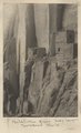
Betatakin Ruin, Sagy Canyon (Townsend photo)
1910
Image
uum_map
163
Between Phantom [ranch] and Bass
1971-05-09
Image
uum_map_rr
164
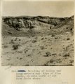
Beveling and conglomerate cap of lower peneplain, north side Blue Canon, opposite old store.
1913
Image
uum_map
165
Beveling below Black Falls, looking north.
1913
Image
uum_map
166
Beveling of McElmo and conglomerate cap. Edge of Blue Canon, 1 1/2 mile north of old Blue Canon store.
1913
Image
uum_map
167
Big Burro Springs, Arizona, 1909 (negative for photo G-77)
1909
Image
uum_map
168
Big Burro Springs, Arizona, 1909 (photo G-77)
1909
Image
uum_map
169
Bit of Grand Canyon cornice work
1920; 1921; 1922; 1923; 1924; 1925; 1926; 1927; 1928; 1929; 1930; 1931; 1932; 1933; 1934; 1935; 1936; 1937; 1938; 1939; 1940; 1941; 1942; 1943; 1944; 1945; 1946; 1947; 1948; 1949; 1950
Image
uum_map
170
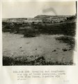
Black Creek Valley, Arizona (negative for photo G-11)
1909
Image
uum_map
171
Black Creek valley, east toward Baigaiche Mt. VI, 45, 55 (Photo G299)
1911
Image
uum_map
172
Black Creek Valley, Fort Defiance, Ariz. Looking north. Foreground and middle distance Dolores; cliffs in distance La Plata to Mesa Verde, 1909 (photo G-13)
1909
Image
uum_map
173
Black Creek Valley, Fort Defiance, Ariz. Looking north. Foreground and middle distance Dolores; cliffs in distance La Plata to Mesa Verde, 1909 (photo G-13)
1909
Image
uum_map
174
Black Falls, looking up stream; canyon filled with sand (Photo G426)
1913
Image
uum_map
175
Black Rock near Ft. Defiance, 1909
1909
Image
uum_map
151
-
175
of
2,504
<
2
3
4
5
6
7
8
9
10
11
>