Home
Browse
Ask Us
Chat
Harmful Language Statement
Log in
Advanced Search
Year
1864
1865
1866
1867
1868
1869
1870
1871
1872
1873
1874
1875
1876
1877
1878
1879
1880
1881
1882
1883
1884
1885
1886
1887
1888
1889
1890
1891
1892
1893
1894
1895
1896
1897
1898
1899
1900
1901
1902
1903
1904
1905
1906
1907
1908
1909
1910
1911
1912
1913
1914
1915
1916
1917
1918
1919
1920
1921
1922
1923
1924
1925
1926
1927
1928
1929
1930
1931
1932
1933
1934
1935
1936
1937
1938
1939
1940
1941
1942
1943
1944
1945
1946
1947
1948
1949
1950
1951
1952
1953
1954
1955
1956
1957
1958
1959
1960
1961
1962
1963
1964
1965
1966
1967
1968
1969
1970
1971
1972
1973
1974
1975
1976
1977
1978
1979
1980
1981
1982
1983
1984
1985
1986
1987
1988
1989
1990
1991
1992
1993
1994
1995
1996
1997
1998
1999
2000
2001
2002
2003
2004
2005
TO
1864
1865
1866
1867
1868
1869
1870
1871
1872
1873
1874
1875
1876
1877
1878
1879
1880
1881
1882
1883
1884
1885
1886
1887
1888
1889
1890
1891
1892
1893
1894
1895
1896
1897
1898
1899
1900
1901
1902
1903
1904
1905
1906
1907
1908
1909
1910
1911
1912
1913
1914
1915
1916
1917
1918
1919
1920
1921
1922
1923
1924
1925
1926
1927
1928
1929
1930
1931
1932
1933
1934
1935
1936
1937
1938
1939
1940
1941
1942
1943
1944
1945
1946
1947
1948
1949
1950
1951
1952
1953
1954
1955
1956
1957
1958
1959
1960
1961
1962
1963
1964
1965
1966
1967
1968
1969
1970
1971
1972
1973
1974
1975
1976
1977
1978
1979
1980
1981
1982
1983
1984
1985
1986
1987
1988
1989
1990
1991
1992
1993
1994
1995
1996
1997
1998
1999
2000
2001
2002
2003
2004
2005
Type
Image
2,504
Text
2
Format
image/jpeg
2,384
application/pdf
118
Collection
American Westward Migration
1
Beckwith Photograph Collection
6
Classified Photographs
285
Photo Archives
1,767
Shipler Commercial Photographers
2
Utah River Running Photo Archives
440
Vernal Express Photographs
1
Western Waters Electronic Resources
2
More
Filters:
Spatial Coverage:
"Arizona"
Type:
"Image"
1451
-
1475
of
2,504
<
54
55
56
57
58
59
60
61
62
63
>
Gallery view
Number of results to display per page
10
25
50
100
200
Sort by Relevance
Sort by Title A-Z
Sort by Title Z-A
Sort by Date Ascending
Sort by Date Descending
Sort by Last Modified Ascending
Sort by Last Modified Descending
Title
Date
Type
Setname
1451
Loading rafts onto a truck.
1954
Image
uum_map
1452
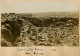
Locketts Fault in lava, 1900
1900
Image
uum_map
1453
Lone tree in Monument Valley.
1956
Image
uum_map
1454
Looking across Little Colorado, short distance from ????, Echo Cliffs in background
1926
Image
uum_map
1455
Looking across Navajo Canyon toward Navajo Mt. (Stephen Janus photo)
1910
Image
uum_map
1456
Looking across Navajo Canyon, Arizona, toward Navajo Mountain. La Plata strata (Stephen Janus photo, 1909)
1909
Image
uum_map
1457
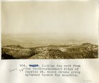
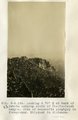
Looking due west from the southwesternmost ridge of Carrizo Mt. Shows Navaho group upturned toward the mountain.
1913
Image
uum_map
1458
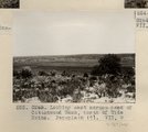
Looking east across head of Cottonwood Wash, north of Wide Ruins. Peneplain (?). VII, 9 (Photo G265)
1911
Image
uum_map
1459
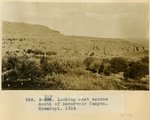
Looking east across mouth of Reservoir Canyon, Moenkopi, 1914
1914
Image
uum_map
1460
Looking N 15° W at base of highest point 6+ mi. east of Mexican Water. Navaho sandstone below, folded; Zuni sandstone above
1913
Image
uum_map
1461
Looking N 45° W at West side of Tees-Nos-Pos canyon at point where various branches unite. Navaho (Wingate) at base, overlain by Zuni, with monzonite above. Beds dip 15° N 50° E.
1913
Image
uum_map
1462
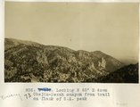
Looking N 65 degrees E down Chejin-Dezah canyon from trail on flank of S.E. peak
1913
Image
uum_map
1463
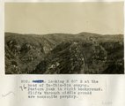
Looking N 80° E at the head of To-Chin-Sin canyon. Pastora Peak in right background. Cliffs through middle ground are monzonite porphyry.
1913
Image
uum_map
1464
Looking N 80° W at dike in canyon south of Chejin-Dezah Canyon
1913
Image
uum_map
1465
Looking N 85° E at Volcanic Neck 8± mi. north of Red Rock Store
1913
Image
uum_map
1466
Looking S 30° W at north side of Tse-logan Canyon. Wingate member of the Navajo sandstone, conformably overlying Chinlee shales. Dip 15 degrees W
1913
Image
uum_map
1467
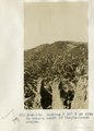
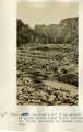
Looking S 60° W up canyon at point where lower trail enters it. Shows terraces in stream bottom.
1913
Image
uum_map
1468
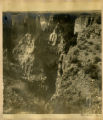
Looking S 65° W up Tees-Nos-Pos Canyon, 1/4 mi.± above waterfall, showing control of joints.
1913
Image
uum_map
1469
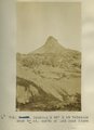
Looking S 75° E at back of Dakota outcrop south of Chejin-Dezah canyon. Dike of monzonite porphyry in foreground. Shiprock in distance.
1913
Image
uum_map
1470
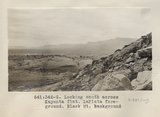
Looking south across Kayenta flat. LaPlata foreground. Black Mt. background (Photo G342)
1913
Image
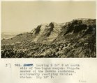
uum_map
1471
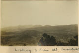
Looking South from Mt Trumbull
1900
Image
uum_map
1472
Looking up Bright Angel Creek from south bank, Colorado... N.P. Service photo, 1928?
1928
Image
uum_map
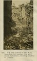
1473
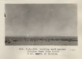
Looking up canyon of lower Kanab Creek from a point 3 miles below the mouth of Snake Gulch. AZ. 1922
1922
Image
uum_map
1474
Looking up Phantom Canyon from bed of Bright Angel Creek, 1928?
1928
Image
uum_map
1475
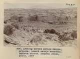
Looking west across Chinlee Wash from Point 5 mi. north of Chinlee (Photo N-M153)
1913
Image
uum_map
1451
-
1475
of
2,504
<
54
55
56
57
58
59
60
61
62
63
>