Home
Browse
Ask Us
Chat
Harmful Language Statement
Log in
Advanced Search
Year
1864
1865
1866
1867
1868
1869
1870
1871
1872
1873
1874
1875
1876
1877
1878
1879
1880
1881
1882
1883
1884
1885
1886
1887
1888
1889
1890
1891
1892
1893
1894
1895
1896
1897
1898
1899
1900
1901
1902
1903
1904
1905
1906
1907
1908
1909
1910
1911
1912
1913
1914
1915
1916
1917
1918
1919
1920
1921
1922
1923
1924
1925
1926
1927
1928
1929
1930
1931
1932
1933
1934
1935
1936
1937
1938
1939
1940
1941
1942
1943
1944
1945
1946
1947
1948
1949
1950
1951
1952
1953
1954
1955
1956
1957
1958
1959
1960
1961
1962
1963
1964
1965
1966
1967
1968
1969
1970
1971
1972
1973
1974
1975
1976
1977
1978
1979
1980
1981
1982
1983
1984
1985
1986
1987
1988
1989
1990
1991
1992
1993
1994
1995
1996
1997
1998
1999
2000
2001
2002
2003
2004
2005
TO
1864
1865
1866
1867
1868
1869
1870
1871
1872
1873
1874
1875
1876
1877
1878
1879
1880
1881
1882
1883
1884
1885
1886
1887
1888
1889
1890
1891
1892
1893
1894
1895
1896
1897
1898
1899
1900
1901
1902
1903
1904
1905
1906
1907
1908
1909
1910
1911
1912
1913
1914
1915
1916
1917
1918
1919
1920
1921
1922
1923
1924
1925
1926
1927
1928
1929
1930
1931
1932
1933
1934
1935
1936
1937
1938
1939
1940
1941
1942
1943
1944
1945
1946
1947
1948
1949
1950
1951
1952
1953
1954
1955
1956
1957
1958
1959
1960
1961
1962
1963
1964
1965
1966
1967
1968
1969
1970
1971
1972
1973
1974
1975
1976
1977
1978
1979
1980
1981
1982
1983
1984
1985
1986
1987
1988
1989
1990
1991
1992
1993
1994
1995
1996
1997
1998
1999
2000
2001
2002
2003
2004
2005
Type
Image
2,504
Text
2
Format
image/jpeg
2,384
application/pdf
118
Collection
American Westward Migration
1
Beckwith Photograph Collection
6
Classified Photographs
285
Photo Archives
1,767
Shipler Commercial Photographers
2
Utah River Running Photo Archives
440
Vernal Express Photographs
1
Western Waters Electronic Resources
2
More
Filters:
Spatial Coverage:
"Arizona"
Type:
"Image"
1026
-
1050
of
2,504
<
37
38
39
40
41
42
43
44
45
46
>
Gallery view
Number of results to display per page
10
25
50
100
200
Sort by Relevance
Sort by Title A-Z
Sort by Title Z-A
Sort by Date Ascending
Sort by Date Descending
Sort by Last Modified Ascending
Sort by Last Modified Descending
Title
Date
Type
Setname
1026
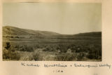
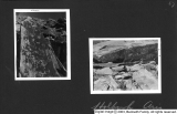
Kaibab Monocline & subsequent valley 1900
1900
Image
uum_map
1027
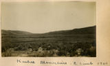
Kaibab Monocline, east limb 1900
1900
Image
uum_map
1028
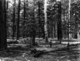
Kaibab National Forest P.1
Image
dha_cp
1029
Kaibab Plateau 1900
1900
Image
uum_map
1030
Kanab Canyon, 2 miles south, tributary Little Springs Canyon. Section includes Hermit Coconino, Kaibab, Coconino County, AZ. 1922
1922
Image
uum_map
1031
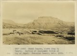
Kanab Canyon, above Jump Up Canyon. Surface of Esplanade formed at top of Supai. Coconino County, AZ. 1922
1922
Image
uum_map
1032
Kanab Canyon, above mouth of Jump Up Canyon. Surface and water pocket of 'Esplanade' developed at top of Supai. Coconino County, AZ. 1922
1922
Image
uum_map
1033
Kanab Canyon. View near mouth of tributary Little Springs Canyon. Coconino County, AZ. 1922
1922
Image
uum_map
1034
Kanab Creek, view looking toward mouth of Hack's Canyon. Stream intrenched in Supai, the top of which forms Esplanade. Strata are Supai, Hermit Coconino (forming slope), Kaibab sandstone and limestone, Kaibab cherty limestone. Coconino County, AZ. 1922
1922
Image
uum_map
1035
Kanab Valley, above the mouth of Jump Up Canyon. Section is Supai, erosional unconformity, Hermit Coconino, Kaibab sandstone, Kaibab limestone. Coconino County, AZ. 1922
1922
Image
uum_map
1036
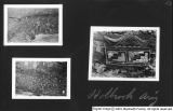
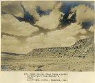
Kanosh, Black Rock, Pumice and Connor Spring scrapbook [34]
Image
dc_bpc
1037
Kanosh, Black Rock, Pumice and Connor Spring scrapbook [44]
Image
dc_bpc
1038
Kanosh, Black Rock, Pumice and Connor Spring scrapbook [45]
Image
dc_bpc
1039
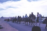
Kayenta parade celebrating completion of Route 1
1962-05-26
Image
uum_map
1040
Kayenta, Indigenous wagons
1962-05-26
Image
uum_map
1041
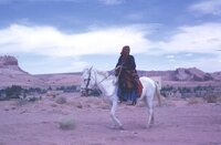
Kayenta, Indigenous woman on horse
1962-05-26
Image
uum_map
1042
Keams Canyon (Mesa Verde strata) looking west from Hubbell's store (A. C. Vroman photo, Pasadena, Cal.)
1909
Image
uum_map
1043
Keet Seel, cliff ruins east middle branch of Sagy (Towanaoche) canyon, Ariz., 1910 (Photo G165)
1910
Image
uum_map
1044
Keet Seel, Segi Canyon, Navajo Reservation (J.D.L. VerPlank photo)
1910
Image
uum_map
1045
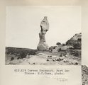
Kit Carson Monument. Fort Defiance. E.C.Case, photo
1913
Image
uum_map
1046
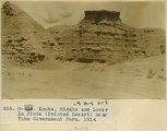
Knobs, Middle and Lower La Plata (Painted Desert) near Tuba Government Farm, 1914
1914
Image
uum_map
1047
Kolb Survey, 1921 P.9
1951
Image
dha_cp
1048
La Plata in Marsh Pass
1913
Image
uum_map
1049
La Plata sandstone 2± mi. east of Black Rock (Photo N-M139)
1913
Image
uum_map
1050
La Plata west side of Chinlee Wash, below Chinlee (Photo G327)
1913
Image
uum_map
1026
-
1050
of
2,504
<
37
38
39
40
41
42
43
44
45
46
>