Home
Browse
Ask Us
Chat
Harmful Language Statement
Log in
Advanced Search
Year
1864
1865
1866
1867
1868
1869
1870
1871
1872
1873
1874
1875
1876
1877
1878
1879
1880
1881
1882
1883
1884
1885
1886
1887
1888
1889
1890
1891
1892
1893
1894
1895
1896
1897
1898
1899
1900
1901
1902
1903
1904
1905
1906
1907
1908
1909
1910
1911
1912
1913
1914
1915
1916
1917
1918
1919
1920
1921
1922
1923
1924
1925
1926
1927
1928
1929
1930
1931
1932
1933
1934
1935
1936
1937
1938
1939
1940
1941
1942
1943
1944
1945
1946
1947
1948
1949
1950
1951
1952
1953
1954
1955
1956
1957
1958
1959
1960
1961
1962
1963
1964
1965
1966
1967
1968
1969
1970
1971
1972
1973
1974
1975
1976
1977
1978
1979
1980
1981
1982
1983
1984
1985
1986
1987
1988
1989
1990
1991
1992
1993
1994
1995
1996
1997
1998
1999
2000
2001
2002
2003
2004
2005
TO
1864
1865
1866
1867
1868
1869
1870
1871
1872
1873
1874
1875
1876
1877
1878
1879
1880
1881
1882
1883
1884
1885
1886
1887
1888
1889
1890
1891
1892
1893
1894
1895
1896
1897
1898
1899
1900
1901
1902
1903
1904
1905
1906
1907
1908
1909
1910
1911
1912
1913
1914
1915
1916
1917
1918
1919
1920
1921
1922
1923
1924
1925
1926
1927
1928
1929
1930
1931
1932
1933
1934
1935
1936
1937
1938
1939
1940
1941
1942
1943
1944
1945
1946
1947
1948
1949
1950
1951
1952
1953
1954
1955
1956
1957
1958
1959
1960
1961
1962
1963
1964
1965
1966
1967
1968
1969
1970
1971
1972
1973
1974
1975
1976
1977
1978
1979
1980
1981
1982
1983
1984
1985
1986
1987
1988
1989
1990
1991
1992
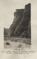
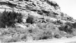
1993
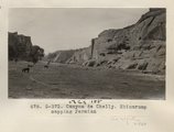
1994
1995
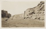
1996
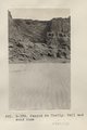
1997
1998
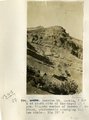
1999
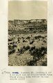
2000
2001
2002
2003
2004
2005
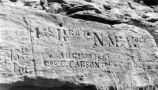
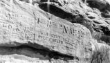
Type
Image
2,504
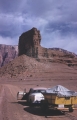
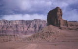
Text
2
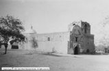
Format
image/jpeg
2,384
application/pdf
118
Collection
American Westward Migration
1
Beckwith Photograph Collection
6
Classified Photographs
285
Photo Archives
1,767
Shipler Commercial Photographers
2
Utah River Running Photo Archives
440
Vernal Express Photographs
1
Western Waters Electronic Resources
2
More
Filters:
Spatial Coverage:
"Arizona"
Type:
"Image"
276
-
300
of
2,504
<
7
8
9
10
11
12
13
14
15
16
>
Gallery view
Number of results to display per page
10
25
50
100
200
Sort by Relevance
Sort by Title A-Z
Sort by Title Z-A
Sort by Date Ascending
Sort by Date Descending
Sort by Last Modified Ascending
Sort by Last Modified Descending
Title
Date
Type
Setname
276
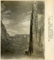
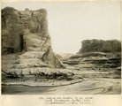
Canyon de Chelly, view down stream at "The Captains" (Moencopie strata), 1909 (W. C. Mendenhall, photo, U.S.G.S.)
1909
Image
uum_map
277
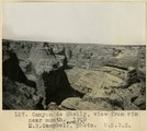
Canyon de Chelly, view from rim near mouth, 1909 (M. R. Campbell, photo, U.S.G.S.)
1909
Image
uum_map
278
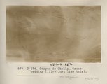
Canyon de Chelly. Cross-bedding (III-9 just like this) (Photo G374)
1913
Image
uum_map
279
Canyon de Chelly. Cross-bedding (III-9 just like this) (Photo G374)
1913
Image
uum_map
280
Canyon de Chelly. Portion of wall, Shinarump on top (Photo G375)
1913
Image
uum_map
281
Canyon de Chelly. Shinarump capping Permian (Photo G373)
1913
Image
uum_map
282
Canyon de Chelly. Shinarump capping Permian (Photo G373)
1913
Image
uum_map
283
Canyon de Chelly. VII, 26 (Photo N-M131)
1911
Image
uum_map
284
Canyon de Chelly. Wall and sand dune (Photo G376)
1913
Image
uum_map
285
Canyon del Muerto, 2± mi. above mouth (Moencopie strata), 1909 (W. C. Mendenhall, photo, U.S.G.S.)
1909
Image
uum_map
286
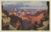
Canyon from Grand View, Grand Canyon National Park, Arizona
1930; 1931; 1932; 1933; 1934; 1935; 1936; 1937; 1938; 1939; 1940; 1941; 1942; 1943; 1944; 1945
Image
uum_map
287
Canyon of the Little Colorado below Cameron.
1941
Image
uum_map
288
Carriso Mt., Ariz., W. B. Emory photo, 1909
1909
Image
uum_map
289
Carrizo Mt. Chinlee-Navaho (Wingate) contact in Cottonwood Dome. Chinee below hammer, Wingate above. Beds dip 11 °, N 15° E
1913
Image
uum_map
290
Carrizo Mt. looking 50° W at south side of Tse-lagai canyon. Wingate member of Navaho sandstone, conformably overlying Chinlee shale. Dip 15 degrees W
1913
Image
uum_map
291
Carrizo Mt. looking due west at amphitheater-like gulch on east side of Carrizo Mt. and south of Chejin-Dezah Canyon
1913
Image
uum_map
292
Carrizo Mt. looking S 30° E at west end of Chejin-Dezah Mesa. Shows cirque-like basins in monsonite cliff
1913
Image
uum_map
293
Carson, Christopher--Inscription P.1
Image
dha_cp
294
Carson, Christopher--Inscription P.2
Image
dha_cp
295
Carson, Christopher--Inscription P.3
Image
dha_cp
296
Cathedral Rock on the road to Lees Ferry, Arizona, 1960
1960
Image
uum_map
297
Cathedral Rock on the road to Lees Ferry, Arizona, before Grand Canyon boating trip
1960
Image
uum_map
298
Catholic Churches p.4
1930; 1931; 1932; 1933; 1934; 1935; 1936; 1937; 1938; 1939
Image
dha_cp
299
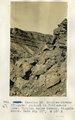
Cedar Ridge. Cap of Shinarump conglomerate and upper Moenkopi extending south from Vermillion Cliffs onto Uinkaret Plateau west of Pipe Wash, Mohave County, AZ. 1939
1939
Image
uum_map
300
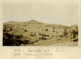
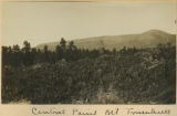
Central point, Mt. Trumbull
1900
Image
uum_map
276
-
300
of
2,504
<
7
8
9
10
11
12
13
14
15
16
>